
Catastrophic Plate Tectonics: A Global Flood Model of Earth History
by
Dr. Steve Austin, Dr. John Baumgardner, Dr. Russell Humphreys, Dr. Andrew A. Snelling, Dr. Larry Vardiman,
and
Kurt P. Wise
on
October 27, 2010
Featured in
Answers in Depth
Abstract
In 1859 Antonio Snider proposed that rapid, horizontal divergence of crustal plates occurred during Noah’s Flood. Modern plate tectonics theory is now conflated with assumptions of uniformity of rate and ideas of continental “drift.” Catastrophic plate tectonics theories, such as Snider proposed more than a century ago, appear capable of explaining a wide variety of data—including biblical and geologic data which the slow tectonics theories are incapable of explaining. We would like to propose a catastrophic plate tectonics theory as a framework for Earth history. Geophysically, we begin with a pre-Flood earth differentiated into core, mantle, and crust, with the crust horizontally differentiated into sialic craton and mafic ocean floor. The Flood was initiated as slabs of oceanic floor broke loose and subducted along thousands of kilometers of pre-Flood continental margins. Deformation of the mantle by these slabs raised the temperature and lowered the viscosity of the mantle in the vicinity of the slabs. A resulting thermal runaway of the slabs through the mantle led to meters-per-second mantle convection. Cool oceanic crust which descended to the core/mantle boundary induced rapid reversals of the earth’s magnetic field. Large plumes originating near the core/mantle boundary expressed themselves at the surface as fissure eruptions and flood basalts. Flow induced in the mantle also produced rapid extension along linear belts throughout the sea floor and rapid horizontal displacement of continents. Upwelling magma jettisoned steam into the atmosphere causing intense global rain. Rapid emplacement of isostatically lighter mantle material raised the level of the ocean floor, displacing ocean water onto the continents. When virtually all the pre-Flood oceanic floor had been replaced with new, less-dense, less-subductable, oceanic crust, catastrophic plate motion stopped. Subsequent cooling increased the density of the new ocean floor, producing deeper ocean basins and a reservoir for post-Flood oceans. Sedimentologically, we begin with a substantial reservoir of carbonate and clastic sediment in the pre-Flood ocean. During the Flood hot brines associated with new ocean floor added precipitites to that sediment reservoir, and warming ocean waters and degassing magmas added carbonates—especially high magnesium carbonates. Also during the Flood, rapid plate tectonics moved pre-Flood sediments toward the continents. As ocean plates subducted near a continental margin, its bending caused upwarping of sea floor, and its drag caused downwarping of continental crust, facilitating the placement of sediment onto the continental margin. Once there, earthquake-induced sea waves with ocean-to-land movement redistributed sediment toward continental interiors. Resulting sedimentary units tend to be thick, uniform, of unknown provenance, and extend over regional, inter-regional, and even continental areas.
This paper was originally published in the Proceedings of the Third International Conference on Creationism, pp. 609–612 (1994) and is reproduced here with the permission of the Creation Science Fellowship of Pittsburgh (www.csfpittsburgh.org).
Keywords: catastrophe, Flood model, plate tectonics, subduction, thermal runaway, convection, spreading, fountains of the great deep, windows of heaven, volcanoes, earthquakes, sediments, precipitites, magnetic reversals, isostasy, climate, Ice Age
Introduction
Early in the history of geology, it was common to appeal to the Flood described in Scripture to explain the origin of most or all rocks and fossils (for example, Burnet,1 Steno,2 Whiston,3 Woodward4). In such theories Noah’s Flood was typically recognized as a catastrophic event of global proportions. The earth’s crust was typically pictured as dynamic and capable of rapid vertical and horizontal motions on local, regional, and global scales. However, especially with the influential works of Hutton5,6 and then Lyell,7 Noah’s Flood began to play an increasingly less important role in historical geology during the nineteenth century. Theories of gradualism increased in popularity as theories of catastrophism waned. Ideas of past catastrophic geology were replaced with ideas of constancy of present gradual physical processes. Ideas of global-scale dynamics were replaced with ideas of local erosion, deposition, extrusion, and intrusion. Ideas of rapid crustal dynamics were replaced by ideas of crustal fixity—with only imperceptibly slow vertical subsidence and uplift being possible. So complete was the success of gradualism in geology that ideas of flood geology were nowhere to be found among the English-speaking scientists of the world by 1859,8 or rarely found at best.9
One of the last holdouts for flood geology was a little-known work published by Antonio Snider-Pellegrini10—ironically enough the same year Darwin published the Origin of Species. Intrigued by the reasonably good fit between land masses on either side of the Atlantic ocean, Snider proposed that the earth’s crust was composed of rigid plates which had moved horizontally with respect to one another. Snider may have been the first to propose some of the main elements of modern plate tectonics theory. Snider also proposed that the horizontal divergence had been rapid and had occurred during Noah’s Flood. It appears, then, that the first elaboration of plate tectonics theory was presented in the context of catastrophic flood geology. It also seems that a substantial amount of the twentieth century opposition to plate tectonics was due to the fact that geologists were, by then, firmly predisposed to believe that the earth’s crust was horizontally fixed. The catastrophism school of geology was the first to propose plate tectonics; the gradualist school was the first major opponent to plate tectonics. However, by the time plate tectonics was finally accepted in the United States in the late 1960s, gradualism had become a part of plate tectonics theory as well. Rather than Snider’s rapid horizontal motion on the scale of weeks or months, modern geology accepted a plate tectonics theory with horizontal motion on the scale of tens to hundreds of millions of years.
Because of the enormous explanatory and predictive success of the plate tectonics model (reviewed in Wise11,12), we feel that at least some portion of plate tectonics theory should be incorporated into the creation model. It appears that taking the conventional plate tectonics model and increasing the rate of plate motion neither deprives plate tectonics theory of its explanatory and predictive success, nor does it seem to contradict any passages of Scripture. Therefore, following the example of Antonio Snider we would like to propose a model of geology which is centered about the idea of rapid, horizontal divergence of rigid crustal plates (that is, rapid plate tectonics) during Noah’s Flood. We feel that this model is not only capable of the explanatory and predictive success of conventional plate tectonics, but is also capable of clarifying a number of scriptural claims and explaining some physical data unexplained by conventional plate tectonics theory.
It is important to note, however, that our model is still in its formative stages, and is thus incomplete. What is presented here is a basic framework upon which more theory can be built. We anticipate that a substantial amount of work is still needed to explain all the salient features of this planet’s rocks and fossils. Additionally, although the authors of this paper have all had some association with the Institute for Creation Research (ICR), the model presented in this paper is a composite perspective of the authors and not necessarily that of the ICR.
Pre-Flood Geology
Any flood model must begin by speculating on the nature of the pre-Flood world. Virtually every flood event and product is in some way or another affected by characteristics of the pre-Flood world. A partial list of flood events determined at least in part by pre-Flood conditions would include: global dynamics of the crust (by the pre-Flood structure and nature of the earth’s interior); magnetic field dynamics (by the pre-Flood nature of the magnetic field); tectonic activity and associated earthquakes (by the pre-Flood structure and dynamics of the crust); volcanic activity and emplaced igneous rocks (by the pre-Flood nature of the earth’s interior); formation of clastic sediments (by the pre-Flood sediments available for redeposition and rocks available for erosion); formation of chemical sediments (by the pre-Flood ocean chemistry); formation of fossils (by the nature of the pre-Flood biota); distribution of sediments and fossils (by the pre-Flood climate and biogeography); and the dynamics of the inundation itself (by pre-Flood topography). The more that is determined about the nature of the pre-Flood world, the more accurate and specific our flood models can be. Our initial inferences about the pre-Flood world include the following.
Pre-Flood/Flood boundary
We agree with many previous theorists in flood geology that the pre-Flood/Flood boundary should stratigraphically lie at least as low as the Precambrian/Cambrian boundary (for example, Steno13, Whitcomb and Morris14). Currently there is discussion about how close (Austin and Wise15, Wise16) or far (Snelling17) below the Cambrian rocks this boundary should be located. For our purposes here, it is provisionally claimed that at least many of the Archean sediments are pre-Flood in age.
Pre-Flood earth structure
We believe that the pre-Flood earth was differentiated into a core, mantle, and crust, very much as it is today. We conclude this for two major reasons. The first is that under any known natural conditions, core/mantle differentiation would destroy all evidence of life on earth completely. The current earth has a core/mantle/crust division according to the successively lower density of its components. If this differentiation had occurred by any natural means, the gravitational potential energy released by the heavier elements relocating to the earth’s interior would produce enough heat to melt the earth’s crust and vaporize the earth’s oceans. If differentiation of the earth’s elements did occur with its associated natural release of energy, it is reasoned that it most certainly occurred before the creation of organisms (at the latest Day 3 of the Creation week). Secondly, even though such a differentiation could have been performed by God without the “natural” release of gravitational potential energy, the already-differentiated earth’s interior also provides a natural driving mechanism for the rapid tectonics model here described.
The earth’s mantle appears to have been less viscous than it seems to be at present (Baumgardner18,19,20). This is to allow for the thermal runaway instability which we believe produced the rapid plate tectonic motion we are proposing.21
With regard to the earth’s crust, we believe that there was a distinct horizontal differentiation between oceanic and continental crust, very much as there is today. First, we believe that before the Flood began, there was stable, sialic, cratonic crust. We have three major reasons for this conclusion:
- much Archean sialic material exists which probably is below the pre-Flood/Flood boundary. This would indicate that sialic material was available in pre-Flood times;
- the existence of low-density, low temperature “keels” beneath existing cratons22 implies that the cratons have persisted more or less in their present form since their differentiation. It also argues that little or no mantle convection has disturbed the upper mantle beneath the cratons; and
- if the pre-Flood cratons were sialic and the pre-Flood ocean crust was mafic, then buoyancy forces would provide a natural means of supporting craton material above sea level—thus producing dry land on the continents.
Second, we believe that the pre-Flood ocean crust was mafic—most probably basaltic. Once again three reasons exist for this inference:
- pre-Flood basaltic ocean crust is suggested by ophiolites (containing pillow basalts and presumed ocean sediments) which are thought to represent pieces of ocean floor and obducted onto the continents early in the Flood;
- if, as claimed above, the pre-Flood craton was sialic, then buoyancy forces would make a mafic pre-Flood ocean crust into a natural basin for ocean water. This would prevent ocean water from overrunning the continents; and
- if, as claimed above, the continents were sialic, mafic material would be necessary to drive the subduction required in our Flood model.
Pre-Flood sediments
We believe that there was a significant thickness of all types of sediments already available on the earth by the time of the Flood. We have three reasons for this position:
- biologically optimum terrestrial and marine environments would require that at least a small amount of sediment of each type had been created in the Creation week;
- Archean (probable pre-Flood) and Proterozoic sediments contain substantial quantities of all types of sediments; and
- it may not be possible to derive all the Flood sediments from igneous and/or metamorphic precursors by physical and chemical processes in the course of a single, year-long Flood.
We believe that substantial quantities of very fine detrital carbonate sediment existed in the pre-Flood oceans. This is deduced primarily from the fact that not enough bicarbonate can have been dissolved in the pre-Flood ocean (and/or provided by outgassing during the Flood—see below) to have produced the Flood carbonates.
Such quantities of carbonate as we believe to have existed in the pre-Flood ocean would mean that there was a substantial buffer in the pre-Flood ocean—perhaps contributing to a very stable pre-Flood ocean chemistry. The existence of large quantities of mature or nearly mature pre-Flood quartz sands might explain the otherwise somewhat mysterious clean, mature nature of early Paleozoic sands.
Flood Dynamics
Initiation
There has been considerable discussion—both reasonable and fanciful—about what event might have initiated the Flood. Considerations range from
- the direct hand of God (Baumgardner23,24, Morton25,26,27,28,29,30,31);
- the impact or near-miss of an astronomical object or objects such as asteroids,32 meteorites,33 a comet,34,35 a comet or Venus,36 Venus and Mars,37 Mars,38 Mars, Ceres, and Jupiter,39 another moon of earth,40 and a star;41
- some purely terrestrial event or events, such as fracturing of the earth’s crust due to drying42 or radioactive heat buildup,43 rapid tilting of the earth due to gyro turbulence44 or ice sheet buildup,45 and natural collapse of rings of ice;46,47 or
- various combinations of these ideas.
We feel that the Flood was initiated as slabs of oceanic crust broke loose and subducted along thousands of kilometers of pre-Flood continental margins. We are, however, not ready at this time to speculate on what event or events might have initiated that subduction. We feel that considerable research is still needed to evaluate potential mechanisms in the light of how well they can produce global subduction.
Subduction
At the very beginning of plate motion, subducting slabs locally heated the mantle by deformation, lowering the viscosity of the mantle in the vicinity of the slabs. The lowered viscosity then allowed an increase in subduction rate, which in turn heated up the surrounding mantle even more. We believe that this led to a thermal runaway instability which allowed for meters-per-second subduction, as postulated and modeled by Baumgardner.48,49 It is probable that this subduction occurred along thousands of kilometers of continental margin. The bending of the ocean plate beneath the continent would have produced an abrupt topographic low paralleling the continental margin, similar to the ocean trenches at the eastern, northern, and western margins of the Pacific Ocean.
Because all current ocean lithosphere seems to date from Flood or post-Flood times,50 we feel that essentially all pre-Flood ocean lithosphere was subducted in the course of the Flood. Gravitational potential energy released by the subduction of this lithosphere is on the order of 1028 J.51 This alone probably provided the energy necessary to drive Flood dynamics.
The continents attached to ocean slabs would have been pulled toward subduction zones. This would produce rapid horizontal displacement of continents—in many cases relative motion of meters per second. Collisions of continents at subduction zones are the likely mechanism for the creation of mountain fold-and-thrust-belts, such as the Appalachians, Himalayas, Caspians, and Alps. Rapid deformation, burial, and subsequent erosion of mountains possible in the Flood model might provide the only adequate explanation for the existence of high-pressure, low-temperature minerals such as coesite (for example, Chopin,52 Hsu,53 Shutong, Okay, Shouyuan, and Sengor,54 Smith,55 Wang, Liou, and Mao56) in mountain cores.
Mantle-Wide flow
As Baumgardner57,58 assumed in order to facilitate his modeling, rapid subduction is likely to have initiated large-scale flow throughout the entire mantle of the earth. Seismic tomography studies (for example, Dziewonski,59 and as reviewed by Engebretson, Kelley, Cushman, and Reynolds60) seem to confirm that this in fact did occur in the history of the earth. In such studies velocity anomalies (interpreted as cooler temperature zones) lie along theorized paths of past subduction. These anomalies are found deep within the earth’s mantle—well below the phase transition zones thought by some to be barriers to mantle-wide subduction. In fact, the velocity anomalies seem to imply that not only did flow involve the entire depth of the mantle, but that ocean lithosphere may have dropped all the way to the core/mantle boundary.
One important consequence of mantle-wide flow would have been the transportation of cooler mantle material to the core/mantle boundary. This would have had the effect of cooling the outer core, which in turn led to strong core convection. This convection provided the conditions necessary for Humphreys’ model of rapid geomagnetic reversals in the core.61,62 As the low electrical conductivity oceanic plates subducted, they would be expected to have split up the lower mantle’s high conductivity. This in turn would have lessened the mantle’s attenuation of core reversals and allowed the rapid magnetic field reversals to have been expressed on the surface. Humphreys’63,64 model not only explains magnetic reversal evidence (as reviewed in Humphreys65) in a young-age Creation timescale, but uniquely explains the low intensity of paleomagnetic and archeomagnetic data, the erratic frequency of paleomagnetic reversals through the Phanerozoic, and, most impressively, the locally patchy distribution of sea-floor paleomagnetic anomalies.66 It also predicted and uniquely explains the rapid reversals found imprinted in lava flows of the Northwest.67,68,69,70
Spreading
As ocean lithosphere subducted, it would have produced rapid extension along linear belts on the ocean floor tens of thousands of kilometers long. At these spreading centers upwelling mantle material would have been allowed to rise to the surface. The new, molten mantle material would have degassed its volatiles71 and vaporized ocean water72,73 to produce a linear geyser of superheated gases along the whole length of spreading centers. This geyser activity, which would have jettisoned gases well into the atmosphere, is, we believe, what Scripture refers to as the “fountains of the great deep” (Genesis 7:11; 8:2). As evidenced by volatiles emitted by Mount Kilauea in Hawaii,74 the gases released would be (in order of abundance) water, carbon dioxide, sulfur dioxide, hydrogen sulfide, hydrogen fluoride, hydrogen, carbon monoxide, nitrogen, argon, and oxygen. As the gases in the upper atmosphere drifted away from the spreading centers they would have had the opportunity to cool by radiation into space. As it cooled, the water—both that vaporized from ocean water and that released from magma—would have condensed and fallen as an intense global rain. It is this geyser-produced rain which we believe is primarily responsible for the rain from the “windows of heaven” (Genesis 7:11; 8:2) which remained a source of water for up to 150 days of the Flood (Genesis 7:24–8:2).
The rapid emplacement of isostatically lighter mantle material raised the level of the ocean floor along the spreading centers. This produced a linear chain of mountains called the mid-ocean ridge (MOR) system. The now warmer and more buoyant ocean floor displaced ocean water onto the continents to produce the inundation itself.
Continental modification
The events of the Flood would have made substantial modifications to the thickness of the pre-Flood continental crust. This would have been effected through the redistribution of sediments, the moving of ductile lower continental crust by subducting lithosphere, addition of molten material to the underside of the continental lithosphere (underplating), stretching (for example, due to spreading), and compression (for example, due to continental collision). These rapid changes in crustal thickness would produce isostatic disequilibrium. This would subsequently lead to large-scale isostatic adjustments with their associated earthquakes, frictional heating, and deformation. Since many of those tectonic events would have involved vertical rock motions, Tyler’s75 tectonically-controlled rock cycle might prove to be a useful tool in understanding late Flood and post-Flood tectonics.
Atmosphere
The magma at spreading centers degassed, among other things, substantial quantities of argon and helium into the earth’s atmosphere. Both of these elements are produced and accumulated due to radioactive decay. However, the current quantity of helium in the atmosphere is less than that which would be expected by current rates of radioactive decay production over a four to five billion years of earth history,76,77,78,79,80,81 so perhaps what is currently found in the atmosphere is due to degassing of mantle material during the Flood. The same may also be found to be true about argon.82
Flood waters
Several sources have been suggested for the water of the Flood. Some creationists83,84 have proposed that the “waters above the firmament” in the form of an upper atmosphere water canopy provided much of the rain of the Flood. However, Rush and Vardiman85,86 and Walters87 argue that if the water was held in place by forces and laws of physics with which we are currently familiar, 40 feet of water is not possible in the canopy. Perhaps, they argue, the canopy could have held a maximum of only a few feet of water. This is insufficient water to contribute significantly to even 40 days of rain, let alone a mountain-covering global flood. A second source suggested by Whitelaw88 and Baumgardner89,90 is condensing water from spreading center geysers. This should provide adequate water to explain up to 150 days of open “windows of heaven.” Another substantial source of water suggested by this model is displaced ocean water.91,92 Rapid emplacement of isostatically lighter mantle material at the spreading centers would raise the ocean bottom, displacing ocean water onto the continents. Baumgardner93 estimates a rise of sea level of more than one kilometer from this mechanism alone.
Cooling of new ocean lithosphere at the spreading centers would be expected to heat the ocean waters throughout the Flood. This heating seems to be confirmed by a gradual increase in 18O/16O ratios from the pre-Flood/Flood boundary through the Cretaceous (for example, Vardiman94).
Sedimentary production
Precipitites—sediments precipitated directly from supersaturated brines—would have been produced in association with horizontal divergence of ocean floor rocks. Rode95 and Sozansky96 have noted rock salt and anhydrite deposits in association with active sea-floor tectonics and volcanism and have proposed catastrophist models for their formation. Besides rock salt and anhydrite, hot-rock/ocean-water interactions could also explain many bedded chert deposits and fine-grained limestones.
Contributions to Flood carbonates probably came from at least four sources:
- carbon dioxide produced by degassing spreading center magmas;
- dissolved pre-Flood bicarbonate precipitated as ocean temperatures rose during the Flood (given that carbonate dissolution rates are inversely related to temperature);
- eroded and redeposited pre-Flood carbonates (a dominant pre-Flood sediment); and
- pulverized and redeposited pre-Flood shell debris. Precipitation of carbonate may explain the origin of micrite,97 so ubiquitous in Flood sediments, but of an otherwise unknown origin.98 Until pre-Flood ocean magnesium was depleted by carbonate precipitation, high-magnesium carbonates would be expected to be frequent products of early Flood activity (see Chillinger99 for interesting data on this subject).
Sedimentary transport
As Morton100 points out, most Flood sediments are found on the continents and continental margins and not on the ocean floor where one might expect sediments to have ended up. Our model provides a number of mechanisms for the transportation of ocean sediments onto the continents where they are primarily found today. First, subducting plates would transport sediments toward the subduction zones and thus mostly towards the continents in a conveyor-belt fashion. Second, as the ocean plates were forced to quickly bend into the earth’s interior, they would warp upward outboard of the trench. This would raise the deep sea sediments above their typical depth, which in turn reduces the amount of work required to move sediments from the oceans onto the continents. Third, rapid plate subduction would warp the continental plate margin downward. This again would reduce the amount of energy needed to move sediments onto the continent from the ocean floor. Fourth, as more and more of the cold pre-Flood ocean lithosphere was replaced with hotter rock from below, the ocean bottom is gradually elevated. This again reduces the work required to move sediments from the oceans to the continents. Fifth, as ocean lithosphere is subducted, ocean sediments would be scraped off, allowing sediments to be accreted to and/or redeposited on the continent. Sixth, wave (for example, tsunami) refraction on the continental shelf would tend to transport sediments shoreward. Seventh, it is possible that some amount of tidal resonance may have been achieved.101,102,103 The resulting east-to-west-dominated currents would tend to transport sediments accumulated on eastern continental margins into the continental interiors. Resulting sedimentary units have abundant evidence of catastrophic deposition104, and tend to be thick, uniform, of unknown provenance, and extending over regional, inter-regional, and even continental areas.105
Volcanic activity
The volcanism associated with rapid tectonics would have been of unprecedented magnitude and worldwide extent, but concentrated in particular zones and sites. At spreading centers magma would rise to fill in between plates separating at meters per second, producing a violent volcanic source tens of thousands of kilometers in length.106 Based upon two-dimensional experimental simulation107,108 and three-dimensional numerical simulation, subduction-induced mantle flow would generate mantle plumes whose mushroom heads would rise to and erupt upon the earth’s surface. These plumes would be expected to produce extensive flood basalts through fissure eruptions, such as perhaps the plateau basalts of South Africa, the Deccan Traps of India, the Siberian flood basalts,109 and the Karmutsen Basalt of Alaska/Canada.110 Correlations between plume formation and flood basalts have already been claimed (for example, Weinstein111). At the same time, the heating and melting of subducted sediments should have produced explosive sialic volcanism continent-ward of the subduction zone (such as is seen in the Andes Mountains of South America, the Cascade Mountains of the United States, and the Aleutian, Japanese, Indonesian, and New Zealand Islands of the Pacific).
Earthquake activity
The rapid bending of elastic lithosphere and rapid interplate shear of plates at subduction zones as well as abrupt phase transitions as subducting plates are rapidly moved downward would be expected to produce frequent, high-intensity earthquakes at the subduction zones. There is also earthquake activity associated with explosive volcanism, isostatic adjustment, continental collision, etc. This earthquake activity would facilitate thrust- and detachment-faulting by providing
- energy to aid in breaking up initially coherent rock blocks;
- an acceleration to aid in the thrusting of rock blocks; and
- vibration which reduces the frictional force resisting the motion and thrusting of rock blocks.
Termination
When virtually all the pre-Flood oceanic floor had been replaced with new, less-dense, less-subductable rock, rapid plate motion ceased. The lack of new, hot, mantle material terminated spreading-center-associated geyser activity, so the global rain ceased. This is very possibly the 150-day point in the Genesis chronology when it appears that the “fountains of the great deep were stopped and the windows of the heaven were closed” (Genesis 8:2).
After the rapid horizontal motion stopped, cooling increased the density of the new ocean floor producing gradually deepening oceans112—eventually producing our current ocean basins. As the waters receded (the “Great Regression”) from off of the land the most superficial—and least lithified—continental deposits were eroded off the continents. This would leave an unconformity on the continent not reflected in ocean stratigraphy. The absence of these most superficial continental deposits may explain the absence of human as well as most mammal and angiosperm fossils in Flood sediments.113 Sheet erosion from receding Flood waters would be expected to have planed off a substantial percentage of the earth’s surface. Such planar erosion features as the Canadian shield and the Kaibab and Coconino plateaus might well be better explained by this than by any conventional erosional processes.
Post-Flood Dynamics
Flood/post-Flood boundary
The definition of the Flood/post-Flood boundary in the geologic column is a subject of considerable dispute among creationists. Estimates range from the Carboniferous114 to the Pleistocene.115,116 For our purposes here we would like to define the Flood/post-Flood boundary at the termination of global-scale erosion and sedimentation. Based upon a qualitative assessment of geologic maps worldwide, lithotypes change from worldwide or continental in character in the Mesozoic to local or regional in the Tertiary. Therefore, we tentatively place the Flood/post-Flood boundary at approximately the Cretaceous/Tertiary (K/T) boundary. We believe further studies in stratigraphy, paleontology, paleomagnetism, and geochemistry should allow for a more precise definition of this boundary.
Post-Flood geology
After the global effects of the Flood ended, the earth continued to experience several hundred years of residual catastrophism.117 A cooling lithosphere is likely to have produced a pattern of decreasing incidence118 and intensity of volcanism (such as appears to be evidenced in Cenozoic sialic volcanism in the Western United States.119 The large changes in crustal thicknesses produced during the Flood left the earth in isostatic disequilibrium. lsostatic readjustments with their associated intense mountain uplift, earthquake, and volcanic activity would have occurred for hundreds of years after the global affects of the Flood ended (for example, Rugg120). In fact, considering the current nature of the mantle, there has not been sufficient time since the end of the Flood for complete isostatic equilibrium to be attained. As a result, current geologic activity can be seen as continued isostatic readjustments to Flood events. Modern earthquake and volcanic activity is in some sense relict Flood dynamics.
Because of the frequency and intensity of residual catastrophism after the Flood, post-Flood sedimentary processes were predominantly rapid. The local nature of such catastrophism, on the other hand, restricted sedimentation to local areas, explaining the basinal nature of most Cenozoic sedimentation.
Post-Flood climate
By the time Flood waters had settled into the post-Flood basins, they had accumulated enough heat to leave the oceans as much as twenty or more degrees centigrade warmer than today’s oceans (fig. 1). These warmer oceans might be expected to produce a warmer climate on earth in the immediate post-Flood times than is experienced on earth now.121 More specifically, a rather uniform warm climate would be expected along continental margins,122,123,124 permitting wider latitudinal range for temperature-limited organisms125—for example, mammoths (for example, Schweger et al.126), frozen forests (for example, Felix127), and trees.128 This avenue in turn may have facilitated post-Flood dispersion of animals.129,130 Also expected along continental margins would be a rather high climatic gradient running from the ocean toward the continental interior.131,132 This might explain why some Cenozoic communities near the coasts include organisms from a wider range of climatic zones than we would expect to see today—for example, communities in the Pleistocene133,134 and the Gingko Petrified Forest in Oregon.135
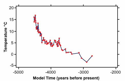
Fig. 1. Cooling of polar bottom water after the Flood (after Vardiman139). Data from Kennett et al.140 and Shackleton and Kennett.141
Oard136,137,138 suggested that within the first millennium following the Flood, the oceans (and earth) would have cooled as large amounts of water were evaporated off of the oceans and dropped over the cooler continental interiors. Although Oard’s model needs substantial modification (for example, to include all the Cenozoic), quantification, and testing, we feel that it is likely to prove to have considerable explanatory and predictive power. The predicted cooling142,143 seems to be confirmed by oxygen isotope ratios in Cenozoic foraminifera of polar bottom144,145,146 (fig. 1), polar surface, and tropical bottom waters, and may contribute to increased vertebrate body size (Cope’s Law147) throughout the Cenozoic. Oard148 suggests that the higher rates of precipitation may provide a unique explanation for a well-watered Sahara of the past,149,150,151 rapid erosion of caves, and the creation and/or maintenance of large interior continental lakes of the Cenozoic. Examples of the latter include Quaternary pluvial lakes,152,153 Lakes Hopi and Canyonlands, which may have catastrophically drained to produce Grand Canyon,154,155,156 and the extensive lake which produced the Eocene Green River deposits. We would expect floral and faunal communities to have tracked the cooling of the oceans and the corresponding cooling and drying of the continents. Such a tracking seems to explain the trend in Cenozoic plant communities to run from woodland to grassland and the corresponding trend in Cenozoic herbivores to change from browsers to grazers.
According to Oard’s157,158 model, by about five centuries after the Flood, the cooling oceans had led to the advance of continental glaciers and the formation of polar ice caps (see also Vardiman159). Oard160 suggests that rapid melting of the continental ice sheets (in less than a century) explains the underfitness of many modern rivers161 and contributed to the megafaunal extinctions of the Pleistocene.162,163,164 It may also have contributed to the production of otherwise enigmatic Pleistocene peneplains.
Conclusion
We believe that rapid tectonics provides a successful and innovative framework for young-age creation modeling of earth history. We feel that this model uniquely incorporates a wide variety of creationist and non-creationist thinking. It explains evidence from a wide spectrum of earth science fields—including evidence not heretofore well explained by any other earth history models.
Predictions
This model, like many Flood models, predicts the following:
- a consistent, worldwide, initiation event in the geologic column;
- most body fossils assigned to Flood deposits were deposited allochthonously (including coal, forests, and reefs);
- most ichnofossils assigned to Flood deposits are grazing, moving, or escape evidences, and not long-term living traces; and
- sediments assigned to the Flood were deposited subaqueously without long-term unconformities between them.
Since Flood models are usually tied to young-earth creationism, they also claim that it is possible on a short timescale to explain
- the cooling of plutons and ocean plate material;
- regional metamorphism (see, for example, Snelling165,166);
- canyon and cave erosion;
- sediment production and accumulation (including speleothems and precipitites);
- organismal accumulation and fossilization (including coal, fossil forests, and reefs);
- fine sedimentary lamination (including varves); and
- radiometric data.
This particular model also predicts
- a lower earth viscosity in pre-Flood times;
- degassing-associated subaqueous precipitate production during the Flood;
- (possibly) east-to-west dominated current deposition during the Flood;
- (possibly) degassing-produced atmosphere argon and helium levels;
- a decrease in magnitude and frequency of geologic activity after the Flood;
- flood basalts that correlate with mantle plume events;
- a sedimentary unconformity at the Flood/post-Flood boundary on the continents not reflected in ocean sediments;
- current geologic activity is the result of relict, isostatic dynamics, not primary earth dynamics; and
- a single ice age composed of a single ice advance.
Future research
The Flood model presented here suggests a substantial number of research projects for young-earth creationists. Besides the further elaboration and quantification of the model, the predictions listed above need to be examined. Most significantly, we still need to solve the heat problem167,168 and the radiometric dating problem.169 As creationists we could also use the services of a geochemist to develop a model for the origin of carbonates and precipitites during the Flood. It is also important that we re-evaluate the evidence for multiple ice ages (as begun by Hughes170 and Oard171) and multiple ice advances (as begun by Molén172 and Oard173,174).
In addition to testing claims of the model, there are a number of other studies which could help us expand and refine the model. Successful studies on the nature of the pre-Flood world, for example, are likely to aid us in placing better parameters on our model. Events and factors postulated in the initiation of the Flood also need to be re-examined to determine which are capable of explaining the available data and the beginning of plate subduction. It is also important that we evaluate the role of extraterrestrial bombardment in the history of the earth and Flood, since it was most certainly higher during and immediately after the Flood than it is now (Gibson175, Whitelaw176). The suggestion that the earth’s axial tilt has changed (for example, Noone,177 Overn,178 Setterfield179) needs to be examined to determine validity and/or impact on earth history. It is also important that we determine how many Wilson cycles are needed to explain the data of continental motion (Mann and Wise,180 Wise, Stambaugh, and Mann181), and thus whether more than one phase of runaway subduction is necessary. More than one cycle may be addressed by partial separation and closure during one rapid tectonics event, and/or renewed tectonic motion after cooling of ocean floor allowed for further rapid tectonics. Finally, it will also be important to determine more precisely the geologic position of the initiation and termination of the Flood around the world in order to identify the geologic data relevant to particular questions of interest.
References

Footnotes
- Burnet, T. 1684. The theory of the earth: Containing an account of the original of the earth and of all the changes which it hath already undergone, or is to undergo, until the consummation of all things. London (shorter version originally published in Latin, 1681).
- Steno, N. 1677. De solido intra solidum naturaliter contento dissertationis prodomus (Prodromus to a dissertation on a solid body naturally contained within a solid). Florence.
- Whiston, W. 1697. A new theory of the earth: From its origin, to the consummation of all things wherein the Creation of the world in six days, the universal deluge and general conflagration as laid down in the Holy Scriptures are shewn to be perfectly agreeable to reason and philosophy. London: B. Tooke.
- Woodward, J. 1695. An essay towards a natural history of the earth . . . with an account of the universal deluge and of the effects it had upon the earth. London: R. Wilkin.
- Hutton, J. 1788. Theory of the earth, with proofs and illustrations (2 volumes). Edinburgh: Cadell & Davies.
- Hutton, J. 1795. The theory of the earth. Edinburgh: William Creech.
- Lyell, C. 1830–1833. Principles of geology: being an attempt to explain the former changes of the earth’s surface by reference to causes now in operation (Vol. 1, 1830; Vol. 2, 1832; Vol. 3, 1833). London: John Murray.
- Numbers, R. L. 1992. The creationists: The evolution of scientific creationism. New York: Knopf.
- Nelson, B. C. 1931. The deluge story in stone: A history of the Flood theory in geology. Minneapolis, Minnesota: Bethany.
- Snider-Pellegrini, A. 1859 early release, 1858. La création et ses mystères dévoilés. Paris: A. Franck et E. Dentu.
- Wise, K. P. in prep. (a).Creationism and plate tectonics: A re-evaluation of the evidence.
- Wise, K. P. in prep. (b). Ecological zonation and the fossil record.
- Steno, Ref. 2.
- Whitcomb, J. C. Jr. and H. M. Morris. 1961. The Genesis Flood: The biblical record and its scientific implications. Philadelphia, Pennsylvania: Presbyterian and Reformed.
- Austin, S. A. and K. P. Wise. 1994. The pre-Flood/Flood boundary: as defined in Grand Canyon, Arizona, and East Mojave, California. In Walsh, R. E. (ed.), Proceedings of the third international conference on creationism, pp. 37–47. Pittsburgh, Pennsylvania: Creation Science Fellowship.
- Wise, K. P. 1992a. Some thoughts on the Precambrian fossil record. Creation Ex Nihilo Technical Journal 6 no. 1:67–71.
- Snelling, A. A. 1991. Creationist geology: Where do the ‘Precambrian’ strata fit? Creation Ex Nihilo Technical Journal 5 no. 2:154–175.
- Baumgardner, J. R. 1987. Numerical simulation of the large-scale tectonic changes accompanying the Flood. In Walsh, R. E., C. L. Brooks, and R. S. Crowell (eds.), Proceedings of the first international conference on creationism, 2:17–30. Pittsburgh, Pennsylvania: Creation Science Fellowship.
- Baumgardner, J. R. 1990a. 3-D finite element simulation of the global tectonic changes accompanying Noah’s Flood. In Walsh, R. E. and C. L. Brooks (eds.), Proceedings of the second international conference on creationism 2:35–45. Pittsburgh, Pennsylvania: Creation Science Fellowship.
- Baumgardner, J. R. 1990b. The imperative of non-stationary natural law in relation to Noah’s Flood. Creation Research Society Quarterly 27 no. 3:98–100.
- Baumgardner, Ref. 19.
- Jordon, T. H. 1978. Composition and development of the continental tectosphere. Nature 274:544–548.
- Baumgardner, Ref. 18.
- Baumgardner, Ref. 19.
- Morton, G. R. 1980. Prolegomena to the study of the sediments. Creation Research Society Quarterly 17:162–167.
- Morton, G. R. 1981. Creationism and continental drift. Creation Research Society Quarterly 18:42–45.
- Morton, G. R. 1982. Electrodynamics and the appearance of age. Creation Research Society Quarterly 18:227–232.
- Morton, G. R. 1983. The Flood and an expanding earth. Creation Research Society Quarterly 19:219–226.
- Morton, G. R. 1987a. Mountain synthesis on an expanding earth. Creation Research Society Quarterly 24:53–58.
- Morton, G. R. 1987b. The geology of the Flood. Dallas, Texas: DMD.
- Morton, G. R. 1990. Changing constants and the cosmos. Creation Research Society Quarterly 27:60–67.
- Unfred, D. W. 1984. Asteroidal impacts and the Flood-judgment. Creation Research Society Quarterly 21 no. 2:82–87.
- Parks, W. S. 1989. The role of meteorites in a creationist cosmology. Creation Research Society Quarterly 26:144–146.
- Patten, D. W. 1966. The Biblical Flood and the ice epoch: A study in scientific history. Seattle, Washington: Pacific Meridian.
- Whiston, Ref. 3.
- Berlitz, C. 1987. The lost ship of Noah: In search of the Ark at Ararat. New York: G. P. Putnam’s Sons.
- Velikovsky, I. 1955. Earth in upheaval. New York: Doubleday.
- Patten, D. W., R. R. Hatch, and L. C. Steinhauer. 1973. The Long Day of Joshua and six other catastrophes: A unified theory of catastrophism. Seattle, Washington: Pacific Meridian.
- Whitelaw, R. L. 1983. The fountains of the great deep and the windows of heaven: A look at the canopy theory, and of a better alternative. In Science at the crossroads: Observation or speculation?: Papers of the 1983 national creation conference, pp. 95–104. Minneapolis, Minnesota: Bible-Science Association.
- Bellamy, H. S. 1936. Moons, myths, and man. New York, New York: Harper.
- Benson, C. H. 1929. The earth—the theatre of the universe: and a scientific and scriptural study of the earth’s place and purpose in the divine program. Chicago, Illinois: Bible Institute Colportage Association.
- Burnet, Ref. 1.
- Henry, J. F. 1992. Space age astronomy confirms a recent and special Creation. In Proceedings of the 1992 twin-cities creation conference, pp. 88–90. St. Paul, Minnesota: Twin Cities Creation-Science Association.
- Overn, B. 1992. The tilt of the earth’s axis: Its orientation brings the new age; Its history reveals the Flood and explains the magnetic reversals. In Proceedings of the 1992 twin-cities creation conference, pp. 83–87. St. Paul, Minnesota: Twin Cities Creation-Science Association.
- McFarlane, P. ca 1850. Exposure of the principles of modern geology. Edinburgh: Thomas Grant.
- Vail, I. N. 1874. The waters above the firmament. Barnesville, Ohio.
- Webb, S. 1854. The Creation and the Deluge. According to a new theory: Confirming the Bible account removing most of the difficulties heretofore suggested by sceptical philosophers and indicating future cosmological changes down to the final consummation and end of the earth. Philadelphia, Pennsylvania.
- Baumgardner, Ref. 18.
- Baumgardner, Ref. 19.
- Sclater, J. G., C. Jaupart, and D. Galson. 1980. The heat flow through oceanic and continental crust and the heat loss of the earth. Reviews of Geophysics and Space Physics 18:269–311.
- Baumgardner, Ref. 18.
- Chopin, C. 1987. Very-high-pressure metamorphism in the western Alps: Implications for subduction of continental crust. In Oxburgh, E. R. (ed.). Tectonic settings of regional metamorphism: Proceedings of a royal society discussion meeting, pp. 183–197. London: Royal Society of London.
- Hsu, K. 1991. Exhumation of high-pressure metamorphic rocks. Geology 19:107–110.
- Shutong, X., A. I. Okay, J. Shouyuan, and A. M. C. Sengor, 1992. Diamond from the Dabie Shan metamorphic rocks and its implication for tectonic setting. Science 256:80–82.
- Smith, D. C. 1984. Coesite in clinopyroxene in the Caledonides and its implications for geodynamics. Nature 310:641–644.
- Wang, X., J. G. Liou, and H. K. Mao. 1989. Coesite-bearing eclogite from the Dabie Mountains, central China. Geology 17:1085–1088.
- Baumgardner, Ref. 18.
- Baumgardner, Ref. 19.
- Dziewonski, A. M. 1984. Mapping the lower mantle: Determination of lateral heterogeneity in P velocity up to degree and order 6. Journal of Geophysical Research 89:5929–5952.
- Engebretson, D. C., K. P. Kelley, H. J. Cushman, and M. A. Reynolds. 1992. 180 million years of subduction. GSA Today 2 no. 5:93–100.
- Humphreys, D. R. 1987. Reversals of the earth’s magnetic field during the Genesis Flood. In Walsh, R. E., C. L. Brooks, and R. S. Crowell (eds.), Proceedings of the first international conference on creationism 2:113–126. Pittsburgh, Pennsylvania: Creation Science Fellowship.
- Humphreys, D. R. 1990. Physical mechanism for reversals of the earth’s magnetic field during the Flood. In Walsh, R. E. and C. L. Brooks (eds.). Proceedings of the second international conference on creationism 2:129–142. Pittsburgh, Pennsylvania: Creation Science Fellowship.
- Humphreys, Ref. 61.
- Humphreys, Ref. 62.
- Humphreys, D. R. 1988. Has the earth’s magnetic field flipped? Creation Research Society Quarterly 25 no 3:130–137.
- Humphreys, Ref. 65.
- Appenzeller, T. 1992. A conundrum at Steens Mountain. Science 255:31.
- Camps, P., M. Prévot, and R. S. Coe. In press. Approches quantitatives de la vitesse des impulsions géomagnétiques pendant une renversemente du champ. Comptes Rendus des Sciences (Paris) 320.
- Coe, R. S. and M. Prévot. 1989. Evidence suggesting extremely rapid field variation during a geomagnetic reversal. Earth and Planetary Science Letters 92 no. 3/4:292–298.
- Coe, R. S., M. Prévot, and P. Camps. 1991. New results bearing on hypothesis of rapid field changes during a reversal (abstract). Eos.
- Whitelaw, Ref. 39.
- Baumgardner, Ref. 18.
- Baumgardner, Ref. 19.
- Gerlach, T. M. and E. J. Graeber. 1985. Volatile budget of Kilauea Volcano. Nature 313:273–277.
- Tyler, D. J. 1990. A tectonically-controlled rock cycle. In Walsh, R. E. and C. L. Brooks (eds.), Proceedings of the second international conference on creationism 2:293–299. Pittsburgh, Pennsylvania: Creation Science Fellowship.
- Cook, M. A. 1957. Where is the earth’s radiogenic helium? Nature 179:213.
- Cook, M. A. 1966. Prehistory and earth models. London: Max Parrish.
- Mayne, I. E. 1956. Terrestrial helium. Geochimica et Cosmochimica Acta 9:174–182.
- Vardiman, L. 1985. Up, up and away!: The helium escape problem. ICR Impact Series 143:i–iv.
- Vardiman, L. 1990a. The age of the earth’s atmosphere estimated by its helium content. In Walsh, R. E. and C. L. Brooks (eds.), Proceedings of the second international conference on creationism 2:187–195. Pittsburgh, Pennsylvania: Creation Science Fellowship.
- Vardiman, L. 1990b. Age of the earth’s atmosphere. El Cajon, California: Institute for Creation Research.
- Fisher, D. E. 1975. Trapped helium and argon and the formation of the atmosphere by degassing. Nature 256:113–114.
- Dillow, J. C. 1981. The waters above: Earth’s pre-Flood vapor canopy. Chicago, Illinois: Moody.
- Whitcomb and Morris, Ref. 14.
- Rush, D. E. and L. Vardiman. 1990. Pre-Flood vapor canopy radiative temperature profiles. In Walsh, R. E. and C. L. Brooks (eds.). Proceedings of the second international conference on creationism 2:231–245. Pittsburgh, Pennsylvania: Creation Science Fellowship.
- Rush, D. E. and L. Vardiman. 1992. Radiative equilibrium in an atmosphere with large water vapor concentrations. Creation Research Society Quarterly 29:140–145.
- Walters, T. W. 1991. Thermodynamic analysis of a condensing vapor canopy. Creation Research Society Quarterly 28 no. 3:122–131.
- Whitelaw, Ref. 39.
- Baumgardner, Ref. 18.
- Baumgardner, Ref. 19.
- Baumgardner, Ref. 18.
- Baumgardner, Ref. 19.
- Baumgardner, Ref. 19.
- Vardiman, L. 1996. Sea-floor sediments and the age of the earth. El Cajon, California: Institute for Creation Research.
- Rode, K. P. 1944. On the submarine volcanic origin of rock-salt deposits. Proceedings of the Indian Academy of Science 20(B):130–142.
- Sozansky, V. I. 1973. Geology and genesis of salt formations (Russian). Kiev: lzd Naukova Dumka.
- Folk, R. L. 1959. Practical petrographic classification of limestones. American Association of Petroleum Geologists Bulletin 43:8.
- Pettijohn, F. J. 1975. Sedimentary rocks, 3rd ed. New York: Harper.
- Chillinger, G. V. 1956. Relationship between Ca/Mg ratio and geologic age. Bulletin of the American Association of Petroleum Geologists 40 no. 9:2257.
- Morton, Ref. 30.
- Clark, M. E. and H. D. Voss. 1985. Gravitational attraction, Noah’s Flood, and sedimentary layering. In Science at the crossroads: Observation or speculation?: Papers of the 1983 national creation conference, pp. 42–56. Minneapolis, Minnesota: Bible-Science Association.
- Clark, M. E. and H. D. Voss. 1990. Resonance and sedimentary layering in the context of a global Flood. In Walsh, R. E. and C. L. Brooks (eds.), Proceedings of the second international conference on creationism 2:53–63. Pittsburgh, Pennsylvania: Creation Science Fellowship.
- Clark, M. E. and H. D. Voss. 1992. Resonance on flooded planet earth. In Proceedings of the 1992 twin-cities creation conference, pp. 30–33. St. Paul, Minnesota: Twin Cities Creation-Science Association.
- Ager, D. V. 1973. The nature of the stratigraphic record. New York, New York: Macmillan.
- Austin, S. A. 1994a. Interpreting strata of Grand Canyon. In Austin, S. A. (ed.). Grand Canyon: Monument to catastrophe. El Cajon, California: Institute for Creation Research.
- Baumgardner, Ref. 19.
- Huffman, A. R., K. McCartney, and D. E. Loper. 1989. Hot spot initiation and Flood basalts as a cause of catastrophic climate change and mass extinctions (abstract). Geological Society of America Abstracts with Programs 21 no. 7:A93.
- Richards, M. A. and R. A. Duncan. 1989. Origin of flood basalts: Impact, passive rifting or plume initiation? (abstract). Geological Society of America Abstracts With Programs 21 no. 7:A93.
- Renne, P. R. and A. R. Basu. 1991. 40Ar-39Ar geochronologic evidence for the rapid eruption of the Siberian flood basalts at the Permian-Triassic boundary (abstract). Geological Society of America Abstracts With Programs 23 no. 7:A395–6.
- Panuska, B. C. 1990. An overlooked, world class Triassic Flood basalt event (abstract). Geological Society of America Abstracts With Programs 22 no. 7:A168.
- Weinstein, S. A. 1993. Catastrophic overturn of the earth’s mantle driven by multiple phase changes and internal heat generation. Geophysical Research Letters 20:101–104.
- Baumgardner, Ref. 19.
- Wise, Ref. 12.
- Scheven, J. 1990. The Flood/post-Flood boundary in the fossil record. In Walsh, R. E. and C. L. Brooks (eds.), Proceedings of the second international conference on creationism 2:247–266. Pittsburgh, Pennsylvania: Creation Science Fellowship.
- Price, G. M. 1923. The new geology. Mountain View, California: Pacific Press.
- Whitcomb and Morris, Ref. 14.
- Baumgardner, Ref. 19.
- Oard, M. J. 1990a. An Ice Age caused by the Genesis Flood. El Cajon, California: Institute for Creation Research.
- Perry, F. V., D. J. DePaolo, and W. S. Baldridge. 1991. Isotopic evidence for a decline in crustal contributions to caldera forming rhyolites of the western United States during the Middle to Late Cenozoic (abstract). Geological Society of America Abstracts with Programs 23 no. 7:A441.
- Rugg, S. H. 1990. Detachment faults in the southwestern United States—Evidence for a short and catastrophic Tertiary period. In Walsh, R. E. and C. L. Brooks (eds.). Proceedings of the second international conference on creationism 2:217–229. Pittsburgh, Pennsylvania: Creation Science Fellowship.
- Oard, Ref. 118.
- Oard, M. J. 1979. A rapid post-Flood Ice Age. Creation Research Society Quarterly 16:29–37.
- Oard, M. J. 1987. An Ice Age within the Biblical time frame. In Walsh, R. E., C. L. Brooks, and R. S. Crowell (eds.), Proceedings of the first international conference on creationism 2:157–166. Pittsburgh, Pennsylvania: Creation Science Fellowship.
- Oard, Ref. 118.
- Oard, Ref. 118.
- Schweger, C. E. et al. 1982. Paleoecology of Beringia—A synthesis. In Hopkins, D. M. et al. (eds.). Paleoecology of Beringia, pp. 425–444. New York: Academic.
- Felix, C. 1993. The mummified forests of the Canadian Arctic. Creation Research Society Quarterly 29 no. 4:189–191.
- Wise, K. P. 1992b. Were there really no seasons: Tree rings and climate. Creation Ex Nihilo Technical Journal 6 no. 2:168–172.
- Oard, Ref. 118.
- Woodmorappe, J. 1990. Causes for the biogeographic distribution of land vertebrates after the Flood. In Walsh, R. E. and C. L. Brooks (eds.). Proceedings of the second international conference on creationism 2:361–367. Pittsburgh, Pennsylvania: Creation Science Fellowship.
- Oard, Ref. 123.
- Oard, Ref. 118.
- Graham, R. W. and E. L. Lundelius, Jr. 1984. Coevolutionary disequilibrium and Pleistocene extinctions. In Martin, P. S. and R. G. Klein (eds.), Quaternary extinctions: A prehistoric revolution, pp. 223–249. Tucson, Arizona: University of Arizona.
- Oard, Ref. 118.
- Coffin, H. G. 1974. The Gingko petrified forest. Origins (GRI) 1:101–103.
- Oard, Ref. 123.
- Oard, Ref. 124.
- Oard, Ref. 118.
- Vardiman, L. 1993. Ice cores and the age of the earth. El Cajon, California: Institute for Creation Research.
- Kennett, J. P., R. E. Houtz, P. B. Andrews, A. R. Edwards, V. A. Gostin, M. Hajos, M. Hampton, D. G. Jenkins, S. V. Margolis, A. T. Ovenshine, and K. Perch-Nielson. 1975. Site 284. In Kennett, J. P. and R. E. Houtz, et al. (eds.). Initial reports of the deep sea drilling project 29:403–445.
- Shackleton, J. J. and J. P. Kennett, 1975. Paleotemperature history of the Cenozoic and the initiation of Antarctic glaciation: Oxygen and carbon isotope analysis in DSDP Sites 277, 279, and 281. In Kennett, J. P. and R. E. Houtz et al. (eds.). Initial reports of the deep sea drilling project 29:743–755.
- Oard, Ref. 123.
- Oard, Ref. 118.
- Kennett et al., Ref. 141.
- Shackleton and Kennett, Ref. 142.
- Vardiman, L. 1996. Sea-floor sediment and the age of the earth. El Cajon, California: Institute for Creation Research.
- Stanley, S. M. 1973. An explanation for Cope’s Rule. Evolution 27 no. 1:1–26.
- Oard, Ref. 118.
- Kerr, R. A. 1987. Climate since the ice began to melt. Science 226:326–327.
- McCauley, J. F., et al. 1982. Subsurface valley and geoarcheology of the eastern Sahara revealed by shuttle radar. Science 218:1004–1020.
- Pachur, H. J. and S. Kröpelin. 1987. Wadi Howar: Paleoclimate evidence from an extinct river system in the southeastern Sahara. Science 237:298–300.
- Smith, G. I. and F. A. Street-Perrott, 1983. Pluvial lakes of the western United States. In Wright, H. E. Jr. (ed.). Late Quaternary environments of the United States. 1:190–212. Minneapolis, Minnesota: University of Minnesota.
- Oard, Ref. 118.
- Austin, S. A. 1994b. How was Grand Canyon eroded? In Austin, S. A. (ed.). Grand Canyon: Monument to catastrophe. El Cajon, California: Institute for Creation Research.
- Brown, W. T., Jr. 1989. In the beginning . . . Phoenix, Arizona: Center for Scientific Creationism.
- Oard, M. J. 1993. Comments on the breached dam theory for the formation of the Grand Canyon. Creation Research Society Quarterly 30:39–46.
- Oard, Ref. 124.
- Oard, Ref. 118.
- Vardiman, Ref. 140.
- Oard, Ref. 121.
- Dury, G. H. 1976. Discharge prediction, present and former, from channel dimensions. Journal of Hydrology 30:219–245.
- Bower, B. 1987. Extinctions on ice. Science News 132:284–285.
- Lewin, R. 1987. Domino effect invoked in Ice Age extinctions. Science 238:1509–1510.
- Martin, P. S. and R. G. Klein (eds.), 1984. Quaternary extinctions: A prehistoric revolution. Tucson, Arizona: University of Arizona.
- Snelling, A. A. 1994a. Towards a creationist explanation of regional metamorphism. Creation Ex Nihilo Technical Journal 8 no. 1:51–77.
- Snelling, A. A. 1994b. Regional metamorphism within a creationist framework: What garnet compositions reveal. In Walsh, R. E. (ed.). Proceedings of the third international conference on creationism, pp. 485–496. Pittsburgh, Pennsylvania: Creation Science Fellowship.
- Baumgardner, Ref. 18.
- Wise, K. P. 1987. How fast do rocks form? In Walsh, R. E., C. L. Brooks, and R. S. Crowell (eds.). Proceedings of the first international conference on creationism 2:197–203. Pittsburgh, Pennsylvania: Creation Science Fellowship.
- Baumgardner, Ref. 18.
- Hughes, W. W. 1979. Precambrian and Paleozoic glaciation. Origins (GRI) 6 no. 1:49–51.
- Oard, Ref. 124.
- Molén, M. 1990. Diamictites: Ice ages or gravity flows? In Walsh, R. E. and C. L. Brooks (eds.). Proceedings of the second international conference on creationism 2:177–190. Pittsburgh, Pennsylvania: Creation Science Fellowship.
- Oard, Ref. 118.
- Oard, M. J. 1990b. The evidence for only one Ice Age. In Walsh, R. E. and C. L. Brooks (eds.). Proceedings of the second international conference on creationism 2:191–200. Pittsburgh, Pennsylvania: Creation Science Fellowship.
- Gibson, L. J. 1990. A catastrophe with an impact. Origins (GRI) 17 no. 1:38–47.
- Whitelaw, Ref. 39.
- Noone, R. W. ca 1982. Ice: The ultimate disaster. Georgia: Dunwoody.
- Overn, Ref. 44.
- Setterfield, B. 1985. The recent change in the tilt of the earth’s axis. In Science at the crossroads: Observation or speculation?: Papers of the 1983 national creation conference, pp. 82–84. Minneapolis, Minnesota: Bible-Science Association.
- Mann, D. F. and K. P. Wise. 1992. Plate tectonics: Physical and biblical evidences (abstract). In Proceedings of the 1992 twin-cities creation conference, p. 211. St. Paul, Minnesota: Twin Cities Creation-Science Association.
- Wise, K. P., J. S. Stambaugh, and D. Mann, D. (in prep). Land’s origin and Peleg’s division.
Support the creation/gospel message by donating or getting involved!

Answers in Genesis is an apologetics ministry, dedicated to helping Christians defend their faith and proclaim the good news of Jesus Christ.
- Customer Service 800.778.3390
- Available Monday–Friday | 9 AM–5 PM ET
- © 2026 Answers in Genesis