
Hawaii’s Volcanic Origins—Instant Paradise
by
Dr. Andrew A. Snelling
on
January 1, 2014
; last featured
October 20, 2015
Republished with permission and featured in
Answers Magazine
The biblical worldview changes how you see everything, even a “paradise” like Hawaii. If the Flood destroyed the earth, where’d these islands come from? Only catastrophic earth movements—a result of the Flood—can explain this string of jewels.
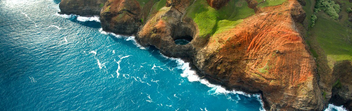
Mention Hawaii, and it conjures up thoughts of a tropical paradise. Pristine waterfalls, luxuriant creeping vegetation, and squawking, duck-like coots remind millions of annual visitors about the Creator’s handiwork.
The Hawaiian Islands’ landscape is a product of catastrophic forces unleashed by Noah’s Flood.
But red hot lavas slowly moving across fields and engulfing roads are never far away. Indeed, the Hawaiian Islands are a string of active and extinct volcanoes that hint at a catastrophic past. No Garden of Eden, this charming landscape is a product of catastrophic forces unleashed by Noah’s Flood. This modern-day “paradise” speaks unmistakably of God’s recent judgment.
If the volcanoes that formed Hawaii’s eight major islands had been formed before or during Noah’s Flood, the Flood would have deposited sediments on their flanks. But they have none. So we know the volcanoes must have erupted following the Flood.
So how did eight islands pop up in a neat row in the middle of the Pacific Ocean after the Flood, 3½ miles (19,297 feet, or 5882 m) above the surrounding seafloor? The origin of these gems gives us a fascinating window into the incredible tectonic forces that tore apart the planet during the Flood. Indeed, we now have enough geologic clues to begin reconstructing what took place in the Pacific while Noah’s family was landing on the mountains of Ararat and then settling the Near East.
Paradise Revisited
The Hawaiian Islands are an archipelago of eight major islands, numerous small islets, and undersea mountain peaks called seamounts (Figure 1). They extend in an arc some 1,500 miles (2,400 km) from the island of Hawaii (the “Big Island”) in the southeast to the Kure Atoll in the northwest. The total land area of the Hawaiian Islands is a mere 6,423.4 square miles (16,636.5 sq. km), small compared to the world’s largest archipelago—the Malay Archipelago—which includes 24,000 islands and covers a million square miles.
Figure 1—Rising Lava and a String of Pearls
The Hawaiian Islands are the last in a string of volcanic islands that arose as the Pacific Plate moved over a “hot spot” in the crust. At the end of the Flood, eruptions began to produce dozens of islands stretching over 3,600 miles (5,800 km). The hot spot currently sits under Hawaii’s Big Island. The first islands, called the Emperor Seamounts, were small and most never grew large enough to reach the ocean surface. Radiometric potassium-argon dating shows that these seamounts are oldest, and the Hawaiian Islands are youngest. These islands formed quickly, over a few years, not “millions of years.”
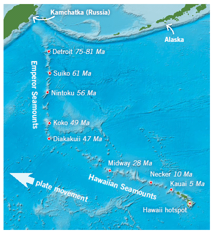
Illustration by Tasa Graphic Arts, Inc.
Yet the comparison is not fair. The Malay islands are made out of crust material from the nearby continents of Asia and Australia, while the Hawaiian Islands are made out of volcanic rock from the earth’s mantle. These volcanic islands are part of an even longer chain that extends all the way to Alaska. It is estimated that volcanic material in this chain would be enough to cover the entire state of California one mile thick. That was a lot of lava belching out of the earth in the past!1
The Big Island at 4,028 square miles (10,432.5 sq. km) is made up of five broad, rounded, still-active shield volcanoes, the tallest being Mauna Kea, which towers to 13,803 feet (4,207 m) above sea level. If measured from its base on the ocean floor, its height is 33,100 feet (10,100 m), making it taller than Mt. Everest! Its still-active neighbor Mauna Loa, just 120 feet (37 m) lower, is the largest volcano in the world, covering a land area of 2,035 square miles (5,271 sq. km).
Where Do the Lavas Come From?
The earth has an outer skin or crust, beneath which lies the mantle.2 Scientists believe the molten basalt that erupts from these huge volcanoes rises from the upper mantle. There is even evidence that a plume of hot rock is still welling up from the mantle and feeding the active volcanoes on the Big Island (Hawaii). This mantle plume has pushed up the ocean floor beneath Hawaii, forming a huge, shallow “blister” or swell over 620 miles (1,000 km) wide. Currently the most active volcano is Kilauea on the Big Island, but the newest volcano is the Loihi Seamount, just to the southeast of Hawaii.
Maui is the next largest island in size and the next in the chain. The islands quickly become smaller and smaller. Maui’s area is only 727.2 square miles (1,883.4 sq. km). Furthermore, its largest volcano, Haleakala, is only 10,023 feet (3,055 m) tall and is no longer active. Indeed, the volcanoes and the volume of lavas get progressively smaller as you progress along the chain toward the northwest.3
Intriguing Chains
This intriguing pattern does not end with the eighth island. Farther northward is yet another line of seamounts (undersea mountain peaks). Known as the Emperor Seamounts, this chain stretches another 2,100 miles (3,400 km) northward to Alaska’s Aleutian Trench (Figure 1). These seamounts are the remnants of former volcanoes but do not rise above the ocean surface. (Curiously, a few of these seamounts are flat-topped, implying they once were exposed above sea level and were eroded off.)
A very interesting pattern appears. The largest and active volcanoes are at one end. As you move northward along the chain, the past lava output and volumes become progressively less and the volcanoes smaller, until the volcanoes don’t even rise above the surface and are long dead. What caused this progression?
One clue is the relative ages of the rocks on the Hawaiian Islands and Emperor Seamount chains. Using the standard radiometric dating technique that measures the radioactive decay of potassium to argon (the potassium-argon method), we learn that the youngest volcanic rocks are on the island of Hawaii. (That’s what we would expect since its volcanoes are still active.) The volcanic rocks become progressively older northward along the chain. The central islands of Midway Island and Kure Atoll are said to be 28 million years old, and then the seamounts along the Emperor Chain date from 47 million years northward to 81 million years (Figure 1).While creationists strongly dispute the actual ages, they agree with the relative nature of the measurements (more later).
The Moving Pacific Plate
The discovery that the earth’s crust is broken into moving plates has provided us with an elegant explanation for the islands’ pattern. The Pacific plate (making up much of the floor of the Pacific Ocean) has been moving northwestward. As the plate moved over the essentially stationary Hawaiian mantle plume, the rising molten rock built a series of seamounts and islands in quick succession (Figure 2).
Figure 2—Hawaii Is a Hot Spot
Most of the world’s volcanoes form where crustal plates crash into each other, but Hawaii is different. It lies over a “hot spot,” or mantle plume, where hot material breaks through the thin ocean crust.
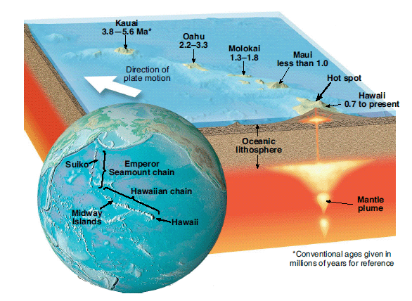
Illustration by Tasa Graphic Arts, Inc.
Radiometric dates show progressive “aging” from Hawaii (the youngest) to the seamounts (the oldest). These measure radiometric decay over months and years, not “millions of years (Ma).”
Thus the seamount at the northern end of the Emperor chain was formed first, when that point was over this “hot spot,” incorrectly dated by the faulty radiometric method at some 81 million years ago. As the plate moved, it eventually reached the position where it is today, with the island of Hawaii and the Loihi Seamount sitting on top of the mantle plume (Figure 2).
Old-earth, secular geologists say this plate movement has always been slow and gradual. To bolster their supposed case, they point to an interesting correlation. If you plot the radiometric ages of the different islands and seamounts against the distances from Kilauea, the rate of 2.6–3.6 inches (6.6–9.1 cm) per year just “happens to be” about the same as the plate movement today. However, if the plate motion had been uniformly slow at today’s rate, all the volcanic islands should have been of similar sizes.
As for the “bend” where the Emperor and Hawaiian chains meet, it is thought the direction of the Pacific plate’s motion changed, starting some “47 million years ago” according to evolutionary scientists. No one knows yet why this direction changed. Perhaps the answer will provide some new interesting insights. It has also been suggested, though, that before this “bend” occurred the “hot spot” may also have been moving slightly.4
Making Biblical Sense of the Evidence
So what are we to make of all this within the biblical framework for the earth’s history?
Creation geologists do not dispute that plate tectonics has occurred. However, they believe substantial evidence confirms that it occurred catastrophically during the Flood.5 Furthermore, as the Flood was waning, the plate motions decelerated from tens of feet (meters) per second to their current snail’s pace of only an inch or two (mere centimeters) per year. Any movement of the hot spot also would have ceased, while catastrophic outpourings of lavas from the hot spot rapidly decreased.
And this view makes even better sense of the observed evidence, such as the sizes of the recent islands, which grew bigger due to larger volumes of lavas. As the plates slowed, there would have been more time for the upwelling mantle “hot spot” to send up lavas, even if the eruptions decreased. Thus the island of Hawaii is much larger than the other islands.
In contrast, the plate was moving so rapidly when the Emperor chain was being formed that few of the volcanoes had time to grow big enough to breach the ocean surface.
Perhaps the plate began slowing down as it changed direction to produce the bend between the two chains. Only when the plate motion slowed was there enough time to build the Hawaiian Islands, even if the lava outpourings slowed to a comparative trickle.
Those Radiometric Dates?
But what about those potassium-argon millions-of-years dates? There are good reasons they must be regarded as greatly exaggerated.
Excess argon rises with the lavas from beneath the earth’s crust, contaminating them so that they yield excessively old dates.6 This volcanic argon gas does not arise from radioactive decay of the potassium in the rocks, but instead it is trapped in the basalts, making them “read” older. Furthermore, potassium-argon dates of volcanic rocks on seamounts can increase with depth underwater, regardless of actual age.7
This type of faulty assumption behind radioactive dating leads to exaggerated dates.8 Another crucial, unverifiable assumption made by evolutionary scientists is that the decay rate has been constant throughout time—that is, the radioactive “clocks” have always ticked at the same rate. But creation research has demonstrated that all the decay rates were grossly accelerated in the recent past, during the global Flood cataclysm.9
This finding indicates that, just as plates accelerated during the Flood and then decelerated, so radioactive decay rates accelerated, apparently in lockstep, and then decelerated. Thus the volcanic rocks that formed earlier as the Pacific plate moved over the “hot spot” yield exaggerated radioactive dates due to quickly ticking radioactive clocks. As the Flood ended, both plate motions and radioactive decay rates slowed. These are not true absolute dates because the “clock” was ticking faster than it does today.
God’s Judgment and Promise
So while the Hawaiian Islands today appear to be a tropical paradise, they were built during the aftermath of the Flood cataclysm. Not only were the tectonic plate motions and volcanic eruptions catastrophic, but even radioactive decay was occurring at catastrophic rates.
However, God mercifully ended His judgment by decelerating catastrophic processes, allowing time for the volcanic lavas to build today’s island paradise. Meanwhile, the occasional volcanic eruptions are a reminder of the islands’ catastrophic past and God’s promise never to flood the entire earth again.
holds a PhD in geology from the
University of Sydney and has worked as a consultant
research geologist in both Australia and America. Author
of numerous scientific articles, Dr. Snelling is now
director of research at Answers in Genesis–USA.
Answers Magazine
January – March 2014

Placed safely in our solar system’s “goldilocks zone” and engineered with the perfect balance of atmosphere, chemicals, and water, our earth was miraculously formed to be inhabited (Isaiah 45:18). This issue examines the earth’s unique suitability for life. We’ll also investigate what seminaries are actually teaching our pastors, the possibility that viruses could be beneficial, and more.
Browse IssueFootnotes
- http://geology.com/usgs/hawaiian-hot-spot/.
- A. A. Snelling, “Journey to the Center of the Earth,” Answers 8.3 (July–September 2013): 72–75.
- The flanks of the islands have also been reduced in size by giant landslides. Huge blocks (up to 20 miles long and 1 mile thick) lie on the ocean floor surrounding the islands. See J. Whitmore, “The Potential for and Implications of Widespread Post-Flood Erosion and Mass Wasting Processes,” in Proceedings of the Seventh International Conference on Creationism (Pittsburgh, Pennsylvania: Creation Science Fellowship, 2013).
- http://geology.com/usgs/hawaiian-hot-spot/
- S. A. Austin, J. R. Baumgardner, D. R. Humphreys, A. A. Snelling, L. Vardiman, and K. P. Wise, “Catastrophic Plate Tectonics: A Global Flood Model of Earth History,” in Proceedings of the Third International Conference on Creationism, R. E. Walsh, ed., (Pittsburgh, Pennsylvania: Creation Science Fellowship, 1994), pp. 609–621.
- For example, the potassium-argon dates obtained from the basalts of the 1800–1801 eruptions of Hualalai on Hawaii were 1.4, 1.6 and 22.8 million years, from the basalts of the Kilauea Iki eruption of 1959 on Hawaii, 8.5 million years, and from basalts erupted from Kilauea on Hawaii <200 and <1,000 years ago, 21 and 42.9 million years respectively. See: A. A. Snelling, “Geochemical Processes in the Mantle and Crust,” in Radioisotopes and the Age of the Earth: A Young-Earth Creationist Research Initiative, L. Vardiman, A. A. Snelling, and E. F. Chaffin, eds., (El Cajon, California: Institute for Creation Research, and St. Joseph, Missouri: Creation Research Society, 2000), pp. 123–304.
- G. B. Dalrymple and J. G. Moore, “Argon 40: Excess in Submarine Pillow Basalts from Kilauea Volcano, Hawaii,” Science 161 (1968):1132–1135; C. S. Noble, and J. J. Naughton, “Deep-Ocean Basalts: Inert Gas Content and Uncertainties in Age Dating," Science 162 (1968): 265–267.
- A. A. Snelling, “Radiometric Dating: Problems with the Assumptions,” Answers 4.4 (October–December 2009): 70–73.
- L. Vardiman, A . A. Snelling, E. F. Chaffin, eds., Radioisotopes and the Age of the Earth: Results of a Young-Earth Creationist Research Initiative (El Cajon, California: Institute for Creation Research, and Chino Valley, Arizona: Creation Research Society, 2005).


Support the creation/gospel message by donating or getting involved!

Answers in Genesis is an apologetics ministry, dedicated to helping Christians defend their faith and proclaim the good news of Jesus Christ.
- Customer Service 800.778.3390
- Available Monday–Friday | 9 AM–5 PM ET
- © 2025 Answers in Genesis