
Chapter 8
The Snowblitz
The Genesis flood provides the two ingredients necessary for an ice age. From this point on we can use basic meteorology to estimate the storm patterns and where ice sheets would develop.
The Genesis flood uniquely and providentially provides the two ingredients necessary for an ice age. From this point on we can use basic meteorology to estimate the storm patterns and where the ice sheets would develop. Because of the dynamic combination of cool summers in mid and high latitude continents adjacent to warm oceans, some areas would quickly develop an ice sheet. Other areas had to wait until the ocean cooled enough because warm onshore flow would keep some lands too warm. Surprisingly, some areas that at first sight appear ideal for glaciation would not be glaciated at all, such as the lowlands of Alaska and Siberia.
“Snowblitz” is a word used to describe how a large area becomes covered quickly with snow and ice. This contrasts with the idea that an ice sheet started in the high mountains of the higher latitudes and slowly crept southward at a glacial pace. The post-Flood Ice Age model reveals that the Ice Age developed over large areas all at once, immediately after Noah’s flood.1
Rapid accumulation of snow and ice
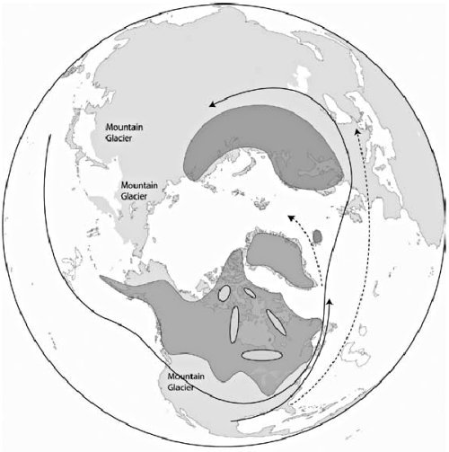
Figure 8.1. Distribution of snow and ice and storm tracks at maximum glaciation. Circular areas within the North American ie sheet represent postulated ice domes. Little sea ice has formed as yet. View full-size.
Most of the snow that fell during the Ice Age would have been associated with storms rather than as continuous snowfall. Understanding the location of the storm tracks is essential to predicting where the snow and ice first built up. In today’s climate, storms take a variety of paths, but because of the earth’s topography and general temperature patterns, storms favor certain areas. Presently, they develop most frequently around Iceland in the North Atlantic Ocean and in the Aleutian Islands in the North Pacific. These are called the Iceland and Aleutian lows, respectively.
During the Ice Age, storms also tended to favor certain paths. Because of strong temperature contrasts between land and sea, storms in the Northern Hemisphere would develop more frequently just south of the growing ice sheets and along the east coasts of Asia and North America (figure 8.1).2 It is important to remember that these storm tracks would be averages with a fair amount of chaotic storm tracks.
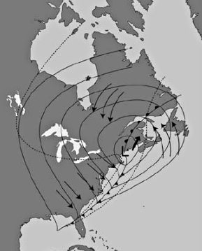
Figure 8.2. A northeaster storm that should be typical during the Ice Age, showing the areas of precipitation within the dotted line. Arrow north of low center (L) is the direction of movement. Multiple arrows are wind directions.
In the Northern Hemisphere most of the precipitation from snowstorms falls on the north and northwest side of the storm (see figure 8.2). This is the coldest part of the storm. With a main storm track just south of the developing ice sheets, the ice sheets would continue to grow, especially along the periphery. The first several years after the Flood, snow would have covered a large area of the continental interiors of the mid and high latitudes. The Ice Age would start as a snowblitz with snow blanketing large areas of Canada and the northern United States right away, and accumulating in many mountainous areas. The ice would not need to develop in northern Canada and move slowly into the northern United States.
As long as the volcanic ash and gases remained thick in the stratosphere, and the mid and high latitude ocean surface remained warm, the snow would continue to fall and would rapidly build up. There likely would be only minor summer melting early in the Ice Age, mainly along the edge of the ice sheets.
A number of minor climatic processes would either reinforce or dampen the cooling caused by the volcanic ash and dust in the stratosphere. One of these is snow-cover cooling. Once a snow cover is established, the temperature cools about another 10°F (6°C) because of snow’s greater reflectivity to sunlight. This reinforces the cooling already caused by volcanic ash and gases.
To keep the snow quickly and continuously accumulating, the sea surface temperatures must remain warm at mid and high latitudes. But, as rapid evaporation occurs from the ocean and cool continental air blows over the ocean, the ocean surface will cool. This creates a damping effect on evaporation. This is countered for a time by chilled surface water sinking and being replaced by warmer water from below. Additionally, an enhanced ocean circulation will continually feed warm water from further south into the higher latitudes (figure 8.3). So, the ocean surface temperatures will remain relatively warm for a long time at mid and high latitudes, despite the cooling effects, ensuring the high water vapor demanded for productive storms.
The Ice Age still had seasons due to the changing angle of the sun but would have cooler summers and milder winters. The seasonal contrast over continental areas would be much less than we see today, maybe on the order of 15°F (8°C).
The potential for rapid glaciation can be demonstrated by considering a famous type of storm from the east coast of North America — the northeaster (figure 8.2). These storms commonly dump a foot or more (25 cm or more) of snow. The storm of the century, on March 12–15, 1993, dropped up to 56 inches (140 cm) of snow in the eastern United States.3 Figure 8.4 shows a cross section through the northern part of a northeaster with warm moist air from the Atlantic Ocean rising up over a surface inversion with cold, dense air on land. In fact, I expect that an inversion occurred over most areas where the ice sheets developed with warm moist air overriding the cold air. Northeasters during the Ice Age would be more frequent and much stronger than what we experience today. They would generally produce in the neighborhood of three times the snowfall over twice the area, mostly because of the stronger temperature difference between the developing ice sheet and the warm ocean.
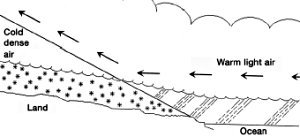
Figure 8.4. An atmospheric cross section through the northern part of a northeaster. The straight slanted line is the boundary between cold and warm air.
To show the potential of northeasters for a snowblitz, assume one northeaster every week for a year moved parallel to the East Coast, dropping 20 inches (50 cm) of snow in New England and southeast Canada. This is about twice the average for these types of storms, but it is a rather conservative figure considering the amount of water vapor available during the Ice Age. The ratio of snow to water is commonly 10 inches of snow to 1 inch of water. After the snow is converted to ice, this 20 inches of snow would become about 2 inches (5 cm) of ice. In the first year of the Ice Age, assuming no summer melting, 104 inches (264 cm) of ice would collect. If this rate continued for 200 years, the ice would be 1,733 feet (530 m) deep, more than enough for a developing Ice Age.
Assume that other storm tracks passed through southeast Canada and New England. In addition to the northeaster, there would be a main storm track that stretched parallel to the southern boundary of the ice sheet (see figure 8.1). This would have an overland path and would not contain as much water vapor as a northeaster that picks up its supply from the warm ocean off the east coast. In 200 years, the continental storm path could add another 500 feet (150 m) of ice. So, there is potential for as much as 2,200 feet (670 m) of ice to be deposited from these two main storm tracks in just a 200-year period.
The early ice sheets
A number of factors would contribute to the timing and spread of glaciation early in the Ice Age. The ice sheets would accumulate rapidly in the areas closest to the main storm tracks and the moisture source of the warm ocean. Glaciation would be delayed in areas that were too close to the warm ocean. The warm ocean heats the air above it and as this onshore flow of air spreads inland, it would keep the adjacent land relatively warm. This is why Seattle, Washington, rarely falls below freezing and rarely sees snow.
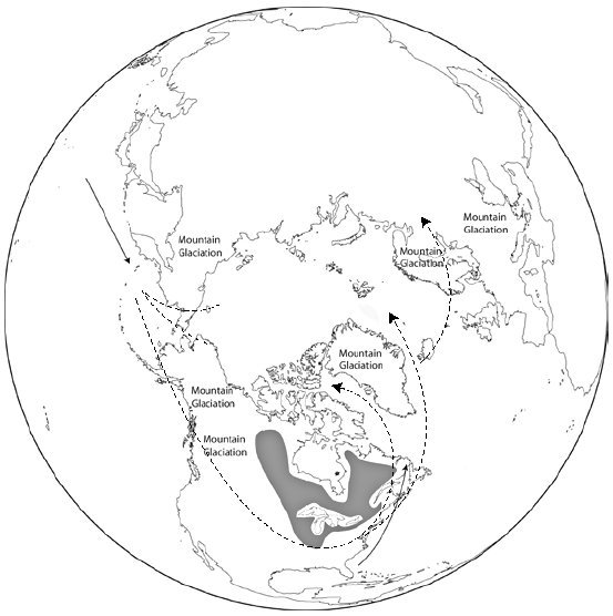
Figure 8.5. Postulated major (solid line) and minor (dotted line) storm tracks and snow cover in the Northern Hemisphere at the beginning of the post-Flood Ice Age. (Redrawn from Ruddiman and McIntyre.4) View full-size.
Figure 8.5 shows the estimated areas of early ice build-up. Southeast Canada and New England would lie in a very favorable area for rapid accumulation of snow and ice. That is probably why Labrador was one of the ice domes of the Laurentide ice sheet of central and eastern Canada (see figure 9.3 in chapter 9). The southern interior of Canada and the northern Midwest of the United States, being farther from the moisture source, would have had a relatively thin ice sheet at this time.
For a time, the lowlands of Scandinavia and British Columbia would be too warm for ice because of strong onshore airflow of relatively warm air. The mountains, however, would quickly develop thick ice caps that would tend to gradually descend into the valleys. Because of the warm Baltic Sea and North Atlantic Ocean, snow and ice build-up on continental Europe would be delayed. The British Isles, surrounded by warm water, would not be glaciated at all at the beginning. Greenland at this time would also be surrounded by warm water and would probably have snow and ice mostly in the mountains.
There would be an interesting distribution of snow and ice over the northern areas of the ice sheets, those lands bordering the Arctic Ocean. Remember that, right after the Flood, the Arctic Ocean would have no sea ice, as the water temperature would be quite warm. During the first several years of the Ice Age, this warm water would often be subject to cool air masses overriding it. This would cause strong evaporation. At the same time, the air would be heated up by contact with the warm ocean and the release of latent heat from the water vapor when it condensed. The warm air would keep the areas bordering the Arctic Ocean ice free at the beginning of the Ice Age. But the heavy moisture in the area would greatly boost snow and ice accumulation farther inland from the Arctic Ocean, a bit like the Donn and Ewing Ice Age theory (see chapter 6). This explains why the Keewatin portion of the Laurentide ice sheet, northwest of Hudson Bay, was an ice dome during the Ice Age (see figure 9.3 in chapter 9).
In contrast, the uniformitarian Ice Age model has great difficulty accounting for this ice dome. Donn and Ewing5 state the problem:
It is difficult to imagine a source of moisture for the maintenance of the prominent northwestward extension [to the Keewatin district] of the Canadian ice sheet in view of the pronounced barrier effect of the large Laurentide ice sheet to the south.
Today, the Keewatin area is one of the driest places in North America. During the Ice Age that uniformitarian scientists envision, Keewatin would be too far north to receive much precipitation. Uniformitarian scientists cannot postulate moisture from the Arctic Ocean because in their scenario this ocean would be covered with sea ice, but the ice-free warm Arctic Ocean in the post-Flood Ice Age model can account for the Keewatin ice dome.
The distribution of warm water immediately after the Flood has other interesting consequences. It is likely that the Great Lakes and Hudson Bay were large, warm bodies of water and would retard ice build-up over and close to them. Strong evaporation from these bodies of water would help build the snow and ice around them, but at some distance from their shores.
The area just east of the Rocky Mountains in North America would be unglaciated at this time because of warm air from the Pacific Ocean overriding the mountains and descending as mild chinook winds. This is called the ice-free corridor. The warm Arctic and North Pacific Oceans would also have kept most of Siberia and Alaska unglaciated at this time. It was warm enough in the lowlands of Siberia and Alaska and the ice-free corridor to allow all the animal migrations into the Americas during the early and middle part of the Ice Age. By now you are getting an idea as to why the woolly mammoths would be able to live in Siberia and Alaska during the Ice Age and why the lowlands would remain unglaciated.
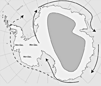
Figure 8.6. Postulated major (solid line) and minor (dashed line) storm tracks and snow cover (dark area) over Antarctica at the beginning of a post-Flood Ice Age. “Mtn Glac.” means mountain glaciation.
The Southern Hemisphere, with its huge warm ocean extending to the coast of Antarctica, would have a rather simple storm pattern. Since the warm water would abut the coast of East Antarctic, the main tracks would circle around this cold continent. This large land area would glaciate rapidly, especially when one considers all the warm water from the vast Southern Hemisphere oceans. West Antarctica would be more complicated. A significant portion of West Antarctica would still be a series of islands with warm water between. It is likely that early in the Ice Age, only the mountains of West Antarctica had ice caps (figure 8.6).
It is possible that a few of the higher mountain areas of the Southern Hemisphere and the tropics had ice caps early in the Ice Age, but these probably would be small until later.
The wet deserts
One major mystery of the Ice Age listed in chapter 3 is the evidence of large lakes, rivers, and the fossils of aquatic animals in current deserts and semi-arid areas. The Genesis flood and the Ice Age caused by the Genesis flood can easily account for the evidence of “wet deserts.”
Other than the main storm tracks shown in figure 8.1, it is challenging to predict the atmospheric circulation during the Ice Age. It is this circulation that also determines the precipitation on the planet. This is because warm ocean water and atmospheric evaporation strongly influences the atmospheric circulation. The effect of so much moisture injected directly into the air above the ocean and the release of latent heat spread around the Northern Hemisphere is difficult to compute. Having the continents cold with a small seasonal contrast adds to the difficulty because it is so different from today. No computer simulations of the atmosphere have been performed with anything close to these conditions. Larry Vardiman6 from the Institute for Creation Research has done some work with a simple climate model using a warm ocean and discovered many unique possibilities. These are suggestive of atmospheric patterns significantly different than today. Storm tracks, heavy precipitation belts, monsoons, and other climatic features would be unique to this Ice Age era. Perhaps in the future a sophisticated ocean-atmospheric climate simulation of the Ice Age can be executed.
One thing that can be stated is that such a unique Ice Age climate would cause much more precipitation all over the earth, simply because of the greater evaporation from a warm ocean. Furthermore, this precipitation would be distributed differently than it is today. This climate has the potential to cause copious precipitation in currently arid and semi-arid areas, such as the southwest United States. Of course, all the water in the lakes in the southwestern United States did not need to come from heavy Ice Age precipitation. As the Flood waters drained off the continents, while the land rose at the end of the Flood, water would be trapped in basins that had no outlet. The precipitation during the post-Flood Ice Age simply maintained the lakes left over from the Flood. Evidence for the maintenance of these lakes is shown by beaches that have been carved into terminal moraines near Mono Lake, California, and at the edge of valleys along the Wasatch Range of central Utah (figures 8.7 and 8.8).
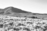
Figure 8.7. Shorelines carved into a terminal moraine when Mono Lake was much higher during the Ice Age.
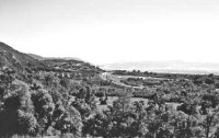
Figure 8.8. Shoreline of Lake Bonneville on moraine at the mouth of Little Cottonwood Creek and Bells Canyons, Wasatch Mountains, Utah.
The Sahara Desert is another good example of a “well-watered desert.” It had a fairly wet climate for several hundred years. This provided a healthy, flourishing environment for the people and animals that inhabited the area.
At the end of the Ice Age, mainly during deglaciation, a great desiccation occurred, producing the deserts and semi-arid areas we observe today. It is important to note: a post-Flood Ice Age has the potential to explain wet deserts, while the uniformitarian model with cold Ice Ages has great difficulty.
Frozen in Time

Author Michael Oard gives plausible explanations of the seemingly unsolvable mysteries about the Ice Age and the woolly mammoths.
Read Online Buy Book
Master Books has graciously granted AiG permission to publish selected chapters of this book online. To purchase a copy please visit our online store.
Footnotes
- Oard, M.J., An Ice Age Caused by the Genesis Flood, Institute for Creation Research, El Cajon, CA, pp. 38–65, 1990.
- Ibid., pp. 46–55.
- Oard, M.J., The Weather Book, Master Books, Green Forest, AR, p. 56–57, 1997.
- Ruddiman, W. F., and A. McIntyre, Warmth of the subpolar north Atlantic Ocean during Northern Hemisphere ice-sheet growth, Science, 204(4389): 173–175, 1979.
- Donn, W.L., and M. Ewing, The theory of an ice-free Arctic Ocean; in: The causes of climatic change, J.M. Mitchell Jr. (Ed.), Meteorological Monographs 8(30), American Meteorological Society, Boston, MA, p. 102–103, 1968.
- Vardiman, L., Climates before and after the Genesis flood: Numerical models and their implications, Institute for Creation Research, El Cajon, CA, p. 81–92, 2001.

Support the creation/gospel message by donating or getting involved!

Answers in Genesis is an apologetics ministry, dedicated to helping Christians defend their faith and proclaim the good news of Jesus Christ.
- Customer Service 800.778.3390
- Available Monday–Friday | 9 AM–5 PM ET
- © 2026 Answers in Genesis