
Noah’s Lost World
Noah’s world looked nothing like the continents today. With the help of geology, we can put many pieces back together.
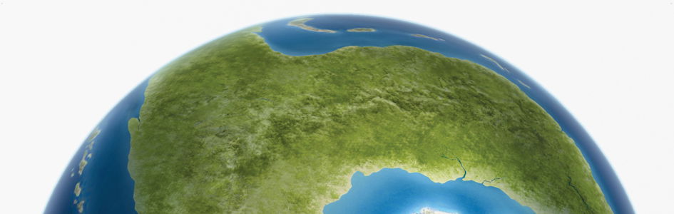
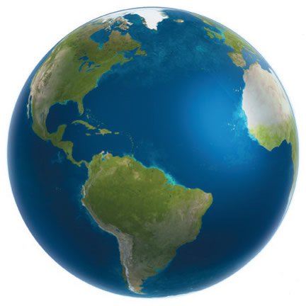
The world that we see today is not the one that existed in Noah’s day (2 Peter 3:6). That land was destroyed. In fact, it appears that the original continent was broken up and the pieces separated by thousands of miles.
If true, Noah never walked along the Santa Cruz Mountains and looked out over the scenic San Francisco Bay. He never hiked along the Apennines and gazed down upon the panoramic Mediterranean Sea. There were no Alps, Rockies, or snow-covered Himalayas; no Mississippi River rolling down into the Gulf of Mexico; no Amazon spilling into the Atlantic. The geography of the pre-Flood world was completely changed.
We get a glimpse into this different world in Genesis 1:9–10. On Day Three of the Creation Week, God gathered the waters together into “one place,” separate from the dry land. Somewhere on this land was a lovely place called Eden, out of which four great rivers flowed (Genesis 2:8–10). Nothing like that exists today.
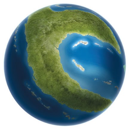
It appears that the whole planet was different. For example, if Noah stood in the spot where San Francisco was later built, he probably looked out over the warm landscape of Antarctica, or perhaps Australia, since no water then separated these land masses. That’s just one of the many differences. But how can such things be possible?
Geologists have stumbled across tantalizing clues that allow them to begin reconstructing the sequence of events necessary to produce the dramatic features on earth today. This ongoing work is exciting for creationists. Though the details are fragmentary, a picture is emerging of what may have been the supercontinent Noah lived on.
These findings point to Scripture, which makes much better sense of the catastrophic evidence than slow processes over millions of years. They also remind all of us about God’s terrifying judgment against sin. We are without excuse.
Continental Fragments from an Earlier Time
Have you ever wondered what Noah’s world was like before the Flood? The fragments that survived the Flood make it possible to begin piecing together the puzzle, at least in broad terms.
Evidence indicates that the continents have moved around, broken apart, and crashed together, but the basic pieces have remained fairly constant. Violent catastrophes tore off slivers from the edges of the continents, but the core pieces seem to have survived.
Geologists call the cores of these pieces “cratons.” They seem to have remained stable throughout history. At one time they appear to have been joined together, but violent forces—unleashed during the Flood—tore them into many fragments.
The core of North America appears to be one of these cratons. In fact, most geologists believe it was a major component of the early earth’s supercontinent.
Moving Around the Pieces
Rodinia
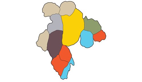
Original Supercontinent
(made of cratons)
Our modern continents are made out of pieces from the original earth, which broke apart during the Flood. These core pieces are called cratons. Certain features within these pieces and on their edges can be lined up, helping us put them back together. We call this original continent Rodinia, but so much has been lost that many puzzles remain.

Pangaea
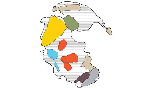
Temporary Supercontinent
(made of original cratons and Flood sediments)
After the original continent broke apart during the Flood, the pieces crashed together temporarily, forming a supercontinent known as Pangaea. How do we know this? The pieces were already covered with fossil-containing sediment layers when they crashed together. In the impact zones, these layers were pushed into folded mountains that we still see today.
Today
Modern Continent
(made of original cratons and sediments)
Today the earth consists of many separate continents, formed out of pieces from the first supercontinent. Only the cores survived. The rest of our modern continents were filled in by mud and sand that the Flood stripped from the earth’s surface. Geologists are studying the original pieces to see how the edges originally aligned.
Coastlines of a Super Continent?
One of the biggest clues for the original configuration of continents is evident on any world map.
In 1859 creationist geologist Antonio Snider-Pellegrini noticed the jigsaw puzzle fit of North and South America with Europe and Africa if the Atlantic Ocean basin were closed up.1 He also read Genesis 1:9–10 and realized that the landmass God formed on Day Three of the Creation Week was probably a supercontinent. Then that supercontinent broke apart during the Flood and continental sprint opened up today’s Atlantic Ocean.
Thus was born the catastrophic plate tectonics model, which provides a physical mechanism for the Flood.2 At the initiation of the Flood the fountains of the great deep were broken up (Genesis 7:11), ripping apart the pre-Flood supercontinent. The upwelling molten rock from the underlying mantle then helped to propel the continental fragments across the globe, opening up new ocean basins and colliding to produce today’s mountains.
Much geologic data is consistent with this scenario, although the rapid movement of plates is a separate topic.3 By locating the remnants of the original pre-Flood supercontinent we can project the movements of those fragments back to their original positions to potentially reassemble Noah’s lost world.
Pangaea Was Not Noah’s Lost World
However, there is a complication that has sometimes caused misunderstandings. The supercontinent Snider-Pellegrini reconstructed became known by geologists as Pangaea (sometimes spelled Pangea), after the ancient Greek words pan meaning “entire” and Gaia meaning “Mother Earth.” We now know Pangea could not have been the pre-Flood supercontinent. Something must have occurred earlier to produce the features on Pangaea.
When we remove the Atlantic Ocean and put the pieces back together again, we find a long mountain chain that ran from North America through Europe. The problem is that this chain, known as the Appalachian-Caledonian mountains, is made out of fossil-bearing sediments that were deposited earlier during the Flood. The only known way to form a mountain chain like this is for one continent to collide with another continent. This means that the Flood had to deposit fossil-bearing layers in North America and Europe before they crashed into each other to form Pangaea.
Thus Pangaea cannot have been the pre-Flood supercontinent that Noah lived on. It could only have been a temporary merger of continental fragments during the Flood, lasting no more than a few weeks. Pangaea was a supercontinent during the Flood, but it was completely underwater.
How Do We Know Pangaea Is Not the Created Continent?

Today’s continents were once joined together because some mountain chains, such as the Appalachians (US) and Caledonians (UK and Scandinavia), are now separated by thousands of miles. But these mountains were not on the original supercontinent because they are made out of Flood deposits.
The only way such mountain chains could form is for the original supercontinent to break apart, the plates get covered by layers containing dead animals, and then crash together temporarily. As these plates moved again, they took with them pieces of the mountain chain formed by the collision, one piece in the US and one piece in the UK and Scandinavia.
Clues to Realign the Pre-Flood Continental Fragments
Today geologists are trying to identify the edges of the continental fragments (or cratons), and then line them up in their original configuration. This helps them reconstruct the appearance of the original landmass.
Even though there is speculation, some reliable clues exist to aid geologists.
The Pangaean rearrangement is generally agreed on, but speculation increases as we go further back in time. For example, secular geologists find rock layers with large salt and sand deposits and assume these came from deserts that were close to the equator. However, Flood geologists know those sand layers were deposited underwater, apparently stripped from postulated coastal beaches around the world at that time.
Even though speculation increases the further we go back in time, several reliable clues have come to geologists’ aid.
Paleomagnetism
One clue is called paleomagnetism. Don’t let the term intimidate you. Since the earth has a magnetic field, minerals that are magnetic will tend to line up with the earth’s magnetic poles. Whenever lava cools, for instance, those minerals will align themselves with the points of the compass.
Once the rocks harden, geologists can use their alignment to determine the latitude where the rocks formed. If the landmass is moving quickly over hundreds of miles, different lavas will align in different magnetic directions as they harden.
Rock Types
Another clue is the physical content of the rocks. There are thousands of different types of rocks, such as huge piles of certain basalt lavas that can be matched between some continents, and hundreds of ways to measure different rock contents, including the type of fossils they contain and the radioactive decay within certain minerals. Based on these clues, geologists can often determine which large deposits once lay next to each other, even after they have moved thousands of miles apart.
Debris Deposits
Perhaps the most significant clue to line up the continents is the type of sedimentary rock layers that the Flood initially deposited at the edges of the cratons. These deposits, just above the “basement” rocks, have some distinctive characteristics that can be lined up between continents.
The basement rocks do not have multicellular fossils in them. They appear to be the originally created rocks, and sediment layers deposited in the pre-Flood world. The remnants are all that we have left after the Flood waters shaved off the surfaces of the continents.4 The boundary between the pre-Flood and Flood rocks usually has a distinctive erosion surface, sometimes associated with huge broken fragments of rocks.
The huge fragments, sometimes measuring up to two-thirds of a mile across, represent places where the edge of the pre-Flood supercontinent collapsed at the initiation of the Flood.5 Huge slabs broke off and cascaded down into deeper waters. The initial Flood sediments then piled up on top of these debris deposits. The same deposits can be traced along the edge of the pre-Flood North American fragment.6
Others have also noticed these same debris deposits at many other places around the globe at the same level in the strata sequence.7 They help define the edges of the pre-Flood supercontinent.
The Pre-Flood Super Continent Rodinia
So is there geologic evidence of an earlier supercontinent, which broke apart and its fragments subsequently collided and coalesced together to form Pangaea, which then broke apart into today’s continents that sprinted into their present positions? Yes! This earlier supercontinent, which was thus likely Noah’s lost world, has been called Rodinia (from the Russian word rodina, meaning “The Motherland”).
What then did Rodinia look like? Geologists are fairly certain about the basic configuration of the core cratons, but they are still unsettled about many of the details. There are multiple ways to fit together the fragmentary continental pieces of the puzzle. Remember, we are looking at scattered, damaged, and altered rocky remnants of the pre-Flood world.
Several reconstructions of Rodinia have been published.8 Yet all consider the North American fragment to be the central piece of the puzzle, and Australia and Eastern Antarctica are placed along the western edge. So far, nobody can agree on how much of the edges are missing, or the precise location of some fragments, such as South China or Australia.9 Reconstructing Noah’s lost world is very complex. No reconstruction is yet able to produce the one coherent supercontinent from all the fragments. All such reconstructions must have an element of speculation because so much was destroyed by the Flood cataclysm.
But we do have a reasonable picture of what happened at the catastrophic initiation of the Flood. Huge plumes of molten rock blasted the underside of the earth’s crust like massive blow-torches.10 Eventually the crust was ripped apart, and steam and molten rock burst forth. The supercontinent collapsed, with slivers of land sliding into the ocean at the margins.11 It must have been horrific.
The one certainty we have about the pre-Flood world is the Creator’s brief eyewitness account given in His Word. We have forever lost the world where Noah lived; it was ripped apart and wiped away by the global Flood cataclysm. The surviving clues should be a sober reminder of the warning by Jesus Christ, the Creator Himself: when He comes again to judge all mankind, circumstances will resemble Noah’s day, when “the Flood came and took them all away” (Matthew 24:37–39).
holds a PhD in geology from the University of Sydney and has worked as a consultant research geologist in both Australia and America. Author of numerous scientific articles, Dr. Snelling is now director of research at Answers in Genesis–USA.
Answers Magazine
April – June 2014

A closer look at the Genesis Flood account reveals a beautifully written, unified narrative that points to one inspired author. The passage masterfully highlights one central message: “God remembered Noah.” Along with in-depth articles on the Flood, this issue shows biblical and historical evidences of Christ’s Resurrection, new discoveries about the miracle of a butterfly’s metamorphosis and much more!
Browse Issue SubscribeFootnotes
- A. Snider-Pellegrini, La Création et ses Mystères dévoilés (Paris, France: A. Frank et E. Dentu, 1859).
- S. A. Austin, J. R. Baumgardner, D. R. Humphreys, A. A. Snelling, L. Vardiman, and K. P. Wise, “Catastrophic Plate Tectonics: A Global Flood Model of Earth History,” in Proceedings of the Third International Conference on Creationism, R. E. Walsh, ed. (Pittsburgh, Pennsylvania: Creation Science Fellowship, 1994), pp. 609–621.
- A. A. Snelling, “Geophysical Issues: Understanding the Origin of the Continents, Their Rock Layers and Mountains,” in Grappling with the Chronology of the Genesis Flood, S. W. Boyd and A. A. Snelling, eds. (Green Forest, Arkansas: Master Books, 2014), pp. 111–144.
- S. A. Austin and K. P. Wise, “The Pre-Flood/Flood Boundary: As Defined in Grand Canyon, Arizona and Eastern Mojave Desert, California,” in Proceedings of the Third International Conference on Creationism, R. E. Walsh, ed. (Pittsburgh, Pennsylvania: Creation Science Fellowship, 1994), pp. 37–47.
- R. Sigler and V. Wingerden, “Submarine Flow and Slide Deposits in the Kingston Peak Formation, Kingston Range, Mojave Desert, California: Evidence for Catastrophic Initiation of Noah’s Flood,” in Proceedings of the Fourth International Conference on Creationism, R. E. Walsh, ed. (Pittsburgh, Pennsylvania: Creation Science Fellowship, 1998), pp. 487–501.
- V. Wingerden, “Initial Flood Deposits of the Western North American Cordillera: California, Utah and Idaho,” in Proceedings of the Fifth International Conference on Creationism, R. L. Ivey, Jr., ed. (Pittsburgh, Pennsylvania: Creation Science Fellowship, 2003), pp. 349–358.
- They often have warm water limestone deposits associated with them, so the interpretation that they are glacial deposits is wrong. Z. X. Li, D. A. D. Evans, and G. P. Halverson, “Neoproterozoic Glaciations in a Revised Global Paleogeography from the Breakup of Rodinia to the Assembly of Gondwanaland,” Sedimentary Geology 294 (2013): 219–232.
- D. A. D. Evans, “Reconstructing Pre-Pangean Supercontinents,” Geological Society of America Bulletin 125 (2013): 1735–1751.
- Where to put the Australian pre-Flood remnant in relation to the North American fragment is quite disputed. A link with the Southwest U.S. is called the SWEAT connection; see I. W. D. Dalziel, “Global Paleotectonics: Reconstructing a Credible Supercontinent,” Geological Society of America Bulletin 109 (1997): 16–42. Others link it with the western U.S. (the AUSWUS connection); see K. E. Karlstrom et al, “Refining Rodinia: Geological Evidence for the Australia-Western U.S. Connection in the Proterozoic,” GSA Today 9 (1999): 1–7. Others link with Mexico (the AUSMEX connection); see S. A. Pisarevsky et al, “Models of Rodinia Assembly and Fragmentation,” in Proterozoic East Gondwana: Supercontinent Assembly and Breakup, M. Yoshida, B. F. Windley and S. Dasgupta, eds. (Geological Society of London Special Publication 206, 2003), pp. 35–55. Others add a “missing link” that eroded away; see Z. X. Li et al, “Assembly, Configuration and Break-up History of Rodinia: A Synthesis,” Precambrian Research 160 (2008): 179–210.
- Ref. 8 and A. Johansson, “From Rodinia to Gondwana with the ‘Samba’ Model—A Distant View from Baltica Towards Amazonia and Beyond,” Precambrian Research (2013), http://dx.doi.org/10.1016/j.precamres.2013.10.012.
- Ref. 2.
Support the creation/gospel message by donating or getting involved!

Answers in Genesis is an apologetics ministry, dedicated to helping Christians defend their faith and proclaim the good news of Jesus Christ.
- Customer Service 800.778.3390
- © 2024 Answers in Genesis