

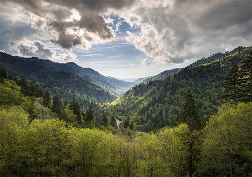
The view from Clingmans Dome in the Great Smoky Mountains National Park
Making More of the Mountains
by
Dr. Andrew A. Snelling
on
June 24, 2018; last featured
April 21, 2024
Featured in Answers Magazine
The Smoky Mountains offer much more than breathtaking vistas and vacation getaways. The hills resound with a symphony from the rocks, testifying to God’s creation of the world and the global Flood.
When you hear the words Smoky Mountains, what images come to mind? Black bears and rustic cabins in the woods? Hillbilly Golf and funnel cakes in Gatlinburg, in eastern Tennessee? Variety shows with twangy southern music and kids in racoon hats at amusement parks like Dollywood? With over half a million acres of hardwood forests, the Great Smoky Mountains region is one of the most popular tourist destinations in the southeastern United States, famed for its backwoods culture.
As a creation geologist from Australia, I didn’t hear about the Smokies until I visited the United States to do research. A fellow geologist recommended the Smokies as a good place to sample rocks for an idea I wanted to test. My goal was to verify that certain rocks in the earth’s mountain ranges formed quickly (even in weeks!), not over millions of years. In my area of expertise, I knew that within a certain mineral there are telltale byproducts if the rocks formed rapidly. I just needed to find some of that mineral in rocks that formed under the right conditions.
I found myself driving down the winding two-lane Highway 441—the only paved road cutting through these mountains on the border between Tennessee and North Carolina. Other people were passing me on their way to see shops in Gatlinburg or scenic overlooks like Clingmans Dome, the highest point on the Appalachian trail, 6,643 feet (2025 m) in elevation. Meanwhile, I was pulling over at various roadcuts and waterfalls. At these locations, all the trees and soil have been cleared out of the way, exposing the underlying rocks.
Geologists look at the world differently. We joke among ourselves that biology is something that covers up the good stuff, the rocks. Seriously, even if geology isn’t your calling, knowing a few basic things can transform how you view the world. You’ll never see the Smokies the same again. They’re full of evidence of God’s recent creation and the global Flood.
And by the way, I had to find out that the mountains’ name does not derive from smoke from fires hanging over them. In the warmer months droplets of mist in the air, combined with vapors from resins and plant oils rising from the lush vegetation, and wisps of fog, cause the natural “smoke” that gives the Great Smokies their name. The gently swirling rise and fall of the haze under varying conditions of temperature and light produces a bluish-gray smoke effect around the summits and in the valleys.
Ancient Hills?
The standard evolutionary story, presented at the Great Smoky Mountains National Park visitor centers, is that these rolling hills are very ancient, eroded down to bedrock over hundreds of millions of years. They’re not like the Rockies, which rise dramatically and still have sharp edges because—we are told—they are younger and haven’t had as much time to wear down.
A creationist sees these hills differently, based on the Bible. Every detail of the landscape makes sense within the Bible’s 6,000-year time frame, from the Smokies’ broad vistas—row upon row of blue-tinted ridges stretching as far as the eye can see—down to the individual rocks and the microscopic crystals inside them.
I see the same processes at work as other geologists, but I believe they occurred at a much faster pace in the past, especially during two unique events revealed in God’s Word—the six-day Creation and the yearlong Flood. The Apostle Peter says the Lord originally made the earth out of water and then “destroyed” it in a global Flood (2 Peter 3:6), forming a new world out of the raw materials, including mountain chains we see today. You just have to know what you’re looking for.
Here’s a basic geology term—metamorphic rocks. You first came across it in a science class that you have possibly forgotten if your teacher didn’t connect such terms to reality. Geologists believe that the Appalachian Mountain chain (which includes the Smokies) consists of sandy ocean sediments about ten miles thick that were transformed when Africa’s tectonic plate moved northward and rammed into the southeastern edge of North America. That hammer blow “crumpled” up the sediments to form the Appalachians.
The heat and pressure caused by smashing up these rocks changed (“metamorphosed”) the mineral compositions of the rocks. It’s like the metamorphosis of a caterpillar into a butterfly—the rocks are changed. That’s why we call them “metamorphic rocks.”
As I drive through these mountains, I envision the massive earth-shaping events that laid down all this sandy material and then reshaped it when continents collided during the Flood.
Like other creation geologists, I believe the original earth was a single supercontinent that broke into tectonic plates during the Flood, and then these pieces moved around rapidly, smashing into each other before slowing down to a crawl in their current locations.
If this is a correct interpretation of the evidence, the earth’s great mountain chains resulted from catastrophic forces unleashed during the Flood. Yet each mountain chain has its own special story, depending on its unique circumstances.
The evidence indicates that sediment layers making up the Appalachians formed early in the Flood, and the Appalachian Mountains formed soon after. The powerful currents that circled the globe (from east to west) then shaved several miles of rock material off the top of this chain, exposing the deep layers we see today.
That’s what I see when I visit the Smokies! They aren’t reminders of God’s creation, but of a worldwide judgment that produced “beauty out of ashes” (see Isaiah 61:3).
Colliding Continents
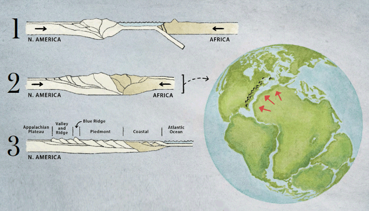
Illustration by Ben Iocco
The Appalachian Mountains can be explained by the earth’s catastrophic breakup into tectonic plates during the Flood. (1) Africa crashed into North America. (2) The collision crumpled up a mountain chain and formed a temporary supercontinent called Pangaea. (3) The raging Flood currents eroded these mountains, even as they formed.
When Continents Collide
The bulk of the Smokies consists of rocks made of sand (sandstone) that was changed under pressure by colliding continents. Forces in some places were more intense than in others. I was looking for just the right place where the combination of temperature, pressure, and water would have produced the telltale markers of rapid transformation.
I don’t expect you to get excited about the details of rocks and my experiment. Yet any Christian can get excited about seeing evidence of the great power that God displayed during the Flood and then telling others what God has done.
As you drive along Highway 441, you can easily imagine several miles of rock above your head as it is squished between two colliding continents, and then roaring ocean currents scrape off the top layers. You can also imagine how the impact produced the ridges we can see today.
The rocks themselves are interesting, however. They’re basically made of sands, which compose the lowest sediment layers in the local geologic column (known as Precambrian).
The rocks below them are known as “bedrock”—they are made of earlier sediments that were intensely metamorphosed when molten material rose from deep in the earth and hardened. At the Grand Canyon, you must descend a mile into the canyon to see these lower layers. But at the Smokies, you drive over the mountains to see them. How is this?
When the African plate crashed into North America, it pushed up the lower layers. You could never see these lower layers unless some extraordinary earth movement pushed them upward (or a canyon was cut deep into the earth like at the Grand Canyon). The map below shows the places I stopped to take rock samples.
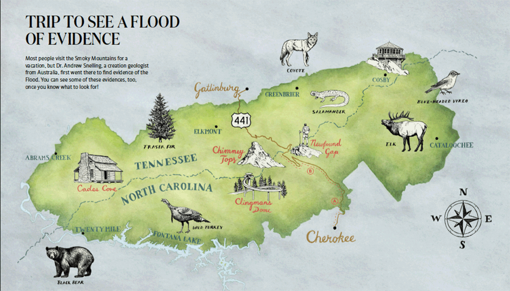
Illustration by Ben Iocco, (Click image for larger view.)
1. Cades Cove
Cades Cove, the most popular destination in the park, is a beautiful valley with historic log cabins and barns. The valley floor consists of limestone formed during the Flood (which is now deeply weathered), one of the few locations Flood deposits are exposed. The surrounding hills are made of pre-Flood rocks (look for gray, coarse sandstone), pushed up when Africa rammed into North America during the Flood.
2. Newfound Gap
Newfound Gap is the lowest opening through the Smoky Mountain chain. The open view offers the most spectacular mountain vistas in the park. Like most of the rocks in the park, the sandstones near the overlook belong to the Ocoee Supergroup, which existed before the Flood but got crumpled when continents collided.
3. Clingman’s Dome
The highest point on the Appalachian Trail is 6,643 feet elevation. An observation tower provides 360-degree views of the rolling, forest-covered mountains formed during the Flood when continents collided. Look for gray rocks with coarse white grains around the parking lot and along the hiking path. They’re pre-Flood Thunderhead Sandstone, metamorphosed by the continental collision.
4. Chimney Tops
Chimney Tops is named for its unique dual-humped peak, one of the few bare summits in the Smokies. These pre-Flood rocks were pushed up and metamorphosed during the Flood. As these rocks weathered over the centuries, this harder capstone (made of slate, not sandstone) remained.
Most people visit the Smoky Mountains for a vacation, but Dr. Andrew Snelling, a creation geologist from Australia, first went there to find evidence of the Flood. You can see some of these evidences, too, once you know what to look for!
Dr. Snelling’s Survey Trip
In 2004, geologist Andrew Snelling drove down Highway 441 for the first time, looking for evidence of the Flood. He wasn’t looking at the mountains, per se, but the rocks. Literally. He stopped along the side of the road to gather samples.
- Near Cherokee, he found basement rocks from Creation Week.
- Toward the crest he found what he was looking for—a zone of sandstone that had unique characteristics, which could be explained only if the mountains formed very quickly, not long ago.
First Stop: Granites
If you start your trip in Cherokee, North Carolina, you see “basement” rocks all around you. I took some samples just to contrast their minerals with the sandstone that I would find higher up.
These rocks form the foundation on which all the other strata have been deposited. While we cannot be certain about the details, it is apparent from the description in Genesis 1 that on Day Three of the Creation Week there was a tremendous geological upheaval. God uplifted rocky materials from under the universal ocean of the first two days of Creation Week to form the dry land surface on which he then created the plants. As he gathered the waters together in one place, he may well have gathered the emerging land surface into one place to make a supercontinent. Those rocks would have been folded and metamorphosed under pressure and elevated temperatures, accompanied by volcanic activity and molten rocks during this “Great Upheaval.”
Second Stop: Sandstone Under Heat and Pressure
The next stops were the focus of my study (see map). I wanted to visit the places where the crashing continents crumpled the sandy layers and the pressure was most intense.
As I stated earlier, it is estimated that nearly ten miles of fine- to coarse-grained sandstones were deposited on top of the basement rocks. That’s layers of nothing but sandstone between 25,000 and 50,000 feet thick. By far the thickest and most massive and prominent portion of these formations is the Thunderhead Sandstone, which is exposed in numerous roadcuts and waterfalls. Where did all this sand come from?
During the “Great Upheaval” on Day Three of the Creation Week, as the earlier rocks were brought together and uplifted to form the original supercontinent and then rose above the ocean waters, the water running off that supercontinent may have heavily eroded the emerging rocks. Enormous volumes of ground-up particles would have been swept away and deposited as sediments at the margins of the exposed supercontinent. Sedimentation would have continued, but at a much slower rate, until the Flood.
When the Flood began, that supercontinent was torn apart as the fountains of the great deep broke up (Genesis 7:11). As the continental fragments (plates) then “sprinted” across the globe it was inevitable some would collide with one another. Thus, Africa collided with North America.
This brief union of Africa and North America during the Flood formed a temporary supercontinent known as Pangaea. This lasted no more than a month or so (and most of it would have been underwater). The Smokies became the crest of a great mountain belt that stretched across Pangaea.
These rocks were metamorphosed. Depending on their location, the rocks display varying minerals that reflect different degrees of heat and pressure and different amounts of produced water. If I found the right place, I predicted that I would find the mineral in the rocks that, under a microscope, would have a combination of traits that wouldn’t be like those in any other rocks.
The science is complicated, and it’s not the main point here. (I’ve covered it in previous articles in this magazine and in our Answers Research Journal—search for my name and “polonium radiohalos.”) The tiny mineral I was looking for is called biotite (the dark, shiny specks you often see in granite countertops). If the temperature was too high, the “markers” I was looking for would have faded away, or if the temperature and water flow through the minerals in the rocks were too low, the markers wouldn’t even get produced.
Guess what. I found what I was looking for! These markers had to form in just days, not millions of years. Here’s a shorthand version of what happened. Radioactive uranium occurs in certain minerals in some rocks. As it decays, it produces another short-lived radioactive element (polonium) that leaves telltale blotches (radiohalos) in biotite flakes when it decays. These blotches could only occur during a short window of time (a matter of weeks) under just the right conditions, when the cooling rocks were hot enough to cause a particular reaction but not too hot to destroy the evidence.
You’ll need to read the other articles for the details. But the exciting truth is that these mountains declare the glory of God—consistent with Scripture—whether you consider the large-scale rolling hills or each tiny mineral under a microscope.
Third Stop: The Mountaintops
The rapid movement of continental plates lasted only a brief time. The rocks eventually cooled, and the rare chemical changes ceased. Powerful ocean currents then swept away the deposits on top of these sandstones (so later geologists could find them!).
As I drove to my final stops beyond the crest of the mountain chain to take samples, I didn’t expect to find the markers that I had found earlier. And those final samples matched my predictions too.
The view from Mortons Overlook, near Newfound Gap in Great Smoky Mountains National Park, Tennessee
When I was finished, I visited some of the popular scenic spots along the crest—Newfound Gap and Clingmans Dome. I looked out over the rolling hills and marveled at the evidence of what my Creator and Judge has done. Today the only force shaping the Great Smoky Mountains landscape is the slow action of rain, wind, chemical weathering, and streams. Thankfully, God has kept his promise never again to send an earth-destroying catastrophe like the one-time Flood (Genesis 9:11).
The evidence is all around us, if we have the faith in God to build our understanding on the solid rock of his Word. Such awe-inspiring vistas should bring to our lips the words of the psalmist, King David, “O Lord, our Lord, how majestic is your name in all the earth!
” and cause us to meditate on his exclamation, “What is man that you are mindful of him, and the son of man that you care for him?
” (Psalm 8:1, 4, 9).
holds a PhD in geology from the University of Sydney and has worked as a consultant research geologist in both Australia and the US. Author of numerous scientific articles, Dr. Snelling is now director of research at Answers in Genesis–US.
Answers Magazine
July–August 2018

Skeptics claim that a wooden ship the size of Noah’s Ark couldn’t possibly stay afloat. Did God perform a miracle to keep it from sinking? How could Noah’s Ark survive the storm?
Browse Issue Subscribe
Support the creation/gospel message by donating or getting involved!

Answers in Genesis is an apologetics ministry, dedicated to helping Christians defend their faith and proclaim the good news of Jesus Christ.
- Customer Service 800.778.3390
- © 2024 Answers in Genesis