
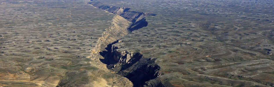
Why Do Some US Earthquakes Occur in Unexpected Places?
Three seconds after 1:51 p.m., August 23, 2011, a 5.8 magnitude earthquake rattled Virginia.1 With an epicenter 3.7 miles under the ground, located some 41 miles northwest of Richmond, the ground shaking was felt as far away as New York City and even in Toronto, Canada.
In Washington, DC, only 83 miles from the epicenter, visitors inside the observation deck atop the Washington Monument were thrown about by the force of the shaking; falling mortar and pieces of stone caused minor injuries, though all the people inside exited safely.2 Damage occurred throughout the metropolitan Washington area, but the Washington Monument was among the significantly damaged structures. Cracks, spalls, and displacements of stones and joints throughout the building required a major repair process.
Why an Earthquake in Virginia?
Why would the Southeastern USA experience such a devastating earthquake, a region that sits snugly in the middle of a tectonic plate? The ground shaking usually happens in areas that rest on the edges of tectonic plates, such as in California.
Berk Biryol, a seismologist at the University of North Carolina Chapel Hill, and his colleagues set out to investigate a potential cause.3 They put together 3D images of the uppermost part of the earth’s mantle, which is just below the continental crust and comprises the bottom of the North American tectonic plate. The tectonic plates today move at the pace of growing fingernails, moving atop a layer of warm, pliable rock called the asthenosphere (from the Greek ἀσθενής asthenḗs meaning “weak” + sphere meaning “globe”).
Seismic waves, the vibrations from earthquakes, travel right through the earth.
Seismic waves, the vibrations from earthquakes, travel right through the earth. Recordings of them enable a picture of the inside of the earth to be built, much like the x-raying of our bodies reveals a picture of our skeletons.
The 3D seismic images produced by Biryol and his colleagues revealed that the plate’s thickness in the southeast United States was uneven, with thick regions of old dense rock combined with thinner areas composed of younger rocks that were also less dense.
The researchers were scratching their heads, puzzled over what could have caused that unevenness in the plate’s thickness. They speculated that, over time, as new material was slowly added to the plate (such as sediments deposited on top of it) and parts of the plate were pulled apart, areas within the plate of higher density formed. Gravity tended to pull down those denser areas into the mantle, and at some point chunks must have broken off to sink into the gooey asthenosphere below.
At the same time, they speculated, to fill the void left by the chunks peeling off from the bottom of the plate, the lighter (less dense) material in the asthenosphere moved up to fill in the space. That buoyant material then cooled to become the thinner, younger section of the plate.
Where parts of the plate broke off or peeled, the plate became thinner and thus more prone to slip along fault lines, causing seismic activity and the earthquake in Virginia. Because they believe these processes have always been slow and gradual for hundreds of millions of years, they believe the next similarly big earthquake won’t come anytime soon.
The 1811–1812 New Madrid Earthquakes
However, the 2011 5.8 magnitude Virginia earthquake was minor compared to the intense series of the most powerful earthquakes to hit the contiguous US east of the Rockies in recorded history.
At 2:15 a.m. on December 16, 1811, a magnitude 7.5 earthquake with its epicenter in northeast Arkansas was felt strongly over an area of at least 50,000 square miles and moderately across about one million square miles.4 By comparison, the devastating 1906 San Francisco earthquake was felt moderately over only about 6,200 square miles. Fortunately, in this 1811 earthquake, damage to man-made structures was only slight because of the sparse population in the affected area centered where the states of Missouri, Arkansas, Tennessee, and Kentucky meet along the Mississippi River valley. But the damage could have been worse, considering the area around modern Memphis experienced extremely violent ground shaking.
That was only the beginning. Barely six hours later at 8:15 a.m., December 16, 1811, another earthquake with its epicenter again in northeast Arkansas struck with magnitude 7.4, followed by a magnitude 7 aftershock at midnight, December 17, 2011. Then at 9:00 a.m., January 23, 1812, a magnitude 7.3 earthquake struck with its epicenter this time in the extreme southeast corner of Missouri. The affected area experienced general ground warping, fissuring, severe landslides, and caving of stream banks.
But the worst was yet to come. At 3:45 a.m., February 7, 1812, a magnitude 7.5 earthquake struck. With its epicenter near New Madrid, Missouri, that town was destroyed. In St. Louis, many houses were severely damaged, and their chimneys toppled. Land uplift along a fault line created temporary waterfalls on the Mississippi River at Kentucky Bend, created waves that traveled upstream, and caused formation of Reelfoot Lake by obstructing streams in what is now Lake County, Tennessee. A magnitude 7 aftershock also occurred later that same day at 10:40 p.m.
The underlying cause of these powerful earthquakes is not well understood.
The underlying cause of these powerful earthquakes is not well understood. Like the location of the recent Virginia earthquake, this New Madrid Seismic Zone is situated within the North American plate well away from its boundaries where movements against neighboring plates along fault lines regularly produce earthquakes.
Modern faulting in this area of southeastern Missouri bordering Arkansas, Tennessee, and Kentucky seems to be related to an ancient buried geologic feature under the Mississippi River alluvial plain, which has been called the Reelfoot Rift. It is postulated that the New Madrid Seismic Zone is made up of reactivated faults that originally formed when what is now North America began to split apart during the breakup of the supercontinent Rodinia. That was supposedly about 750 million years ago in conventional evolutionary thinking. But in the biblical framework of earth history, that supercontinent was formed by God on Day 3 of the Creation Week about 6,000 years ago, and then broke apart at the start of the global Flood cataclysm about 4,300 years ago.5
Evidently, after the initial rifting, the breaking apart stopped. But the scar or zone of weakness remained deep underground within the North American plate. So any strain building up within the plate exploits this zone of weakness where the rocks can move to ease that strain resulting in these earthquakes.
In recent decades minor earthquakes have continued. The US Geological Survey has recorded more than 4,000 earthquakes since 1974 with epicenters in the New Madrid Seismic Zone situated over this ancient Reelfoot Rift. Forecasts estimate a 7–10% chance in the next 50 years of a repeat major earthquake like those that occurred in 1811–1812, which have been re-evaluated as having magnitudes between 7.6 and 8.0. The Federal Emergency Management Agency (FEMA) has warned that such a serious earthquake in the New Madrid Seismic Zone could result in “the highest economic losses due to a natural disaster in the United States,” with “widespread and catastrophic” damage across Alabama, Arkansas, Illinois, Indiana, Kentucky, Mississippi, Missouri, and particularly Tennessee, where a 7.7 magnitude earthquake would cause damage to tens of thousands of structures affecting water distribution, transportation systems, and other vital infrastructure.6
The Role of Deep “Scars” from Ancient Geological Events
Super-computer modeling of the earth’s crust and upper mantle at the University of Toronto, Canada, suggests that ancient geologic events may have left deep “scars” that can come to life to play a role in earthquakes, mountain formation, and other ongoing processes on our planet.7 This changes the widespread view that only interactions at the boundaries between continent-sized tectonic plates could be responsible for such events.
The research team created computer models indicating that former plate boundaries may stay hidden deep beneath the earth’s surface. They claim that these supposedly multi-million-year-old structures, situated at sites away from existing plate boundaries, may trigger changes in the structure and properties at the earth’s surface in the interior regions of continents.
This is a potentially major revision to the fundamental idea of plate tectonics.
“This is a potentially major revision to the fundamental idea of plate tectonics,” said Philip Heron of the research group in the University of Toronto’s Department of Earth Sciences and lead author of their technical paper.8
Heron, Russell Pysklywec, and Randell Stephenson have even proposed a “perennial plate tectonic map” of the earth to help illustrate how ancient processes may have present-day implications. “It’s based on the familiar global tectonic map,” said Pysklywec, who is also chair of the University of Toronto’s Department of Earth Sciences. “What our models redefine and show on the map are dormant, hidden, ancient plate boundaries that could also be enduring or ‘perennial’ sites of past and active plate tectonic activity.”9
To demonstrate the dominating effects that anomalies below the earth’s crust can have on shallow geological features, the researchers used the University of Toronto’s super-computer, Canada’s most powerful computer and one of the most powerful in the world. They used it to make numerical models of the crust and upper mantle into which they could introduce these scar-like anomalies.
The team essentially created an evolving “virtual Earth” to explore how such geodynamic models develop under different conditions. “For these sorts of simulations, you need to go to a pretty high-resolution to understand what’s going on beneath the surface,” said Heron. “We modeled 1,500 kilometers (about 930 miles) across and 600 kilometers (370 miles) deep, but some parts of these structures could be just two or three kilometers (about 1–2 miles) wide. It is important to accurately resolve the smaller-scale stresses and strains.”10
Using these models, the team found that different parts of the mantle below the earth’s crust may still control the folding, breaking, or flowing of the earth’s crust within plates (in the form of mountain-building and seismic activity) when under compression. In this way, the mantle structures dominate over shallower structures in the crust that had previously been seen as the main cause of such deformation within plates.
“The mantle is like the thermal engine of the planet and the crust is an eggshell above,” said Pysklywec. “We’re looking at the enigmatic and largely unexplored realm in the earth where these two regions meet.”11
“Most of the really big plate tectonic activity happens on the plate boundaries, like when India rammed into Asia to create the Himalayas or how the Atlantic opened to split North America from Europe,” said Heron. “But there are lots of things we couldn’t explain, like seismic activity and mountain-building away from plate boundaries in continent interiors.”12
The research team believes their simulations show that these mantle anomalies are generated through ancient plate tectonic processes, such as the closing of ancient oceans, and can remain hidden at sites away from normal plate boundaries until reactivation generates tectonic folding, breaking, or flowing in plate interiors.
“Future exploration of what lies in the mantle beneath the crust may lead to further such discoveries on how our planet works, generating a greater understanding of how the past may affect our geologic future,” said Heron.13
The Legacies of the Global Flood Cataclysm
If this super-computer modeling by the University of Toronto’s research team is technically robust and represents reality, then what they are actually advocating are the lingering after-effects of the biblical global Flood cataclysm that occurred only about 4,300 years ago. Of course, they do not recognize that. Nonetheless, the past geological events that have left their scars, which now affect continuing plate motions and thus generate earthquakes, occurred during the biblical global Flood cataclysm.
The past geological events that have left their scars, which now affect continuing plate motions and thus generate earthquakes, occurred during the biblical global Flood cataclysm.
As already described above, in the biblical framework of earth history it is likely that a supercontinent was formed by God on Day Three of the Creation Week about 6,000 years ago. We are told in Genesis 1:9–10 that God commanded the waters that globally covered the earth on Days One and Two to be gathered into one place in order to let the dry land appear. And it was so. Thus if the waters were in one place which God called seas, then the dry land was also likely in one place, that is, a supercontinent.14
Then that supercontinent and the pre-Flood ocean floor are believed to have broken apart into tectonic crustal plates at the start of the global Flood cataclysm about 4,300 years ago, when the “fountains of the great deep” were all broken up (Genesis 7:11).15 This set those plates into rapid motion (brisk walking pace) across the earth’s surface. The pre-Flood ocean floor sank (subducted) into the earth’s mantle as new ocean floor was generated from magma upwelling into the rift zones, and continental plates collided to form mountain belts.16
The dynamics of the catastrophic plate tectonics during the Flood thus involved rifting, subduction, and collisions between the crustal plates. These interactions inevitably left lasting scars or zones of weakness deep in the crust and in the mantle beneath. As the Flood ended, the plate motions decelerated rapidly.
So the slow motions (rate of fingernail growth) between the plates we still detect today are the residual effects of the global Flood cataclysm. Any strain that builds up within the plates will result in fault movements within these deep scars which generate devastating earthquakes, as New Madrid, Missouri, residents experienced December 1811 to February 1812 and as Washington, DC, residents experienced on August 23, 2011.
The Lesson?
We are still suffering from the after-effects of God’s global cataclysmic Flood judgment on a wicked mankind and an earth filled with violence. Thus when devastating earthquakes occur today, they are meant to remind us of the consequences of man’s sinful rebellion against our Holy Creator God. This should drive us to cry out to Him in repentance, seeking His grace to save us, just as God saved Noah and his Ark animal cargo when the earth was engulfed in the catastrophic upheaval of the Flood.
Footnotes
- Andrea Mustain, “Earthquake Rocks Virginia, DC, NY and Much of Eastern US,” Live Science, August 23, 2011, http://www.livescience.com/15710-earthquake-hits-virginia-east-coast.html.
- National Park Service, “Washington Monument: History & Culture,” https://www.nps.gov/wamo/learn/historyculture/index.htm.
- Kacey Deamer, “Chunks of Earth’s Mantle Are ‘Peeling Off,’” Live Science, May 10, 2016, http://www.livescience.com/54695-chunks-of-earth-mantle-are-peeling-off.html.
- “1811–12 New Madrid Earthquakes,” Wikipedia, https://en.wikipedia.org/wiki/1811-12_New_Madrid_earthquakes; and Steve A. Austin, Catastrophes in Earth History (El Cajon, CA: Institute for Creation Research, 1984), 161–163 and 237–238.
- Andrew A. Snelling, “Noah’s Lost World,” Answers 9, no. 2 (April 2014): 80–85, https://answersingenesis.org/geology/plate-tectonics/noahs-lost-world/; and Andrew A. Snelling, “A Catastrophic Breakup—A Scientific Look at Catastrophic Plate Tectonics,” Answers 2, no. 2 (April 2007): 44–48, https://answersingenesis.org/geology/plate-tectonics/a-catastrophic-breakup/.
- “1811–12 New Madrid Earthquakes.”
- University of Toronto, “Deep ‘Scars’ from Ancient Geological Events Play Role in Current Earthquakes,” Science Daily, June 10, 2016, https://www.sciencedaily.com/releases/2016/06/160610094437.htm.
- Philip J. Heron, Russell N. Pysklywec, and Randell Stephenson, “Lasting Mantle Scars Lead to Perennial Plate Tectonics,” Nature Communications 7, June 10, 2016: doi:10.1038/ncomms11834.
- University of Toronto, “Deep ‘Scars’ from Ancient Geological Events Play Role in Current Earthquakes.”
- Ibid.
- Ibid.
- Ibid.
- Ibid.
- Snelling, “Noah’s Lost World.”
- Snelling, “A Catastrophic Breakup—A Scientific Look at Catastrophic Plate Tectonics.”
- Andrew A. Snelling, “Plate Tectonics—The Reality Behind a Theory,” Answers 11, no. 1 (January 2016): 52–55, https://answersingenesis.org/geology/plate-tectonics/plate-tectonics-reality-behind-theory/; and Andrew A. Snelling, “The Flood—A Global Tectonic Catastrophe,” Earth’s Catastrophic Flood: Geology, Creation and the Flood (El Cajon, CA: Institute for Creation Research, 2009), 683–689; and Andrew A. Snelling, “Catastrophic Plate tectonics—The Driving Force of the Flood,” Earth’s Catastrophic Flood: Geology, Creation and the Flood (El Cajon, CA: Institute for Creation Research, 2009), 691–706.
Support the creation/gospel message by donating or getting involved!

Answers in Genesis is an apologetics ministry, dedicated to helping Christians defend their faith and proclaim the good news of Jesus Christ.
- Customer Service 800.778.3390
- © 2024 Answers in Genesis