

Illustration by Joe Cavazos
A Deeper Understanding of the Flood—A Complex Geologic Puzzle
The details of the Flood have profound implications for explaining the geology of the earth today. In the 1960s secular geologists discovered a broad pattern in the rock layers that has puzzled them, but the Bible holds the key.
The bathtub Arks and “forty days of rain” we often hear in Sunday school don’t begin to do the Flood justice. The forces that God unleashed tore apart the entire world, destroying all land-dwelling animals in a complex sequence of events that is hard to imagine.
No other catastrophe has ravaged the earth on this scale, so we have little to compare it to. For that reason it’s all the more important to interpret the Bible’s chronology of events correctly if we hope to understand the complex geology that the Flood produced and we observe today.
Some people interpret Genesis to mean that heavy rains caused the sea level to rise steadily for 150 days, and then drop steadily until the end of the Flood, on day 371. But a closer look at the Bible indicates that another sequence is more likely—the waters peaked on day 40, and then rose and fell until the end.
This sequence of events could help solve one of the greatest mysteries in geology, megasequences (described below), which has long puzzled geologists, both evolutionists and creationists.
Possibility of Rising and Falling Waters
The Bible says that God planned for it to rain “forty days” (Genesis 7:4), and then the Bible says it happened just as He said—for “forty days” (Genesis 7:12). This plain reading, held by many Hebrew scholars for centuries and strongly supported by recent scholarship, indicates that the sea level likely reached its peak on day 40 (Genesis 7:17–20). But what happened next?
One of two things is possible: the sea level fluctuated until day 150 and then steadily decreased to day 371, or it began decreasing right after day 40. More study is needed. But either way, the violent currents had many months to sweep around the globe in a complex, shifting pattern of alternating high-energy and lower-energy waves, depositing the complex sequence of layers we see today.
A Solution to Megasequences
The intense, worldwide exploration for oil has produced an incredibly detailed picture of the interior of the crust, the earth’s outer skin. The large-scale pattern that oil companies have found continues to mystify geologists.
In 1963 a landmark paper proposed the fossil-bearing, sedimentary rock layers across North America had been deposited in at least four large “packages” of layers called megasequences.1 During the early 1980s the American Association of Petroleum Geologists (AAPG) conducted a massive project to line up and match the rock layers in all the local sequences across North America, determined from drill-holes and the rock layers that are exposed on the surface.2 The outcome was an overwhelming confirmation that these strange megasequences exist.
For geologists who believe in local floods, it was strange to find large-scale deposits, thousands of feet thick, covering the entire continent. Consider closely what they found.
A megasequence is a package of sediment layers of a continental scale bounded above and below by flat, eroded surfaces, called unconformities. Between these eroded surfaces are layers of sediments, which show a distinct pattern from bottom to top. Generally, the sediment grains become smaller and smaller the higher you go. At the bottom are large boulders and rocks (conglomerates), then sands, mud, and finally limestone. This is especially evident on the AAPG charts.
This decreasing size suggests that the energy of the water was very intense at the beginning and then decreased throughout the rest of the process. At the beginning, when the rushing water had the highest energy, it eroded across the surfaces of the continents to produce the unconformity. As the energy decreased, large pieces of rocks (conglomerates) began dropping out, but the rapid currents still carried the finer sediments. Next the sand dropped out, then the mud, and finally limestone (which is formed in relatively lower-energy solutions, when molecular-size minerals form crystals).
This pattern creates a quandary for secular geologists. A megasequence is usually interpreted as the sediments left behind when the ocean rose and advanced across the continent, depositing a large package of sediment layers before retreating. But how could the ocean cover entire continents by the conventional slow-and-gradual (uniformitarian) model?
The biblically derived Flood model provides the answer. The pattern suggests the water levels were high from early in the Flood, with vertical fluctuations in between. Most of the erosion would have occurred between megasequences, as the high-energy ocean waters advanced over the continents. But the dropping waters represented a time of relatively lower energy, when rocks and grains began dropping out of the currents (Figure 1).3
What Is a Megasequence?
The quest for oil has produced an incredibly detailed picture of the earth’s outer rock layers. In the 1960s geologists discovered a large-scale pattern in North America, called megasequences, that still mystifies them. Nobody expected to find large-scale deposits, thousands of feet thick, covering the entire continent.
A megasequence is a package of sediment layers bounded above and below by flat, eroded surfaces, called unconformities. The layers of sediments show a distinct pattern with grains becoming smaller and smaller the higher up you go.
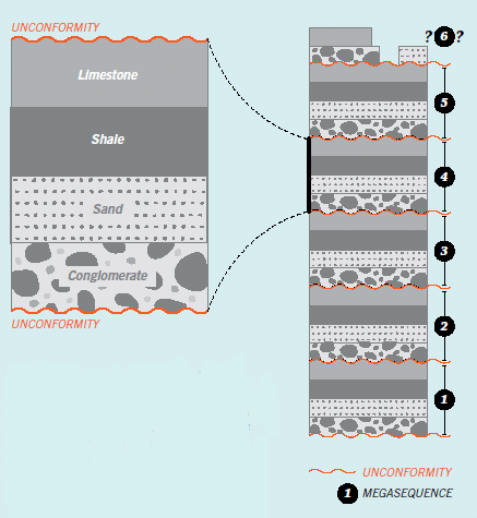
Figure 1 In a megasequence the grains decrease in size from boulders at the bottom (conglomerates) to tiny grains of lime at the top. This “fining upward” suggests the ocean currents were very intense at first, and then the waters slowed down. The heaviest material dropped out first, followed by lighter materials (sand and then clay), until only the finest grains (lime) were left. But why did this happen several times?
Did the Flood Cause Megasequences?
Geologists have discovered that powerful forces eroded the entire North American continent, and then deposited the debris over the whole continent. This was repeated several times. How is this possible? The obvious answer is the Flood.
Secular geologists have found a clear pattern in the rock layers that point to the Flood. At the bottom is bedrock (usually labeled “Precambrian”), which was eroded and planed off by the Flood. As ocean waters tore across the continents, they laid down several megasequences (Cambrian through the Upper Cretaceous).
The rise and fall of the ocean level during the Flood may help explain these megasequences.
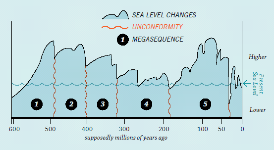
Figure 2 Several Megasequences. Megasequences are separated by flat, eroded surfaces, called unconformities. To erode a flat surface across the entire continent means the ocean water was incredibly energetic. As the waters slowed down, they deposited another megasequence on top of the unconformity. This process was repeated.
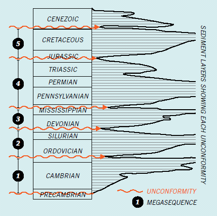
Figure 3 Rise and Fall of Ocean Levels? Secular geologists have discovered evidence that the ocean level rose and fell between each unconformity. While they assume this occurred over millions of years, creationists believe it happened during the Flood.
The preserved rock record across North America readily reflects at least four of these megasequences, separated by unconformities (Figure 2).4 Within these megasequences we usually find mass burials of creatures that were caught up in the Flood waters.
Megasequences show clear evidence of the flood waters rising to advance across the continent, sweeping away creatures, and burying them.
These megasequences show clear evidence of the Flood waters rising to advance across the continent, sweeping away creatures, and burying them in sediment layers. This process explains why we now see ocean creatures buried in layers across the continent.5 It is even possible to trace individual layers of rapidly deposited marine fossils right across the continent.
We see from these megasequences that the Flood was anything but a tranquil affair. Raging waters swept across the continent and back again as water levels apparently fluctuated up and down many times (Figure 3). But what geologic mechanism could have caused such fluctuations, and when did they occur within the sequence of events in the Genesis account?
Catastrophic Plate Tectonics
That’s where another clue comes in. In 1859 a Christian geologist noticed the coastlines of the continents on either side of the Atlantic Ocean fit like a jigsaw puzzle.6 He thus proposed that a pre-Flood supercontinent had been broken up and the continental fragments then sprinted apart during the Flood to open up the Atlantic Ocean.
Thus was born the catastrophic plate tectonics model, which gives a physical mechanism for the Flood.7 If all the waters of the pre-Flood world had been gathered together by God into one place (Genesis 1:9), it is reasonable to conclude there was a pre-Flood supercontinent. Much geologic data is consistent with that.8
So when the fountains of the great deep were broken up at the initiation of the Flood (Genesis 7:11), that event could have ripped apart the pre-Flood supercontinent. Then the continental fragments dashed across the earth’s surface.
This geologic disaster would also explain the rise of the ocean waters. When the supercontinent ripped apart, humungous volumes of lavas also spewed out from inside the earth.9 Since hot rocks expand, the new volcanic rocks on the ocean floor rose, raising sea level and pushing the ocean waters over the continents.
Today we can visit places like the coastlines of eastern Canada and the British Isles to see where some of the fossil-bearing sediment layers and volcanic rocks match between continents.10 This is powerful evidence that the continents were originally joined but are now thousands of miles apart.
These earth movements and the earthquakes they generated would have produced many cataclysmic tsunamis that swept over the continents, contributing to relatively minor water-level fluctuations within the larger-scale surges that deposited the megasequences.
When Did It End?
Plate tectonics not only helps us explain when the megasequences were deposited, it also helps us understand when they ended.
As the water was depositing these major sediment packages during the Flood, the continental fragments occasionally slammed into one another. The collisions produced crumpled mountain belts, such as the Appalachians and the European Alps. Since these mountains already contained fossil-bearing layers before they were crumpled, the mountains must have formed after some megasequences were deposited.
The Bible gives us a clue when the final mountain-building stage had begun. The Genesis account records that the Ark landed on the “mountains of Ararat” on day 150 of the Flood event. This ties the biblical account to known geology. Geologists have learned that these fossil-bearing mountains formed when the African and Arabian Plates collided with the Eurasian Plate. So by that time the Flood’s megasequences were already deposited, and most continental movement had ceased.
God’s Word Is Our Ultimate Authority
As we study God’s Word, we continue to learn new ways that the Flood sheds light on the mysteries within the geologic record, such as the huge packages of sediment layers (megasequences) that the Flood waters deposited as they progressively buried creatures. We will never be able to put all these puzzle pieces together without the help of God’s Word. It is our ultimate authority and the first place we must go.
This record of the truth was given to us by God, the eternal eyewitness. Every word is true. So the details meticulously recorded in ancient Hebrew must be our first instructors on every topic. From careful study of the Bible’s words, modern scientists can glean key time markers and accurate descriptions of physical phenomena, which are crucial to refining their understanding of new discoveries in geology.
As always, we can be confident the evidence in God’s world will be consistent with God’s Word. And it glorifies our Creator and Savior when we build our worldview upon that foundation.
holds a PhD in geology from the University of Sydney and has worked
as a consultant research geologist in both Australia and America. Author of numerous
scientific articles, Dr. Snelling is now director of research at Answers in Genesis–USA.
Answers Magazine
April – June 2014

A closer look at the Genesis Flood account reveals a beautifully written, unified narrative that points to one inspired author. The passage masterfully highlights one central message: “God remembered Noah.” Along with in-depth articles on the Flood, this issue shows biblical and historical evidences of Christ’s Resurrection, new discoveries about the miracle of a butterfly’s metamorphosis and much more!
Browse Issue SubscribeFootnotes
- L. Sloss, “Sequences in the Cratonic Interior of North America,” Geological Society of America Bulletin 74 (1963): 93–114.
- F. A. Lindberg, ed., Correlation of Stratigraphic Units of North America (COSUNA): Correlation Chart Series (Tulsa, Oklahoma: American Association of Petroleum Geologists, 1986).
- J. P. Davidson, W. E. Reed, and P. M. Davis, Exploring Earth: An Introduction to Physical Geology (Upper Saddle River, New Jersey: Prentice-Hall, 1997).
- L. R. Brand, Faith, Reason and Earth History (Berrien Springs, Michigan: Andrews University Press, 1997).
- A. A. Snelling, “High and Dry Sea Creatures,” Answers 3.1 (January–March 2008): 92–95; A. A. Snelling, “Transcontinental Rock Layers,” Answers 3.3 (July–September 2008): 80–83.
- A. Snider-Pellegrini, La Création et ses Mystères dévoilés (Paris, France: A. Frank et E. Dentu, 1859).
- S. A. Austin, J. R. Baumgardner, D. R. Humphreys, A. A. Snelling, L. Vardiman, and K. P. Wise, “Catastrophic Plate Tectonics: A Global Flood Model of Earth History,” in Proceedings of the Third International Conference on Creationism, R. E. Walsh, ed., (Pittsburgh, Pennsylvania: Creation Science Fellowship, 1994), pp. 609–621.
- A. A. Snelling, “Geophysical Issues: Understanding the Origin of the Continents, Their Rock Layers and Mountains,” in Grappling with the Chronology of the Genesis Flood, S. W. Boyd and A. A. Snelling, eds. (Green Forest, Arkansas: Master Books, 2014), pp. 111–144. The pre-Flood supercontinent was likely similar to what evolutionary geologists call Rodinia. A fuller discussion of the evidence for this pre-Flood supercontinent is presented in “Noah's Lost World,” page 80.
- P. Garner, “Continental Flood Basalts Indicate a Pre-Mesozoic Flood/Post-Flood Boundary,” Creation Ex Nihilo Technical Journal 10.1 (1996):114–127.
- A. A. Snelling, “The Geology of Israel within the Biblical Creation-Flood Framework of Earth History: II. The Flood Rocks,” Answers Research Journal 3 (2010): 267–309; A. A. Snelling, 2013, Ibid.

Support the creation/gospel message by donating or getting involved!

Answers in Genesis is an apologetics ministry, dedicated to helping Christians defend their faith and proclaim the good news of Jesus Christ.
- Customer Service 800.778.3390
- © 2024 Answers in Genesis