
Chapter 15
Layers of Sedimentary Rock Deposited by Global Flood
Could the Flood Cataclysm Deposit Uniform Sedimentary Rock Layers?
This is definitely a legitimate question to ask concerning the nature of the evidence one would expect to be left behind by the Flood cataclysm. Because the waters of local floods today are often full of sediments and are fast-moving, it is commonly thought that neat, uniform sediment layers are not deposited under such conditions. So this question needs close examination, starting by looking at what the evidence is that we see in the rock record.
Do We Find Neat Uniform Layers of Sedimentary Rock in the Geologic Record?
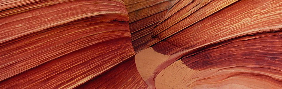
Whether looking into the Grand Canyon from one of the rim overlooks or traversing through the Grand Canyon on foot or by raft, the answer to this question is obviously yes. The fossil-bearing sedimentary layers deposited by the Flood can be seen exposed in the walls, stacked on top of one another like a huge pile of pancakes. And the view is much the same no matter where one views the Grand Canyon. So at the regional scale in the Grand Canyon area it is clearly evident that the sedimentary rock layers deposited there during the Flood cataclysm are neat and uniform.
Similar observations can be made in many other places across the earth’s surface. This pattern is often seen in road cuts and in mountainous areas where erosion has exposed the constituent rock layer sequences. So it is hardly necessary to defend the assertion that the fossil-bearing sedimentary layers that were deposited during the Flood cataclysm are generally neat and uniform and stacked in a sequence that is exposed to view in many places across the earth’s continents.
The assertion that these fossil-bearing sedimentary layers were deposited during the Flood cataclysm is easy to defend.1 The obvious observation to make is that many of these fossil-bearing sedimentary layers contain fossils of creatures that today live on the shallow ocean floors fringing the continents, and not on the continents where countless billions of them are buried in these sedimentary layers. Indeed, sedimentary rock layers containing the same fossils are not found on the ocean floors today, nor are they found in comparable dimensions on the continental shelves fringing the continents. But the vast marine-fossil-bearing sedimentary layers we find spread right across the continents today are thus consistent with the ocean waters having flooded over the continents on a global scale, tearing marine creatures from their shallow ocean floor habitats and picking up sediments, then burying those creatures in those sediments up and across the continents in vast sedimentary layers. This is consistent with the biblical description of the Flood.
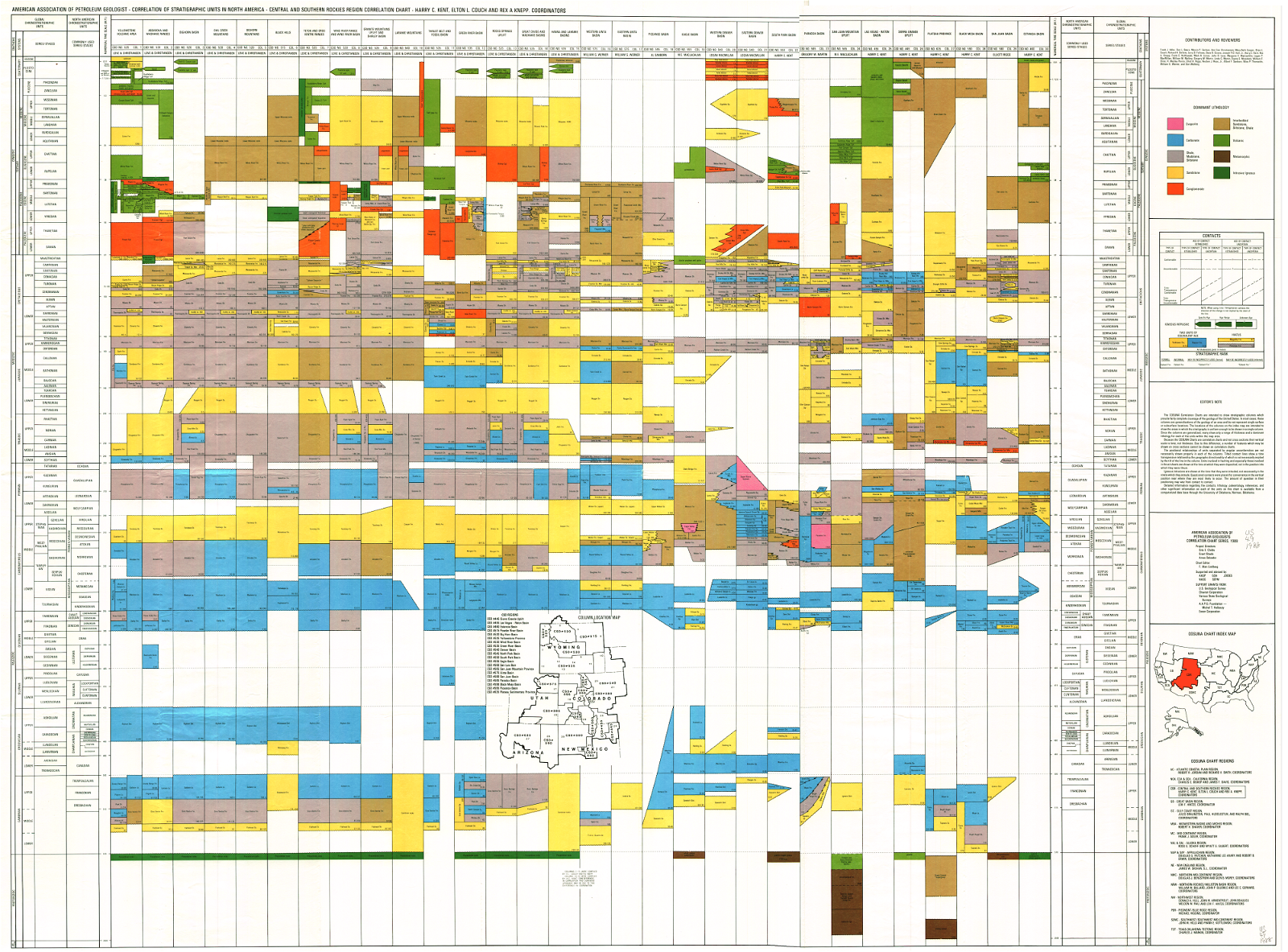
Figure 1. An example of one of the charts produced during the AAPG project showing the local strata columns in the central and southern Rockies region of the USA.
Many geologists are already aware that there are six thick sequences of fossil-bearing sedimentary strata, known as megasequences, which can be traced right across the North American continent. This was documented five decades ago in 19632 and subsequently verified by numerous observations so that it is now well recognized. In the early 1980s, the American Association of Petroleum Geologists (AAPG) conducted a project in which all the local geologic strata “columns” derived from the mapping of outcrops in local areas, supplemented by drill-hole data, were put on charts to show the sequences of fossil-bearing sedimentary rock layers right across the North American continent (figure 1).3
The rationale used to identify these megasequences was based on mapping the preserved rock record across the North American continent. These thick sequences or packages of fossil-bearing sedimentary rock layers were easily identified because they were bounded by erosion surfaces (called unconformities) due to the actions of the ocean waters as they advanced over the continent depositing the sedimentary rock layers before retreating again (figure 2).4 These unconformities therefore coincide with rising and falling water levels as ocean waters oscillated across the continent and back again after depositing their sediment loads, often also coinciding with the mass burial of creatures in what evolutionary geologists have called mass extinctions. Significantly, some of the fossil-bearing sedimentary layers in these megasequences can also be traced beyond North America to other continents.5
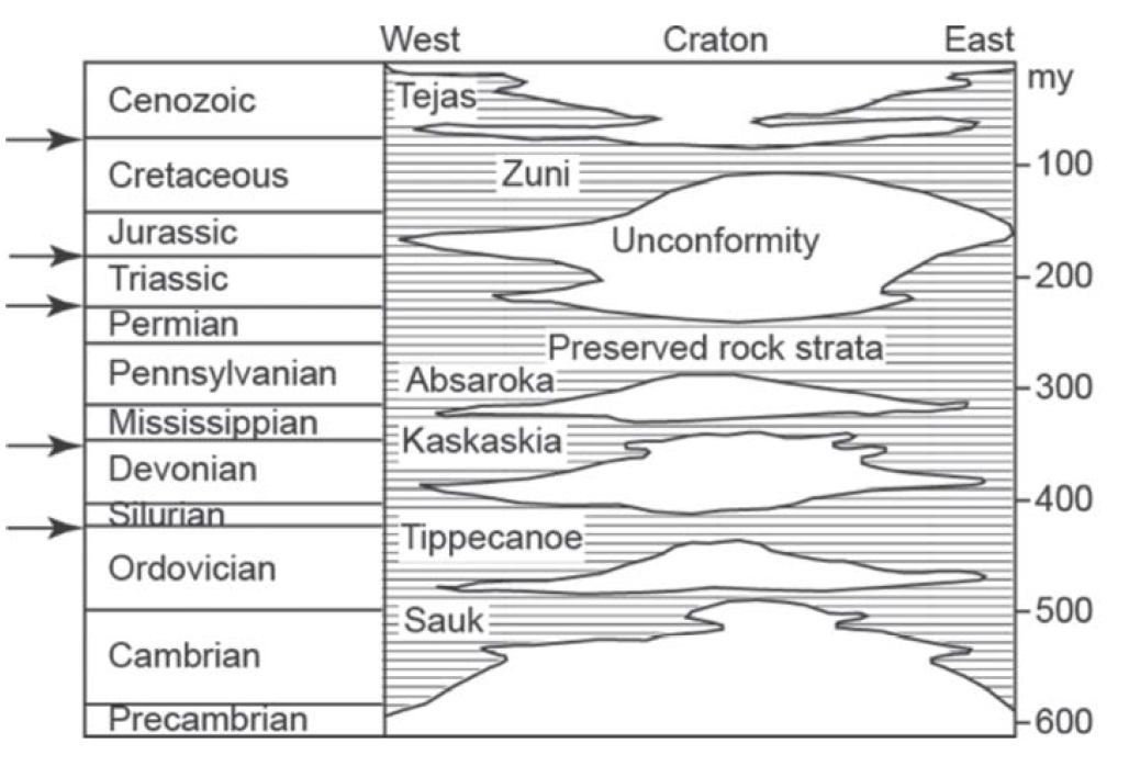
Figure 2. The preserved rock record, consisting of named megasequences, between major unconformities and mass extinctions (arrowed) across the north American continent.
Within each megasequence are various named strata units. For example, the first (lowermost) of these megasequences, called the Sauk Megasequence, in the Grand Canyon area consists of the Tapeats Sandstone, the Bright Angel Shale, and the Muav Limestone. Thorough geologic mapping was initially only done locally, so the rock units identified and mapped were given names locally. Therefore, even if a rock unit stretched into adjoining local areas and beyond, it often had different names in adjoining local areas. Thus, in the 1980s, when the American Association for Petroleum Geologists (AAPG) tabulated all the local strata columns across the continent, it became possible to see how some specific rock units, which had been given different names in different local areas, actually were the same unit, which could be traced vast distances across the continent. The Tapeats Sandstone in the Grand Canyon area is one of those units, and it can be traced all across Arizona northward to the Canadian border and beyond, northeastward right across the USA as far as Maine (figure 3).6 The same sandstone unit in exactly the same geologic strata position is also found in southern Israel, from where it can be traced across to Jordan and into Egypt, and then right across north Africa.7 Thus the Tapeats Sandstone represents one unit within one megasequence that is easily identified over vast continental scale areas due to its uniform makeup.
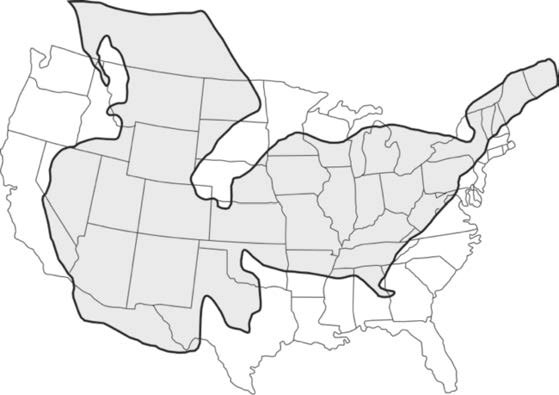
Figure 3. The distribution of the Tapeats Sandstone and its equivalents across North America, constructed from the local geologic columns compiled in the COSUNA charts produced by the AAPG.
However, while some units within megasequences traverse continents, many others are only recognizable and able to be traced over regions, though still vast in extent compared to one’s local area. In the Grand Canyon area, for example, the Coconino Sandstone, within the fourth of the megasequences, known as the Absaroka Megasequence, can be traced from northern and central Arizona across New Mexico into Colorado, Kansas, Oklahoma, and Texas over an area approaching 200,000 square miles, though an isolated remanent in southwestern Arizona indicates the unit previously had a wider distribution that has been reduced by erosion (figure 4).
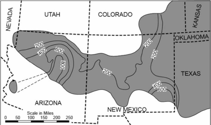
Figure 4. The distribution of the Coconino Sandstone and its equivalents from northern Arizona into adjoining states, showing the variations in its thickness (contour lines in feet) (after Austin8).
Nevertheless, not all the strata units are uniform, the character of the rock units changing due to later variations. For example, the Toroweap Formation is a limestone in the Grand Canyon area, but laterally to the southwest it changes into sandstone, along with local variations that include beds of gypsum to the west.9 Indeed, many strata units change their rock character laterally, reflecting both the type and composition of the sediments within the mixture carried by the ocean waters over the continent to deposit them. Furthermore, not only is the sediment composition related to the source of the sediments, but changes in the sediment composition can occur. As the ocean waters carried sediments up and across the continent, they sometimes eroded underlying sediment layers of different compositions, adding them to their sediment loads before eventually depositing them.
Another aspect of this question is the thickness of the fossil-bearing sedimentary rock layers deposited across the continents. Even on local scales, variations in the thicknesses of strata units can be seen, as well as sometimes even compositional changes. So, for example, even though the Coconino Sandstone averages a thickness of 315 feet in the Grand Canyon area, it changes its thickness through the length of the Grand Canyon, thinning to the west and thickening even up to 1,000 feet toward the southeast (see figure 4). Furthermore, some rock units are made up of beds of alternating compositions, such as within some of the strata units in the Cincinnati area which consist of alternating beds of limestone and shale (figure 5).10 Sometimes these thinner beds thicken and thin even within the outcrop scale of a road cut. So whereas we do find neat, uniform fossil-bearing sedimentary rock layers across the continents as a record of the Flood, the depositional processes produced and left behind local variations, both in thicknesses of the layers and beds within the named strata units, but also variations in compositions, from local to regional scales.
Were the Fast-Moving Flood Waters Also Churning?
During the Flood cataclysm, there were four main causes for generating the surging flows of water currents that picked up and carried sediments onto and across the continents to deposit the fossil-bearing sedimentary rock layers there.
First, there was the normal ebb and flow of the rising and falling tidal oscillations. The effect of these approximately twice-daily tidal surges would have increased as the Flood waters became global. It has been shown that on a global ocean there would have been a resonating effect by which the tidal surges would have progressively built in height and, therefore, in the strength and impact of each surge, due to the close overlapping of the tidal peaks and troughs in the approximate 12–13 hour spacing between successive highs and lows.11
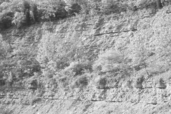
Figure 5. Alternating beds of limestone (hard) and shale (soft) in the Fairview Formation in a road cut in the Cincinnati area of northern Kentucky. (Photograph: Andrew A. Snelling)
Superimposed on those tidal flows and surges, there would have been repeated tsunamis generated by earthquakes caused by repeated catastrophic earth movements. The “fountains of the great deep” were broken up (Genesis 7:11), initiating the catastrophic plate tectonics that drove the Flood event.12 The earth’s crust was broken up around the globe, producing massive earthquakes, followed by the accelerated motion of the crustal fragments (called plates) across the earth’s surface at many-feet-per-second speed. As the Flood event progressed, plates collided with one another, or some plates were pushed under the edges of other plates. All these earth movements would have generated many catastrophic earthquakes that in turn would have repeatedly produced massive tsunamis. As these tsunamis moved, they would have surged toward and onto the continents.
Furthermore, superimposed on the tides and tsunamis would have been the progressive raising of the ocean floor. As the ocean floor plates were pushed apart, molten rock rose from inside the earth to generate new ocean floor rocks. The new warm ocean floor, being less dense, would steadily rise, thus pushing up the sea level. This raising of the sea level would have in turn caused a surge of ocean waters toward the continents to flood them.
The net result would have been huge fluctuations in the water levels combined with catastrophic surges of walls of water moving from open ocean areas toward and onto the continents and across them. Yet another force at work driving these surging water currents would have been super-storms. These would have been generated in the atmosphere as a result of the supersonic steam jets at the crustal fracture zones, catapulting ocean waters aloft before they fell back to the earth’s surface as global torrential rainfall (the “windows or floodgates of heaven” were opened, Genesis 7:11). It is estimated that such super-storms and their winds moving across the surface of the Flood waters would have driven water currents at speeds of 100 miles an hour or more.13
So there is no doubt that there were adequate mechanisms for driving fastmoving, catastrophically powerful water currents and surges from the oceans toward and onto the continents. These were thus capable of carrying the sediments and creatures to be buried in the fossil-bearing sedimentary rock layers deposited across the continents, stacked up in sequence as a result of the fluctuating water levels and the ebb and flow of the water.
Just as is observed today, in the open ocean there are no major effects on the ocean surface from the passage of tsunamis, tidal surges, and fast-moving water currents apart from waves. It is at the base of the water column deep below the surface where the moving and surging water picks up loose sediments from the ocean floor, or scours and erodes sediments from the ocean floor, and then transports them in a slurry of sediment-laden water.
What was happening at the base of the water column of these surging, fastmoving water currents during the Flood would have depended on a number of factors, which in turn would have produced differing results. Though somewhat oversimplified, if the water was flowing over uneven ocean floor topography, then turbulent flow (churning water) could be generated. But if the water was flowing over a flat surface, then the flow would be laminar and sheet-like, and any erosion would result from cavitation, a process in which the fast water flow generates vacuum bubbles that hammer rock surfaces, pulverizing the rock rapidly. If there were loose sediments on the surface being traversed, once the water reached a critical speed it would pick up those loose sediments and carry them. Often, once the process is started, if there is even the slightest of downward slopes on the surfaces being traversed, then gravity takes over to produce debris flows. Many strata units in the rock record bear testimony to having been deposited by gravity-driven underwater debris flows.
The quantity and type of sediments transported would depend on the composition and particle sizes in those loose sediments, so that generally the faster the water flow, the greater the sizes of the particles that could be picked up and transported. Below a critical speed, no sediments would be picked up and carried by the water flows. And that critical speed would likely be lower for turbulent flow and higher for laminar flow, except where gravity is driving the water’s ability to pick up sediments to produce debris flows. At higher speeds and carrying more sediment, the water at the base of the water column would become more erosive. The more sediments the water carried, the more they would add to the water’s abrasive and erosive power. At the highest water speeds though, when the amount of sediment in the water is greater than the amount of water in the slurry mixture, the density of the slurry is so great that even boulders are transported, suspended in the slurry.
Fast-moving waters are certainly capable of depositing sediments, and many strata layers in the rock record of the Flood would have been deposited in that way, as witnessed by the strata layers that were deposited right across continents. Additionally, once the water started to slow down in its passage over the continents, the water would start to drop the rest of its sediment load and deposit it in more sediment layers, also burying the creatures that had been carried by the water. An example is the postulated progressive simultaneous deposition of the Tapeats Sandstone, Bright Angel Shale, and Muav Limestone across Nevada, Arizona, and New Mexico as the Flood waters advanced, the bottom current speed decreasing in the returning underflow so sediments of decreasing grain sizes were progressively deposited.14 As the water slowed it would also be less likely to erode previously deposited sediment layers, especially where the surface of those previously deposited sediment layers had started to cohere, and cementation had begun to bind the sediment particles (the first stage of the hardening process).
The net result would be that the Flood waters at the base of the flow would tend to erode in source areas as the current flow increased, and then started switching to depositional mode as the water currents flowed over the continents and started to deposit their loads. Thus, when the water currents subsequently slowed as they continued further sediment deposition, they would not be eroding at the same time. The outcome would be to deposit uniform sediment layers during their passage across the continents as they progressively spread out and deposited their sediment loads. Of course, there could be lateral variations in sediment types. Sometimes as the waters slowed, the heavier particles would settle out first. Then at slower speeds finer particles would be deposited, so that the sediment particle sizes could change laterally as the one rock unit was deposited across the continent. In some strata layers the grading of the sediment particle sizes is the inverse. But many layers do not exhibit any graded bedding. Instead, the changes between water flow surges meant changes in sediment loads, with sediments of different compositions and types, each consisting of uniform similar particle sizes being deposited, such as lime mud versus quartz sand, as in the example of the Toroweap Formation in the Grand Canyon area being deposited on top of the Coconino Sandstone, as has already been mentioned.
Natural and Experimental Examples
In 1960, Hurricane Donna created surging ocean waves that flooded inland up to five miles along the coast of southern Florida for six hours.15 As a result, the hurricane deposited a neat, uniform six-inch-thick mud layer, with numerous thin laminae within it, across the area traversed by the flood waters. In June 1965, a storm in Colorado produced flooding of Bijou Creek, which resulted in the deposition from the fast-moving waters of new sediment layers containing fine laminations.16 Then on June 12, 1980, an eruption of Mount St. Helens produced a hurricane-velocity, surging-flow of volcanic ash, which accumulated in less than five hours as a neat, uniform 25-foot-thick layer of laminated volcanic ash, including uniform neat, alternating laminae of coarse and fine sediment grains (figure 6).17
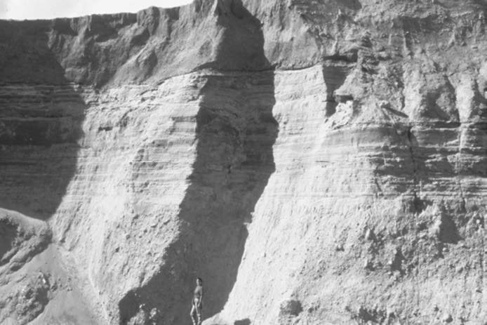
Figure 6. The 25-foot-thick deposit is exposed in the middle of the cliff. The fine layering within this deposit was produced within hours at Mount St. Helens on June 12, 1980, by hurricane-velocity surging flows from the crater of the volcano. (Photograph: Steven A. Austin)
In a detailed study of a seven-foot-thick bed within the Redwall Limestone in the Grand Canyon area, Austin18 has convincingly argued that the evidence is consistent with the bed’s deposition by a gravity-driven debris flow. In the middle section of this bed, which has been traced over more than 11,600 square miles, are billions of straight-shelled nautiloid fossils of various lengths. Though mostly buried and fossilized horizontally, some are found at various angles, and some are even vertical. These and the ubiquitous vertical fluid evulsion structures are consistent with rapid burial in a debris flow that turbulently tossed some of the nautiloids around during this mass kill event. Yet the bed overall is neat and uniform over this large area.
The three observed examples described above demonstrate that local-regional natural catastrophes do deposit neat, uniform sedimentary rock layers, even though in most instances the flow of water and air respectively was rapid and sometimes turbulent (churning). It should also be noticed that in two of the three examples the surging, fast-moving sediment-laden flows did not erode into the surfaces they flowed over, even though those surfaces consisted of loose materials (soils and sands, and previously deposited volcanic ash, respectively). Instead, the flows left smooth, neat, uniform boundaries at the bases of the neat, uniform sediment layers they deposited. These sediment layers resulting from these local-regional natural catastrophes closely mirror at a smaller scale the neat, uniform sedimentary layers left behind by the Flood waters, stacked up neatly on top of one another with smooth, uniform boundaries between them.
Not only do we have numerous modern examples where local-regional natural catastrophic events have resulted in the rapid accumulation of neat uniform sedimentary layers, but we have numerous laboratory experiments that have allowed researchers to document the same processes. For example, using a circular flume, it was demonstrated that high-velocity water currents sort and deposit sediment grains by weight, density, and shape, and that as the fast-moving current loses its velocity, the segregation of grains produces a succession of thin, parallel laminae in the resultant neat uniform sediment layer.19 Other linear flume experiments with water swiftly carrying sand grains have demonstrated how a neat uniform sand layer is progressively deposited as the sand-carrying water current advances.20 These examples demonstrate that water moving at upper (high) flow regime speeds produces planar beds rapidly. Indeed, the results of such flume experiments correlate closely with the observed natural sedimentation processes from swift-flowing water in tidal channels, floods, and other catastrophic events, and also accurately replicate at a smaller scale the features seen in the neat uniform sedimentary rock layers preserved in the continental geologic record.
The difference between the flume experiments and the observed local-regional natural catastrophes on the one hand, and between the observed local-regional natural catastrophes and the global Flood cataclysm on the other, is in both instances the scale of the sedimentation. However, it is a progressive increase in scale from the flume experiments to the observed local-regional natural catastrophes, and then to the scale of the global cataclysmic Flood. Nevertheless, it has been demonstrated that both the flume experiments and the local-regional natural catastrophes produce neat, uniform sediment layers by deposition from the laminar (sheet) flow of fast-moving waters, rather than from turbulent (churning) flow. Thus, because the continental-scale sedimentary rock layers deposited during the Flood cataclysm are neatly uniform across the continents, it is evident that even under global cataclysmic Flood conditions it was the laminar flow of fast-moving waters, and not turbulent or churning waters, that were responsible for the deposition of these neat, uniform sedimentary rock layers.
Conclusion
In answer to the question that was posed, namely, how could neat uniform sedimentary rock layers be deposited during the Flood cataclysm with all the fast-moving waters, we have seen that the observed sedimentation processes in both flume experiments and larger scale (local-regional) natural catastrophes result in neat, uniform sediment layers being deposited from fast laminar (sheet)-flowing waters. Thus it has been argued that the observed neat, uniform sedimentary rock layers found deposited across the continents as a result of the global Flood cataclysm can be envisaged to have also been the result of the same sedimentation processes from similarly fast laminar-flowing waters. In other words, we can confidently extrapolate the orders of magnitude to the enormous scale of the global Flood cataclysm. Though the flume experiments have been conducted at various small scales, the orders of magnitude extrapolation to the observed natural catastrophes over large regions still results in the same observed pattern of uniform sediment layers deposited neatly in succession by fast-moving waters. This makes us confident that at the global scale of the Flood cataclysm the same sedimentation processes would have also been responsible for the neat, uniform sedimentary rock layers we observe to have been stacked on top of one another and preserved in the continental geologic record, even though the Flood waters were often fast-moving.
The New Answers Book 4

Building on the previous New Answers Books, learn more about the Gospel and a young earth, death of plants and leaves, dragons, religious wars, cavemen, science, living fossils, and more.
Read Online Buy Book
Master Books has graciously granted AiG permission to publish selected chapters of this book online. To purchase a copy please visit our online store.
Footnotes
- Andrew Snelling, “What Are Some of the Best Flood Evidences?” in Ken Ham, ed., The New Answers Book 3 (Green Forest, AR: Master Books, 2010), p. 283–298.
- Laurence L. Sloss, “Sequences in the Cratonic Interior of North America,” Geological Society of America Bulletin 74, no. 2 (1963): p. 93–114.
- F.A. Lindberg, Correlation of Stratigraphic Units of North America (COSUNA): Correlation Charts Series (Tulsa, OK: American Association of Petroleum Geologists, 1986).
- Leonard R. Brand, Faith, Reason, and Earth History (Berrien Springs, MI: Andrews University Press, 1997).
- Andrew Snelling, “Transcontinental Rock Layers,” Answers (July–September 2008): p. 80–83.
- Andrew Snelling, Earth’s Catastrophic Past: Geology Creation and the Flood (Dallas, TX: Institute for Creation Research, 2009), p. 1082, figure 45.
- Andrew Snelling, “The Geology of Israel within the Biblical Creation-Flood Framework of Earth History: 2. The Flood Rocks,” Answers Research Journal 3 (2010): p. 267–309; available online at http://www.answersingenesis.org/articles/arj/v3/n1/geology-of-israel-2.
- Steven A. Austin, Grand Canyon: Monument to Catastrophe (Santee, CA: Institute for Creation Research, 1994), p. 36, figure 3.13.
- Christine E. Turner, “Toroweap Formation,” in Stanley S. Beus and Michael Morales, eds., Grand Canyon Geology, 2nd ed. (New York, NY: Oxford University Press, 2003), p. 180–195.
- Andrew Snelling, “Cincinnati — Built on a Fossil Graveyard,” Answers (July–September 2011): p. 50–53.
- M.E. Clark, and H.D. Voss, “Resonance and Sedimentary Layering in the Context of a Global Flood,” in Proceedings of the Second International Conference on Creationism, vol. 2, Robert E. Walsh and Christopher L. Brooks, eds. (Pittsburgh, PA: Creation Science Fellowship, 1990), p. 53–63.
- Steven A. Austin, John R. Baumgardner, D. Russell Humphreys, Andrew Snelling, Larry Vardiman, and Kurt P. Wise, “Catastrophic Plate Tectonics: A Global Flood Model of Earth History,” in Proceedings of the Third International Conference on Creationism, Robert E. Walsh, ed. (Pittsburgh, PA: Creation Science Fellowship, 1994), p. 609–621; Andrew Snelling, “A Catastrophic Breakup: A Scientific Look at Catastrophic Plate Tectonics,” Answers (April–June 2007): p. 44–48.
- John R. Baumgardner, and Daniel W. Barnette, “Patterns of Ocean Circulation Over the Continents during Noah’s Flood,” in Third International Conference on Creationism, p. 77–86; Larry Vardiman, “Numerical Simulation of Precipitation Induced by Hot Mid- Ocean Ridges,” in Proceedings of the Fourth International Conference on Creationism, Robert E. Walsh, ed. (Pittsburgh, PA: Creation Science Fellowship, 1998), p. 595–606.
- Steven A. Austin, Grand Canyon: Monument to Catastrophe (Santee, CA: Institute for Creation Research, 1994), p. 69, figure 4.12.
- M.N. Ball, B.A. Shinn, and K.W. Stockman, “The Geological Effects of Hurricane Donna in South Florida,” Journal of Geology 75 (1967): p. 583–597.
- E.D. McKee, E.J. Crosby, and H.L. Berryhill Jr., “Flood Deposits, Bijou Creek, Colorado, June 1965,” Journal of Sedimentary Petrology 37, no. 3 (1967): p. 829–851.
- Steven A. Austin, “Mount St. Helens and Catastrophism,” in Proceedings of the First International Conference on Creationism, vol. 1 (Pittsburgh, PA: Creation Science Fellowship, 1986), p. 3–9.
- Steven A. Austin, “Nautiloid Mass Kill and Burial Event, Redwall Limestone (Lower Mississippian), Grand Canyon Region, Arizona and Nevada,” in Proceedings of the Fifth International Conference on Creationism, Robert L. Ivey, Jr., ed. (Pittsburgh, PA: Creation Science Fellowship, 2003), p. 55–99.
- P.V.H. Kuenen, “Experimental Turbidite Lamination in a Circular Flume,” Journal of Geology 74, no. 5 (1966): p. 523–545.
- Pierre Y. Julien, Yongqiang Lan, and Guy Berthault, “Experiments on Stratification of Heterogeneous Sand Mixtures,” Creation Ex Nihilo Technical Journal 8, no. 1 (1994): p. 37–50.

Support the creation/gospel message by donating or getting involved!

Answers in Genesis is an apologetics ministry, dedicated to helping Christians defend their faith and proclaim the good news of Jesus Christ.
- Customer Service 800.778.3390
- © 2024 Answers in Genesis