
No Slow and Gradual Erosion
Flood Evidence Number Five
by
Dr. Andrew A. Snelling
on
January 1, 2009
; last featured
July 21, 2010
Featured in
Answers Magazine
Today we see the effects of weathering and erosion all around us. But where is the evidence of millions of years between rock layers? There is none.
If the violent global Flood, described in the astonishing narrative of Genesis 7-8, really occurred, what evidence would we expect to find? Wouldn’t we expect to find rock layers all over the earth that are filled with billions of dead animals and plants that were rapidly buried and fossilized in sand, mud, and lime? Yes, and that’s exactly what we find.
This article covers the fifth of six main geologic evidences that testify to the Genesis Flood. We’ll look more closely at a feature that is often overlooked—the boundaries between rock layers. What should they look like, if laid down during a single, global Flood?
Six main geologic evidences for the Genesis Flood
The dominant view today is that slow and gradual (uniformitarian) processes, similar to the processes we observe in the present, explain the thick, fossil-bearing sedimentary rock layers all over the earth. These slow geologic processes would require hundreds of millions of years to deposit all the successive sediment layers. Furthermore, this popular view holds that slow weathering and erosion gradually wore away the earth’s surface to produce its relief features, such as hills and valleys.
This view has a problem, however. If the fossil-bearing layers took hundreds of millions of years to accumulate, then we would expect to find many examples of weathering and erosion after successive layers were deposited. The boundaries between many sedimentary strata should be broken by lots of topographic relief with weathered surfaces. After all, shouldn’t millions of years worth of weathering and erosion follow each deposition?
On the other hand, the cataclysmic global Flood described in Genesis 7–8 would lead us to expect something much different. Most of the fossil-bearing layers would have accumulated in just over one year. Under such catastrophic conditions, even if land surfaces were briefly exposed to erosion, such erosion (called sheet erosion) would have been rapid and widespread, leaving behind flat and smooth surfaces. The erosion would not create the localized topographic relief (hills and valleys) we see forming at today’s snail’s pace. So, if the Genesis Flood caused the fossil-bearing geologic record, then we would only expect evidence of rapid or no erosion at the boundaries between sedimentary strata.
So what evidence do we find? At the boundaries between some sedimentary layers we find evidence of only rapid erosion. In most other cases, the boundaries are flat, featureless, and knife-edge, with absolutely no evidence of any erosion, which is consistent with no long periods of elapsed time, as would be expected during the global, cataclysmic Genesis Flood.
Examples in Grand Canyon
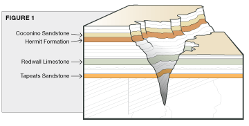
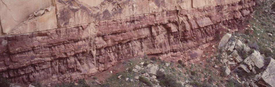
Grand Canyon in the southwestern United States offers numerous examples of strata boundaries that are consistent with deposition during the Genesis Flood.1 However, we will focus here on just four, which are typical of all the others. These boundaries appear at the bases of the Tapeats Sandstone, Redwall Limestone, Hermit Formation, and Coconino Sandstone (Figure 1).
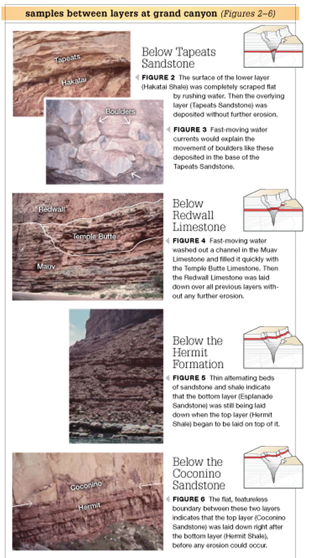
Below Tapeats Sandstone
The strata below the Tapeats Sandstone has been rapidly eroded and then extensively scraped flat (planed off). We know that this erosion occurred on a large scale because we see its effects from one end of the Grand Canyon to the other. This massive erosion affected many different underlying rock layers—granites and metamorphic rocks, and tilted sedimentary strata.
Photos courtesy Dr. Andrew Snelling
There are two evidences that this large-scale erosion was rapid. First, we don’t see any evidence of weathering below the boundary2 (Figure 2). If there were weathering, we would expect to see soils, but we don’t. Second, we find boulders and features known as “storm beds” in the Tapeats Sandstone above the boundary3 (Figure 3). Storm beds are sheets of sand with unique internal features produced only by storms, such as hurricanes. Boulders and storm beds aren’t deposited slowly.
Below Redwall Limestone
Below the base of the Redwall Limestone the underlying Muav Limestone has been rapidly eroded in a few localized places to form channels (Figure 4). These channels were later filled with lime sand to form the Temple Butte Limestone. Apart from these rare exceptions, the boundary between the Muav and Redwall Limestones, as well as the boundary between the Temple Butte and Redwall Limestones, are flat and featureless, hallmarks of continuous deposition.
Indeed, in some locations the boundary between the Muav and Redwall Limestones is impossible to find because the Muav Limestone continued to be deposited after the Redwall Limestone began.4 This feature presents profound problems for uniformitarian geology. The Muav Limestone was supposedly deposited 500–520 million years ago,5 the Temple Butte Limestone was supposedly deposited about 100 million years later (350–400 million years ago),6 and then the Redwall Limestone deposited several million years later (330–340 million years ago).7 Based on the evidence, it is much more logical to believe that these limestones were deposited continuously, without any intervening millions of years.
Below the Hermit Formation
Another boundary at Grand Canyon—the boundary between the Hermit Formation and the Esplanade Sandstone—is often cited as evidence of erosion that occurred over millions of years after sediments had stopped building up.8
There is a problem, however. The evidence indicates that water was still depositing material, even as erosion occurred. In places the Hermit Formation silty shales are intermingled (inter-tongued) with the Esplanade Sandstone (Figures 5), indicating that a continuous flow of water carried both silty mud and quartz sand into place. Thus there were no millions of years between these sedimentary layers.9
Below the Coconino Sandstone
Finally, the boundary between the Coconino Sandstone and the Hermit Formation is flat, featureless, and knife-edge from one end of the Grand Canyon to the other. There is absolutely no evidence of any erosion on the Hermit Formation before the Coconino Sandstone was deposited. That alone is amazing.
Yet somehow a whole extra layer of sediment was dumped on top of the Hermit Formation before the Coconino Sandstone, without time for erosion. In places in central and eastern Arizona, almost 2,000 feet (610 m) of sandstone, shale, and limestone (the Schnebly Hill Formation) sits on top of the Hermit Formation, supposedly representing millions of years of deposition before the Coconino Sandstone was deposited on top of them.10
But where is the evidence of the supposed millions of years of erosion at this boundary in the Grand Canyon area while this deposition was occurring elsewhere (Figure 6)? There is none! So there were no millions of years between the Coconino Sandstone and Hermit Formation, just continuous deposition.
Conclusion
The fossil-bearing portion of the geologic record consists of tens of thousands of feet of sedimentary layers, of which about 4,500 feet (1,372 m) are exposed in the walls of Grand Canyon. If this enormous thickness of sediments was deposited over 500 or more million years, as conventionally believed, then some boundaries between layers should show evidence of millions of years of slow erosion, when deposition was not occurring, just as erosion is occurring on some land surfaces today.
On the other hand, if this enormous thickness of sediments was all deposited in just over a year during the Genesis Flood, then the boundaries between the layers should show evidence of continuous rapid deposition, with only occasional rapid erosion or no erosion at all. And that’s exactly what we find, as illustrated by strata boundaries in the Grand Canyon.
The biblical account of the Flood describes the waters sweeping over the continents to cover the whole earth. The waters flowing right around the earth would have catastrophically eroded sediments from some locations, transported them long distances, and then rapidly deposited them. Because the waters flowed “continually” (the word used in the Scriptures), erosion, transport, and deposition of sediments would have been continually rapid.
Thus billions of dead plants and animals were rapidly buried and fossilized in sediment layers that rapidly accumulated, with only rapid or no erosion at their boundaries because they were deposited just hours, days, or weeks apart. So the evidence declares that the Genesis Flood actually happened, being a major event in the earth’s history, just as God has told us in His eyewitness account.
Answers Magazine
January – March 2009

2009 is “the year of Darwin”— the 200th anniversary of his birth and the 150th anniversary of The Origin of Species. Learn what drove this man to develop his controversial belief system and read leading creationists as they share what we’ve discovered after 150 years of analyzing Darwin’s “dangerous idea.”
Browse IssueFootnotes
- S. A. Austin, ed., Grand Canyon: Monument to Catastrophe (Santee, California: Institute for Creation Research, 1994), pp. 42–52.
- N. E. A. Hinds, “Ep-Archean and Ep-Algonkian Intervals in Western North America,” Pre-Cambrian Geology 463, vol. 1, 1935.
- A. V. Chadwick, “Megabreccias: Evidence for Catastrophism,” Origins 5:39–46, 1978.
- In more technical terms, these two formations appear to intertongue, so the boundary is gradational. A. A Snelling, “The Case of the ‘Missing’ Geologic Time,” Creation Ex Nihilo 14.3:30–35, 1992.
- L. T. Middleton and D. K. Elliott, “Tonto Group,” in S. S. Beus and M. Morales, eds., Grand Canyon Geology, 2nd ed. (New York: Oxford University Press, 2003), pp. 90–106.
- S. S. Beus, “Temple Butte Formation,” in S. S. Beus and M. Morales, eds., Grand Canyon Geology, 2nd ed. (New York: Oxford University Press, 2003), pp. 107–114.
- S. S. Beus, “Redwall Limestone and Surprise Canyon Formation,” in S. S. Beus and M. Morales, eds., Grand Canyon Geology, 2nd ed. (New York: Oxford University Press, 2003), pp. 115–135.
- L. F. Noble, “A Section of Paleozoic Formations of the Grand Canyon at the Bass Trail,” U.S. Geological Survey Professional Paper 131-B:63–64, 1923.
- E. D. McKee, “The Supai Group of Grand Canyon,” U. S. Geological Survey Professional Paper 1173 (1982): 169–202; R. C. Blakey, “Stratigraphy and Geologic History of Pennsylvanian and Permian Rocks, Mogollon Rim Region, Central Arizona and Vicinity,” Geological Society of America Bulletin 102 (1990):1189–1217; R. C. Blakey, “Supai Group and Hermit Formation,” in S. S. Beus and M. Morales, eds., Grand Canyon Geology, 2nd ed. (New York: Oxford University Press, 2003), pp. 136–162.
- Ref. 9.
Support the creation/gospel message by donating or getting involved!

Answers in Genesis is an apologetics ministry, dedicated to helping Christians defend their faith and proclaim the good news of Jesus Christ.
- Customer Service 800.778.3390
- Available Monday–Friday | 9 AM–5 PM ET
- © 2026 Answers in Genesis