
Chapter 29
What Are Some of the Best Flood Evidences?
by
Dr. Andrew A. Snelling
on
February 13, 2015
; last featured
March 5, 2015
Republished with permission and featured in
The New Answers Book 3
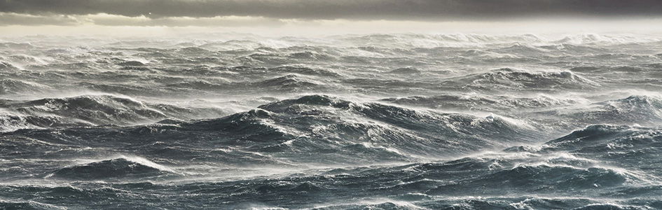
Geologist Dr. Andrew Snelling presents several lines of evidence that both confirm the biblical account of the global Flood and cannot be explained by evolutionary models. From deep sea fossils high atop the Himalayas to the movement of the continents during the Flood, the big picture comes into sharp focus when you look through the lens of the Bible!
Have you ever been “tongue-tied” when asked to provide geologic evidence that the Genesis Flood really did occur, just as the Bible describes? What follows is an overview of six geologic evidences for the Genesis Flood. Together, they will provide you with “ammunition” and a teaching tool for you and others.
Why is it that many people, including many Christians, can’t see the geologic evidence for the Genesis Flood? It is usually because they have bought into the evolutionary idea that “the present is the key to the past.” They are convinced that, because today’s geological processes are so slow, the earth’s rock layers took millions of years to form.
However, if the Genesis Flood really occurred, what evidence would we look
for? We read in Genesis 7 and 8 that “the fountains of the great deep
” were
broken up and poured out water from inside the earth for 150 days (5 months).
Plus, it rained torrentially and globally for 40 days and nights. (“The floodgates
[or windows] of heaven were opened.
”) No wonder all the high hills and the mountains
were covered, meaning the earth was covered by a global ocean. (“. . . the world
that then was, being overflowed with water, perished
” 2 Peter 3:6; KJV.) All
air-breathing life on the land was swept away and perished.
Wouldn’t we expect to find billions of dead plants and animals buried and fossilized in sand, mud, and lime that were deposited rapidly by water in rock layers all over the earth? Of course! That’s exactly what we find. Indeed, based on the biblical description of the Flood, there are six main geologic evidences that testify to its historicity.1
Evidence #1: Fossils of Sea Creatures High Above Sea Level
On every continent we find fossils of sea creatures in rock layers that today are high above sea level. For example, most of the rock layers in the walls of the Grand Canyon contain marine fossils. This includes the Kaibab Limestone at the top of the strata sequence and exposed at the rim of the canyon, which today is 7,000–8,000 feet above sea level.2 This limestone was therefore deposited beneath lime sediment-charged ocean waters, which swept over northern Arizona (and beyond). Other rock layers of the Grand Canyon also contain large numbers of marine fossils. The best example is the Redwall Limestone, which commonly contains fossil brachiopods (a type of clam), corals, bryozoans (lace corals), crinoids (sea-lilies), bivalves (other types of clams), gastropods (marine snails), trilobites, cephalopods, and even fish teeth.3 These marine fossils are found haphazardly preserved in this limestone bed. The crinoids, for example, are found with their columnals (disks), which in life are stacked on top of one another to make up their “stems,” totally separated from one another in what can best be described as a “hash.” Thus, these marine creatures were catastrophically destroyed and buried by the deposition of this lime sediment layer.
All geologists agree that these marine fossils must have been buried in these limestone beds when the latter were deposited by ocean waters.
Fossil ammonites (coiled marine gastropods) are also found in limestone beds high in the Himalayas, reaching up to 30,000 feet above sea level.4 All geologists agree that these marine fossils must have been buried in these limestone beds when the latter were deposited by ocean waters. So how did these marine limestone beds get to be high up in the Himalayas?
There is only one possible explanation—the ocean waters at some time in the past flooded over the continents. Could the continents have then sunk below today’s sea level, so that the ocean waters flooded over them? No! Because the continents are made up of rocks that are less dense (lighter) than both the ocean floor rocks and the mantle rocks beneath the continents. The continents, in fact, have an automatic tendency to rise, and thus “float” on the mantle rocks beneath, well above the level of the ocean floor rocks.5 This is why the continents today have such high elevations compared to the deep ocean floor, and why the ocean basins can accommodate so much water. Rather, the sea level had to rise, so that the ocean waters then flooded up onto, and over, the continents. What would have caused that to happen? There had to be, in fact, two mechanisms to cause this.
First, if the volume of water in the ocean was increased, then sea level would rise. In Genesis 7:11 we read that at the initiation of the Flood all the fountains of the great deep were broken up. In other words, the earth’s crust was cleaved open all around the globe and water burst forth from inside the earth. We then read in Genesis 7:24–8:2 that these fountains were open for 150 days. No wonder the ocean waters flooded up onto and over the continents.
Second, if the ocean floor itself rose, it would then have effectively “pushed” up the sea level. The catastrophic breakup of the earth’s crust, referred to in Genesis 7:11, would not only have released huge volumes of water from inside the earth, but much molten rock.6 The ocean floors would have been effectively replaced by hot lavas. Being less dense than the original ocean floors, these hot lavas would have had an expanded thickness, so the new ocean floors would have effectively risen, raising the sea level by up to more than 3,500 feet. When the ocean floors cooled and sank, the sea level would have fallen and the waters would have drained off the continents into new, deeper ocean basins.
Evidence #2: Rapid Burial of Plants and Animals
Countless billions of plant and animal fossils are found in extensive “graveyards” where they had to be buried rapidly on a massive scale. Often the fine details of the creatures are exquisitely preserved.
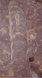
Figure 1. Fossil nautiloids found in the Redwall Limestone were buried rapidly.
For example, billions of straight-shelled, chambered nautiloids (figure 1) are found fossilized with other marine creatures in a 7 feet (2 m) thick layer within the Redwall Limestone of Grand Canyon.7 This fossil graveyard stretches for 180 miles (290 km) across northern Arizona and into southern Nevada, covering an area of at least 10,500 square miles (30,000 km2). These squid-like fossils are all different sizes, from small, young nautiloids to their bigger, older relatives. To form such a vast fossil graveyard required 24 cubic miles (100 km3) of lime sand and silt, flowing in a thick-soup-like slurry at more than 16 feet (5 m) per second (more than 11 miles or 18 km per hour) to catastrophically overwhelm and bury this huge, living population of nautiloids.
Hundreds of thousands of marine creatures were buried with amphibians, spiders, scorpions, millipedes, insects, and reptiles in a fossil graveyard at Montceau-les-Mines, France.8 At Florissant, Colorado, a wide variety of insects, freshwater mollusks, fish, birds, and several hundred plant species (including nuts and blossoms) are buried together.9 Bees and birds have to be buried rapidly in order to be so well preserved.
Alligator, fish (including sunfish, deep sea bass, chubs, pickerel, herring, and gar-pike 3–7 feet [1–2 m] long), birds, turtles, mammals, mollusks, crustaceans, many varieties of insects, and palm leaves (7–9 feet [2–2.5 m] long) were buried together in the vast Green River Formation of Wyoming.10 Notice in these examples how marine and land-dwelling creatures are found buried together. How could this have happened unless the ocean waters rose and swept over the continents in a global, catastrophic Flood? Many trillions of microscopic marine creatures had to have catastrophically buried large ammonites and other marine creatures in the chalk beds of Britain.11 These same beds also stretch right across Europe to the Middle East, as well as into the Midwest of the United States, forming a global-scale fossil graveyard. More than seven trillion tons of vegetation is buried in the world’s coal beds found across every continent, including Antarctica.
Such was the speed at which many creatures were buried and fossilized—under catastrophic flood conditions—that they were exquisitely preserved. There was no destruction of many fish, which were buried so rapidly, virtually alive, that even fine details of fins and eye sockets have been preserved. Many trilobites have been so exquisitely preserved that even the compound lens systems in their eyes are still available for detailed study.
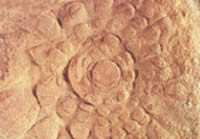
Figure 2. Soft-bodied marine creatures, such as this fossilized jellyfish (Mawsonites spriggi), are finely preserved in a sandstone bed.
Mawsonites spriggi, when discovered, was identified as a fossilized jellyfish (figure 2). It was found in a sandstone bed that covers more than 400 square miles (1,040 km2) of outback South Australia.12 Millions of such soft-bodied marine creatures are exquisitely preserved in this sandstone bed. Consider what happens to soft-bodied creatures like jellyfish when washed up on a beach today. Because they consist only of soft “jelly,” they melt in the sun and are also destroyed by waves crashing onto the beach. Based on this reality, the discoverer of these exquisitely preserved soft-bodied marine creatures concluded that all of them had to be buried in less than a day!
Some sea creatures were buried alive and fossilized so quickly that they were “caught in the act” of eating their last meal, or at the moment of giving birth to a baby! One minute a huge ichthyosaur had just given birth to her baby, then seconds later, without time to escape, mother and baby were buried and “snap frozen” in a catastrophic “avalanche” of lime mud.
These are but a few examples of the many hundreds of fossil graveyards found all over the globe that are now well-documented in the geological literature.13 The countless billions of fossils in these graveyards, in many cases exquisitely preserved, testify to the rapid burial of plants and animals on a global scale in a watery cataclysm and its immediate aftermath.
Evidence #3: Rapidly Deposited Sediment Layers Spread Across Vast Areas
On every continent are found layers of sedimentary rocks over vast areas. Many of these can be traced all the way across continents, and even between continents. Furthermore, geologists find evidence that the sediments were deposited rapidly.
Consider the sedimentary rock layers exposed in the walls of the Grand Canyon. This sequence of layers is not unique to that region of the United States. For more than 50 years geologists have recognized that these strata belong to six megasequences (very thick, distinctive sequences of sedimentary rock layers) that can be traced right across North America.14
The lowest of the Grand Canyon’s sedimentary layers is the Tapeats Sandstone, belonging to the Sauk Megasequence. It and its equivalents cover much of the United States. We can hardly imagine what forces were necessary to deposit such a vast, continent-wide series of deposits. Yet at the base of this sequence are huge boulders and sand beds deposited by storms. Both are evidence that massive forces deposited these layers rapidly and violently right across the entire United States. Slow-and-gradual (present-day uniformitarian) processes cannot account for this evidence, but the Genesis Flood surely can!
The Grand Canyon’s Redwall Limestone belongs to the Kaskaskia Megasequence. The same limestones appear in many places across North America, as far as Tennessee and Pennsylvania. These limestones also appear in the exact same position in the strata sequences, and they have the exact same fossils and other features in them. What is even more remarkable is that the same Carboniferous limestone beds also appear in England, again containing the same fossils and other features.
The Cretaceous chalk beds of southern England are well known because they appear as spectacular white cliffs along the coast. The same chalk beds can be traced westward across England and appear again in Northern Ireland. In the opposite direction, these same chalk beds can be traced across France, the Netherlands, Germany, Poland, southern Scandinavia, and other parts of Europe to Turkey, then to Israel and Egypt in the Middle East, and even as far as Kazakhstan.15
Remarkably, the same chalk beds with the same fossils in them, and with the same distinctive strata above and below them, are also found in the Midwest United States, from Nebraska in the north to Texas in the south, and in the Perth Basin of Western Australia.
Consider another feature—coal beds. In the northern hemisphere, the Upper Carboniferous (Pennsylvanian) coal beds of the eastern and Midwest United States are the same coal beds, with the same plant fossils, in Britain and Europe, stretching halfway around the globe, from Texas to the Donetz Basin north of the Caspian Sea in the former USSR.16 In the southern hemisphere, the same Permian coal beds are found in Australia, Antarctica, India, South Africa, and even South America! These beds share the same kind of plant fossils across the region (but they are different from those in the Pennsylvanian coal beds).
The buff-colored Coconino Sandstone is very distinctive in the walls of the Grand Canyon. It has an average thickness of 315 feet and covers an area of at least 200,000 square miles eastward across adjoining states.17 So the volume of sand in the Coconino Sandstone layer is at least 10,000 cubic miles!
This layer also contains physical features called cross beds. While the overall layer of sandstone is horizontal, these features are clearly visible as sloped beds. These cross beds are remnants of the sand waves produced by the water currents that deposited the sand (like sand dunes, but underwater). So it can be demonstrated that water, flowing at 3–5 miles per hour, deposited the Coconino Sandstone as massive sheets of sand, with sand waves up to 60 feet high.18 At this rate, the whole Coconino Sandstone layer (all 10,000 cubic miles of sand) would have been deposited in just a few days!
Sediment layers that spread across vast continents are evidence that water covered the continents in the past. Even more dramatic are the fossil-bearing sediment layers that were deposited rapidly right across many or most of the continents at the same time. To catastrophically deposit such extensive sediment layers implies global flooding of the continents. And these are only a few examples.19
Evidence #4: Sediment Transported Long Distances
When the Flood waters swept over the continents and rapidly deposited sediment layers across vast areas, these sediments had to have been transported from distant sources. For example, as was mentioned above, the Coconino Sandstone, seen spectacularly in the walls of the Grand Canyon, has an average thickness of 315 feet, covers an area of at least 200,000 square miles, and thus contains at least 10,000 cubic miles of sand.20 Where did this sand come from and how do we know?
The sand grains are pure quartz (a natural glass mineral), which is why the Coconino Sandstone is such a distinctive buff color. Directly underneath it is the strikingly different red-brown Hermit Formation, consisting of siltstone and shale. Sand for the Coconino Sandstone could not have come from the underlying Hermit Formation.
The sloping remnants of sand “waves” in the Coconino Sandstone point to the south, indicating the water that deposited the sand flowed from the north.21 Another clue is that the Coconino Sandstone thins to zero to the north in Utah, but the Hermit Formation spreads further into Utah and beyond. So the Coconino’s pure quartz sand had to come from a source even further north, above the red-brown Hermit.
The Grand Canyon has another layer with sands that must have come from far away—the sandstone beds within the Supai Group strata between the Hermit Formation and the Redwall Limestone. In this case, the sand “wave” remnants point to the southeast, so the sand grains had to be deposited by water flowing from a source in the north and west. However, to the north and west of the Grand Canyon we find only Redwall Limestone underneath the Supai Group, so there is no nearby source of quartz sand for these sandstone beds.22 Thus, an incredibly long distance must be postulated for the source of Supai Group sand grains, probably from a source as far away as northern Utah or even Wyoming.23
Higher in the strata sequence is the Navajo Sandstone of southern Utah, best seen in the spectacular mesas and cliffs in and around Zion National Park. The Navajo Sandstone is well above the Kaibab Limestone, which forms the rim rock of Grand Canyon. Like Grand Canyon sandstone, this sandstone also consists of very pure quartz sand, giving it a distinctive brilliant white color, and it also contains remnants of sand “waves.”
However, we have to look even farther for the original rocks that eroded to form the sand in this sandstone layer. Fortunately, within this sandstone we find grains of the mineral zircon, which is relatively easy to trace to its source because zircon usually contains radioactive uranium. By “dating” these zircon grains, using the uranium-lead (U-Pb) radioactive method, it has been postulated that the sand grains in the Navajo Sandstone came from the Appalachians of Pennsylvania and New York, and from former mountains farther north in Canada. If this is true, the sand grains were transported about 1,250 miles right across North America24 (figure 3).
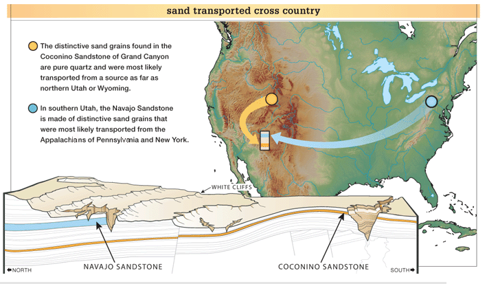
Figure 3: The deposition of these layers defies any uniformitarian explanation.
This “discovery” poses somewhat of a dilemma for conventional uniformitarian (slow-and-gradual) geologists, because no known sediment transport system, even today, is capable of carrying sand right across the entire North American continent during the required millions of years. It must have been water over an area even bigger than the continent. All they can do is postulate that some unknown transcontinental river system must have done the job. But even in their scientific belief system of earth history, it is impossible for such a river to have persisted for millions of years.
Yet the evidence is overwhelming that the water was flowing in one direction. More than half a million measurements have been collected from 15,615 localities recording water current direction indicators throughout the geologic record of North America. Based on these measurements, water moved sediments right across the continent, from the east and northeast to the west and southwest throughout the so-called Paleozoic.25 This pattern continued on up into the Mesozoic, when the Navajo Sandstone was deposited, although some water currents shifted more southward. How could water be flowing right across the North American continent consistently for hundreds of millions of years? Absolutely impossible!
The only logical and viable explanation is the global cataclysmic Genesis Flood. Only the water currents of a global ocean, lasting a few months, could have transported such huge volumes of sediments right across North America to deposit the thick strata sequences which blanket the continent.26
Evidence #5: Rapid or No Erosion Between Strata
If the fossil-bearing layers took hundreds of millions of years to accumulate, then we would expect to find many examples of weathering and erosion after successive layers were deposited. The boundaries between many sedimentary strata should be broken by lots of topographic relief with weathered surfaces. After all, shouldn’t periods of weathering and erosion for millions of years follow each deposition?
Shouldn’t periods of weathering and erosion for millions of years follow each deposition?
On the other hand, in the cataclysmic global Flood most of the fossil-bearing layers would have accumulated in just over one year. Under such catastrophic conditions, even if land surfaces were briefly exposed to erosion, such erosion (called sheet erosion) would have been rapid and widespread, leaving behind flat and smooth surfaces. The erosion would not create the localized topographic relief (hills and valleys) we see forming at today’s snail’s pace. So if the Genesis Flood caused the fossil-bearing geologic record, then we would only expect evidence of rapid or no erosion at the boundaries between sedimentary strata.
At the boundaries between some sedimentary layers we find evidence of only rapid erosion. In most other cases, the boundaries are flat, featureless, and knife-edge, with absolutely no evidence of any erosion, as would be expected during the Genesis Flood.
The Grand Canyon offers numerous examples of strata boundaries that are consistent with deposition during the Genesis Flood.27 However, we will focus here on just four, which are typical of all the others, appearing at the bases of the Tapeats Sandstone, Redwall Limestone, Hermit Formation, and Coconino Sandstone.
The strata below the Tapeats Sandstone has been rapidly eroded and then extensively scraped flat (planed off). We know that this erosion occurred on a large scale because we see its effects from one end of the Grand Canyon to the other. This massive erosion affected many different underlying rock layers—granites and metamorphic rocks—and tilted sedimentary strata.
There are two evidences that this large-scale erosion was also rapid. First, we don’t see any evidence of weathering below the boundary—we don’t see the expected soils.28 Second, we find boulders and features known as “storm beds” in the Tapeats Sandstone above the boundary.29 Storm beds are sheets of sand with unique internal features only produced by storms, such as hurricanes. Boulders and storm beds aren’t deposited slowly.
Below the base of the Redwall Limestone the underlying Muav Limestone has been rapidly eroded in a few localized places to form channels. These channels were later filled with lime sand to form the Temple Butte Limestone. Apart from these rare exceptions, the boundary between the Muav and Redwall Limestones, as well as between the Temple Butte and Redwall Limestones, are flat and featureless, hallmarks of continuous deposition.
Indeed, in some locations the boundary between the Muav and Redwall Limestones is impossible to find because the Muav Limestone continued to be deposited after the Redwall Limestone began.30 These two formations appear to intertongue (thin beds of each formation are interleaved with one another), so the boundary is gradational. This feature presents profound problems for uniformitarian geology. The Muav Limestone was supposedly deposited 500–520 million years ago,31 the Temple Butte Limestone was deposited about 100 million years later (380–400 million years ago),32 and then the Redwall Limestone was deposited several million years later (330–340 million years ago).33 It is much more logical to believe that these limestones were deposited continuously, without any intervening millions of years.
The boundary between the Hermit Formation and the Esplanade Sandstone is often cited as evidence of erosion that occurred over millions of years after sediments had stopped building up.34 However, the evidence indicates that water was still depositing material, even as erosion occurred. In places, the Hermit Formation’s silty shales are intermingled (intertongued) with the Esplanade Sandstone, indicating that a continuous flow of water carried both silty mud and quartz sand into place. Thus, there were no millions of years between these layers.35
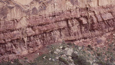
Figure 4. The flat, featureless boundary between these two layers indicates that the top layer (Coconino Sandstone) was laid down right after the bottom layer (Hermit Formation), before any erosion could occur.
Finally, the boundary between the Coconino Sandstone and the Hermit Formation is flat, featureless, and knife-edge from one end of the Grand Canyon to the other (figure 4). There is absolutely no evidence of any erosion on the Hermit Formation before the Coconino Sandstone was deposited. That alone is amazing.
The fossil-bearing portion of the geologic record consists of tens of thousands of feet of sedimentary layers, of which about 4,500 feet are exposed in the walls of the Grand Canyon. If this enormous thickness of sediments were deposited over 500 or more million years, then some boundaries between layers should show evidence of millions of years of slow erosion, just as erosion is occurring on some land surfaces today. On the other hand, if this enormous thickness of sediments were all deposited in just over a year during the global cataclysmic Genesis Flood, then the boundaries between the layers should show evidence of continuous rapid deposition, with only occasional evidence of rapid erosion, or of no erosion at all. And that’s exactly what we find, as illustrated by strata boundaries in the Grand Canyon.
Evidence #6: Many Strata Laid Down in Rapid Succession
The sedimentary units in the Grand Canyon are thought, by uniformitarian geologists, to have been deposited and deformed over the past 500 million years. If it really did take millions of years for these sedimentary sequences to be deposited, then individual sediment layers would not have been deposited rapidly, nor would the sequences have been laid down continuously. In contrast, if the Genesis Flood deposited all these strata in a little more than a year, then the individual layers would have been deposited in rapid succession.
Do we see evidence in the walls of the Grand Canyon that the sedimentary layers were all laid down in quick succession? Yes, absolutely! The entire sequence of sedimentary strata was still soft during subsequent folding and experienced only limited fracturing. These rock layers would have broken and shattered unless all the strata were immediately folded while the sediment was still relatively soft and pliable (figure 5).
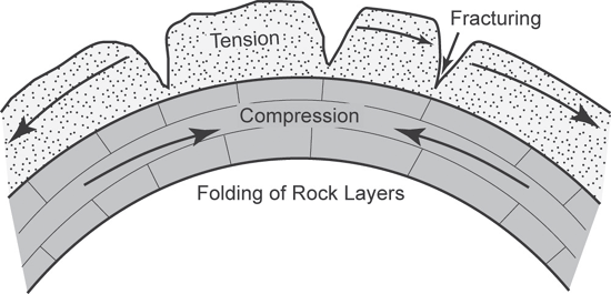
Figure 5. When solid, hard rock is bent (or folded) it invariably fractures and breaks because it is brittle. Rock will bend only if it is still soft and pliable, like modeling clay. If clay is allowed to dry out, it is no longer pliable but hard and brittle, so any attempt to bend it will cause it to break and shatter.
When solid, hard rock is bent (or folded) it invariably fractures and breaks because it is brittle.36 Rock will bend only if it is still soft and pliable—“plastic” like modeling clay or children’s play-dough. If such modeling clay is allowed to dry and/or is baked in an oven, it is no longer pliable but hard and brittle, so any attempt to bend it will cause it to break and shatter.
When sediments are deposited by water in a layer, some water is trapped between the sediment grains. Clay particles may also be among the sediment grains. The pressure of other sediment layers on top of each layer squeezes the particles closer together and forces out much of the water. The internal heat of the earth may also cause additional dehydration of the sediments. Removal of the water dries the sediment layer and converts the chemicals that were in the water and between the clay particles into a natural cement. This cement transforms the originally soft and wet sediment layer into a hard, brittle rock layer.
This process, known technically as diagenesis, can be exceedingly rapid.37 It is known to occur within hours but generally takes days or months, depending on the prevailing conditions. It doesn’t take millions of years, even under today’s slow-and-gradual geologic conditions.
The 4,500-foot sequence of sedimentary layers in the walls of the Grand Canyon stands well above today’s sea level. Earth movements in the past pushed up this sedimentary sequence to form the Kaibab Plateau. However, the eastern portion of the sequence (in the eastern Grand Canyon and Marble Canyon) was not pushed up as much and is about 2,500 feet lower than the height of the Kaibab Plateau. The boundary between the Kaibab Plateau and the less uplifted eastern canyons is marked by a large, step-like fold, producing what is called the East Kaibab Monocline.
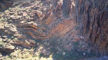
Figure 6. It is possible to see these folded sedimentary layers in several side canyons. All these layers had to be soft and pliable at the same time in order for these layers to be folded without fracturing. Here the folded Tapeats Sandstone can be seen in Carbon Canyon.
It’s possible to see these folded sedimentary layers in several side canyons. For example, the folded Tapeats Sandstone can be seen in Carbon Canyon (figure 6). Notice that these sandstone layers were bent 90° (a right angle), yet the rock was not fractured or broken in the fold axis or hinge line (apex) of the fold. Similarly, the folded Muav and Redwall Limestone layers can be seen along nearby Kwagunt Creek. The folding of these limestones did not cause them to fracture and break either, as would be expected for ancient, brittle rocks. The obvious conclusion is that these sandstone and limestone layers were all folded and bent while the sediments were still soft and pliable, and very soon after they were deposited.
Herein lies an insurmountable dilemma for uniformitarian (long-age) geologists. They maintain that the Tapeats Sandstone and Muav Limestone were deposited 500–520 million years ago;38 the Redwall Limestone, 330–340 million years ago;39 then the Kaibab Limestone at the top of the sequence, supposedly 260 million years ago.40 However, the Tapeats Sandstone was supposedly deposited some 440 million years before the Kaibab Plateau was uplifted, which caused the folding (supposedly only about 60 million years ago).41 How could the Tapeats Sandstone and Muav Limestone still be soft and pliable, as though they had just been deposited, and not subjected yet to diagenesis, without fracturing and shattering when they were folded 440 million years after their deposition?
The conventional explanation is that under the pressure and heat of burial, the hardened sandstone and limestone layers were bent so slowly they behaved as though they were plastic and thus did not break.42 However, pressure and heat would have caused detectable changes in the minerals of these rocks, telltale signs of metamorphism.43 But such metamorphic minerals or re-crystallization due to such plastic behavior44 is not observed in these rocks. The sandstone and limestone in the folds are identical to sedimentary layers elsewhere.
The only logical conclusion is that the 440-million year delay between deposition and folding never happened! Instead, the Tapeats-Kaibab strata sequence was laid down in rapid succession early during the year of the Genesis Flood, followed by uplift of the Kaibab Plateau within the last months of the Flood. This alone explains the folding of the whole strata sequence without appreciable fracturing.
Conclusion
In this chapter we have documented that, when we accept God’s eyewitness account of the Flood in Genesis 7–8 as an actual event in earth history, then we find that the geologic evidence is absolutely in harmony with the Word of God. As the ocean waters flooded over the continents, they must have buried plants and animals in rapid succession. These rapidly deposited sediment layers were spread across vast areas, preserving fossils of sea creatures in layers that are high above the current (receded) sea level. The sand and other sediments in these layers were transported long distances from their original sources. We know that many of these sedimentary strata were laid down in rapid succession because we don’t find evidence of slow erosion between the strata.
Jesus Christ our Creator (John 1:1–3; Colossians 1:16–17), who is the Truth and would never tell us a lie, said that during the “days of Noah” (Matthew 24:37; Luke 17:26–27) “Noah entered the ark” and “the Flood came and took them all away” (Matthew 24:38–39). He spoke of these events as real, literal history, describing a global Flood that destroyed all land life not on the ark. Therefore, we must believe what He told us, rather than believe the ideas of fallible scientists who weren’t there to see what happened in the earth’s past. Thus, we shouldn’t be surprised when the geologic evidence in God’s world (rightly understood by asking the right questions) agrees exactly with God’s Word, affirmed by Jesus Christ.
The New Answers Book 3

Do you have answers to the big questions about the Christian faith, evolution, creation, and the biblical worldview?
Read Online Buy BookFootnotes
- I want to acknowledge that these geologic evidences have also been elaborated on by my colleague Dr. Steve Austin at the Institute for Creation Research, in his book Grand Canyon: Monument to Catastrophe (Santee, CA: Institute for Creation Research, 1994), p. 51–52.
- R.L. Hopkins and K.L. Thompson, “Kaibab Formation,” in S.S. Beus and M. Morales, eds., Grand Canyon Geology, 2nd edition (New York, NY: Oxford University Press, 2003), p. 196–211.
- S.S. Beus, “Redwall Limestone and Surprise Canyon Formation,” in S.S. Beus and M. Morales, eds., Grand Canyon Geology, 2nd edition (New York, NY: Oxford University Press, New York, 2003), p. 115–135.
- J.P. Davidson, W.E. Reed, and P.M. Davis, “The Rise and Fall of Mountain Ranges,” in Exploring Earth: An Introduction to Physical Geology (Upper Saddle River, NJ: Prentice Hall, 1997), p. 242–247.
- J.P. Davidson, W.E. Reed, and P.M. Davis, “Isostasy,” in Exploring Earth: An Introduction to Physical Geology (Upper Saddle River, NJ: Prentice Hall, 1997), p. 124–129.
- A.A. Snelling,
“A Catastrophic Breakup: A Scientific Look at Catastrophic Plate Tectonics,”
Answers April–June 2007, p. 44–48; A.A. Snelling, “
Can Catastrophic Plate Tectonics Explain Flood Geology?” in Ken Ham, ed., The New Answers Book 1 (Green Forest, AR: Master Books, 2006), p. 186–197. - S.A. Austin, “Nautiloid Mass Kill and Burial Event, Redwall Limestone (Lower Mississippian), Grand Canyon Region, Arizona and Nevada,” in Proceedings of the Fifth International Conference on Creationism, R.L. Ivey, ed., (Pittsburgh, PA: Creation Science Fellowship, 2003), p. 55–99.
- B. Heyler and C.M. Poplin, “The Fossils of Montceau-les-Mines,” Scientific American, September 1988, p. 70–76.
- T.D.A. Cockerell, “The Fossil Flora and Fauna of the Florissant Shales,” University of Colorado Studies 3 (1906): 157–176.
- L. Grande, “Paleontology of the Green River Formation with a Review of the Fish Fauna,” The Geological Survey of Wyoming Bulletin 63 (1984).
- J.M. Hancock, “The Petrology of the Chalk,” Proceedings of the Geologists’ Association 86 (1975): 499–536; B. Smith and D.J. Batten, “Fossils of the Chalk,” Field Guides to Fossils, no. 2, 2nd edition (London: The Palaeontological Association, 2002).
- R.C. Sprigg, “Early Cambrian (?) Jellyfishes from the Flinders Ranges, South Australia,” Transactions of the Royal Society of South Australia 71 no. 2 (1947): 212–224; M.F. Glaessner and M. Wade, “The Late Precambrian Fossils from Ediacara, South Australia,” Palaeontology 9 (1966): 599–628.
- For example: D.J. Bottjer et al., eds., Exceptional Fossil Preservation: A Unique View on the Evolution of Marine Life (New York, NY: Columbia University Press, 2002).
- L.L. Sloss, “Sequences in the Cratonic Interior of North America,” Geological Society of America Bulletin 74 (1963): 93–114.
- D.V. Ager, The Nature of the Stratigraphical Record (London: Macmillan, 1973), p. 1–2.
- Ibid., p. 6–7.
- D.L. Baars, “Permian System of Colorado Plateau,” American Association of Petroleum Geologists Bulletin 46 (1962): 200–201; J.M. Hills and F.E. Kottlowski, Correlation of Stratigraphic Units of North America-Southwest/Southwest Mid-Continent Region (Tulsa, OK: American Association of Petroleum Geologists, 1983); R.C. Blakey and R. Knepp, “Pennsylvanian and Permian Geology of Arizona,” in J.P. Jenney and S.J. Reynolds, eds., “Geologic Evolution of Arizona,” Arizona Geological Society Digest 17 (1989): 313–347.
- A.A. Snelling and S.A. Austin, “Startling Evidence of Noah’s Flood,” Creation Ex Nihilo 15 no. 1 (1992): 46–50; S.A. Austin, ed., Grand Canyon: Monument to Catastrophe (Santee, CA: Institute for Creation Research, 1994), p. 28–36.
- Ager, The Nature of the Stratigraphical Record, p. 1–13.
- D.L. Baars, “Permian System of Colorado Plateau,” American Association of Petroleum Geologists Bulletin 46 (1962): 200–201; J.M. Hills and F.E. Kottlowski, Correlation of Stratigraphic Units of North America-Southwest/Southwest Mid-Continent Region (Tulsa, OK: American Association of Petroleum Geologists, 1983); R.C. Blakey and R. Knepp, “Pennsylvanian and Permian Geology of Arizona,” in J.P. Jenney and S.J. Reynolds, eds., “Geologic Evolution of Arizona,” Arizona Geological Society Digest 17 (1989): 313–347.
- Austin, Grand Canyon: Monument to Catastrophe, p. 36.
- J.S. Shelton, Geology Illustrated (San Francisco, CA: WH Freeman, 1966), p. 280.
- R.C. Blakey, “Stratigraphy of the Supai Group (Pennsylvanian-Permian), Mogollon Rim, Arizona,” in S.S. Beus and R.R. Rawson, eds., Carboniferous Stratigraphy in the Grand Canyon Country, Northern Arizona and Southern Nevada (Falls Church, VA: American Geological Institute, 1979), p. 102.
- J.M. Rahl et al., “Combined Single-grain (U-Th)/He and U/Pb Dating of Detrital Zircons from the Navajo Sandstone, Utah,” Geology 31 no. 9 (2003): 761–764.
- S.R. Dickinson and G.E. Gehrels, “U-Pb Ages of Detrital Zircons from Permian and Jurassic Eolian Sandstones of the Colorado Plateau, USA: Paleogeographic Implications,” Sedimentary Geology 163 (2003): 29–66.
- A.V. Chadwick, “Megatrends in North American Paleocurrents,” www.origins.swau.edu/ papers/global/paleocurrents/default.html.
- Austin, Grand Canyon: Monument to Catastrophe, p. 42–52.
- N.E.A. Hinds, “Ep-Archean and Ep-Algonkian Intervals in Western North America,” Carnegie Institution of Washington Publication 463, vol. 1, 1935.
- A.V. Chadwick, “Megabreccias: Evidence for catastrophism,” Origins 5 (1978): 39–46.
- A.A. Snelling, “The Case of the ‘Missing’ Geologic Time,” Creation Ex Nihilo 14, no. 3 (1992): 30–35.
- L.T. Middleton and D.K. Elliott, “Tonto Group,” in S.S. Beus and M. Morales, eds., Grand Canyon Geology, 2nd edition (New York, NY: Oxford University Press, 2003), p. 90–106.
- S.S. Beus, “Temple Butte Formation,” in S.S. Beus and M. Morales, eds., Grand Canyon Geology, 2nd edition (New York, NY: Oxford University Press, 2003), p. 107–114.
- S.S. Beus, “Redwall Limestone and Surprise Canyon Formation,” in S.S. Beus and M. Morales, eds., Grand Canyon Geology, 2nd edition (New York, NY: Oxford University Press, 2003), p. 115–135.
- L.F. Noble, “A Section of Paleozoic Formations of the Grand Canyon at the Bass Trail,” U.S. Geological Survey Professional Paper 131-B, 1923, p. 63–64.
- E.D. McKee, “The Supai Group of Grand Canyon,” U.S. Geological Survey Professional Paper 1173, 1982, p. 169–202; R.C. Blakey, “Stratigraphy and Geologic History of Pennsylvanian and Permian rocks, Mogollon Rim Region, Central Arizona and Vicinity,” Geological Society of America Bulletin 102 (1990): 1189–1217; R.C. Blakey, “Supai Group and Hermit Formation,” in S.S. Beus and M. Morales, eds., Grand Canyon Geology, 2nd edition (New York, NY: Oxford University Press, 2003), p. 136–162.
- E.S. Hills, “Physics of Deformation,” Elements of Structural Geology (London: Methuen & Co., 1970), p. 77–103; G.H. Davis and S.J. Reynolds, “Kinematic Analysis,” Structural Geology of Rocks and Regions, 2nd edition (New York, NY: John Wiley & Sons, 1996), p. 38–97.
- Z.L. Sujkowski, “Diagenesis,” Bulletin of the American Association of Petroleum Geologists 42 (1958): 2694–2697; H. Blatt, Sedimentary Petrology, 2nd edition (New York, NY: W.H. Freeman and Company, 1992).
- L.T. Middleton and D.K. Elliott, “Tonto Group,” in S.S. Beus and M. Morales, eds., Grand Canyon Geology, 2nd edition (New York, NY: Oxford University Press, 2003), p. 90–106.
- S.S. Beus, “Redwall Limestone and Surprise Canyon Formation,” in S.S. Beus and M. Morales, eds., Grand Canyon Geology, 2nd edition (New York, NY: Oxford University Press, 2003), p. 115–135.
- R.L. Hopkins and K.L. Thompson, “Kaibab Formation,” in S.S. Beus and M. Morales, eds., Grand Canyon Geology, 2nd edition (New York, NY: Oxford University Press, 2003), p. 196–211.
- P.W. Huntoon, “Post-Precambrian Tectonism in the Grand Canyon Region,” in S.S. Beus and M. Morales, eds., Grand Canyon Geology, 2nd edition (New York, NY: Oxford University Press, 2003), p. 222–259.
- E.S. Hills, “Environment, Time and Material,” Elements of Structural Geology (London: Methuen & Co., 1970), p. 104–139; G.H. Davis and S.J. Reynolds, “Dynamic Analysis,” Structural Geology of Rocks and Regions, 2nd edition (New York, NY: John Wiley & Sons, 1996), p. 98–149.
- R.H. Vernon, Metamorphic Processes: Reactions and Microstructure Development (London: George Allen and Unwin, 1976); K. Bucher and M. Frey, Petrogenesis of Metamorphic Rocks, 7th edition (Berlin: Springer-Verlag, 2002).
- Vernon, Metamorphic Processes: Reactions and Microstructure Development; G.H. Davis and S.J. Reynolds, “Deformation Mechanisms and Microstructures,” Structural Geology of Rocks and Regions, 2nd edition (New York, NY: John Wiley & Sons, 1996), p. 150–202.
Support the creation/gospel message by donating or getting involved!

Answers in Genesis is an apologetics ministry, dedicated to helping Christians defend their faith and proclaim the good news of Jesus Christ.
- Customer Service 800.778.3390
- Available Monday–Friday | 9 AM–5 PM ET
- © 2026 Answers in Genesis